Dave’s 2025 Weather Wall Calendar packs a lot of goodies into one piece:
~ Colorful Local Photos & Educational Content
~ WMass Community-Oriented & Contemplative
~ Affordable, Useful, & Practical
~ Great for holiday gifts (order info below)
2025 DHTWN Weather Wall Calendar
(Securely Order via Cards, Venmo, PayPal, or Check)
~~~~~~~~~~~~~~~~~~~~~~
TABLE OF CONTENTS
* Daily Celestials (Sun/Moon Data)
* Sponsor Note
* DHTWN Announcements
* Morning Discussion
* TIP: Scroll below for sections, or read all
~~~~~~~~~~~~~~~~~~~~~~
YOUR DAILY CELESTIALS
~~~~~~~~~~~~~~~~~~~~~~
STAR:
–OUR STAR ROSE AT: 6:54am this morning
–OUR STAR WILL SET AT: 6:20pm this evening
–TOTAL DAYLIGHT TIME: 11 hours and 26 minutes
MOON:
–OUR MOON WILL RISE AT: 11:52am this morning
–MOON RISE DIRECTION: Southeast
–OUR MOON WILL SET AT: 8:33pm this evening
–MOON SET DIRECTION: Southwest
–MOON PHASE: Waxing Crescent (18.7%)
~~~~~~~~~~~~~~~~~~~~~~
A NOTE FROM OUR SPONSOR
~~~~~~~~~~~~~~~~~~~~~~
Dave Hayes The Weather Nut is Sponsored by Individual Community Members, Patrons, and Tandem Bagel Company… No matter the weather, Tandem Bagel is always there for you at several valley locations to make your mornings brighter! With *New Pizza Bagels(!)*, along with bagels baked fresh daily (including Gluten-Free options), house-whipped cream cheese, coffee, and tons of lunch options, Tandem is the perfect quick stop for lunch, breakfast, or a coffee and bagel to go.
You can either 1) visit them in Easthampton, Northampton, Hadley, Florence, and/or West Springfield, 2) hire them to cater your next event, or 3) use their super-streamlined online ordering tool by visiting their website and clicking the “Catering” or “Order Online” links.
~~~~~~~~~~~~~~~~~~~~~~
DHTWN ANNOUNCEMENTS
~~~~~~~~~~~~~~~~~~~~~~
~ 2025 DHTWN Weather Wall Calendar
(Securely Order via Cards, Venmo, PayPal, or Check)
~ News on Dave’s Upcoming Mobile Weather App
(Late 2024 Release)
~ Subscribe to Dave’s Weekly Newsletter
(Get the free 70-page ebook: Top 15 WMass Storms!)
~~~~~~~~~~~~~~~~~~~~~~
YOUR MORNING DISCUSSION
~~~~~~~~~~~~~~~~~~~~~~
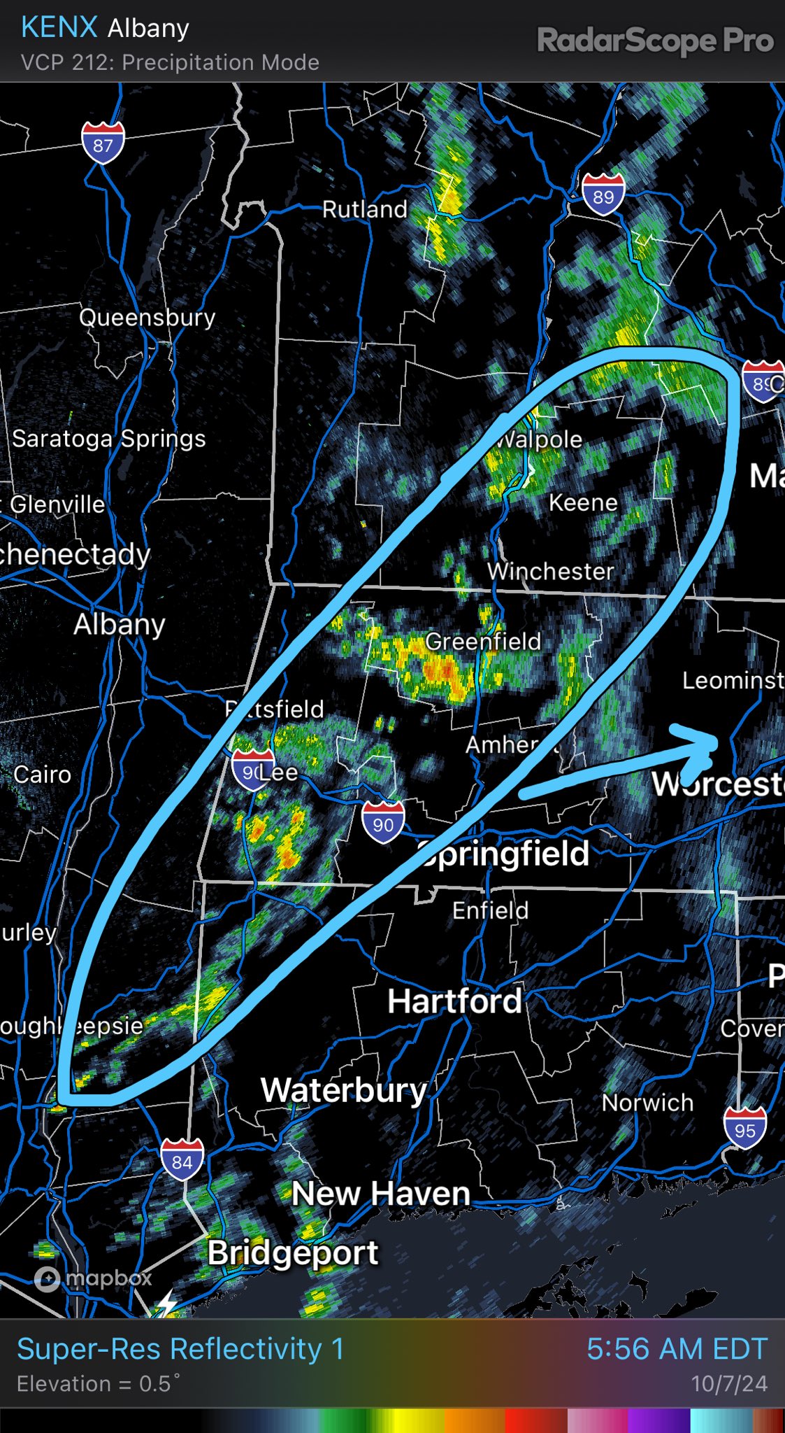
Good morning folks, we’ve got scattered showers moving through the region and some are on the heavier side.
I haven’t seen any lightning strikes yet, but doesn’t mean we can’t get some thunder going, as our mid-level lapse rates (i.e. the temperature gradient from the lower mid-levels to the higher mid-levels of the atmosphere) are quite steep this morning!
This steepness of gradient allows for air to be more buoyant, producing convection, and the potential for taller cells to turn into thunderstorms, and this cold frontal line has that history in its meteorological DNA.
Having said all of that, showers will continue this morning, but keep tracking east at a good clip and be out of here by late morning to early afternoon from west to east (Berkshires to Wistah).
Highs today will climb into the mid to upper 60s for many, but may hang in the low 60s in far northwest MA up into parts of SVT.
We’ll clear out behind the front tonight and with a light northwest wind, lows will come down into the upper 30s to mid 40s so a bunch of chilly mornings are on the way this week.
Overall, the Tuesday through Sunday period looks to feature mostly sunny skies, though there will probably be some exceptions to that rule.
For Tuesday, upper ridging works into the region with drier air, with cooler highs in the upper 50s to mid 60s under mostly sunny skies, with lows either side of 40º.
For mid to late week we’ll see an upper trough north of us that tries to swing some isolated lake effect rain showers and some afternoon mostly fair-weather cloudiness at times through the region on northwest flow.
Gustier winds up to 15-30mph at times should produce a touch of chill given that high temps during this period will generally range in the mid 50s to low 60s, so it’ll feel like Fall during this period for sure.
Lows will generally drop into the mid 30s to low 40s, with the coldest morning falling either Thursday or Friday morning, so some patchy frost is expected.
Friday may warm up into the low to mid 60s, and Saturday looks to become even milder with highs in the 65-70º range, with lows in the 40s Friday and Saturday night.
Sunday looks at least partly sunny thanks to this upper ridging and high pressure to our west, but there are signals that continue to grow that an upper trough will swing down into Quebec and try to capture a disturbance that may generate a coastal storm by Monday.
This could produce the first real rainfall we’ve seen in a while, and I can’t even rule out a few snowflakes up in the southern VT high peaks.
I will keep you updated as we go this week.
Have a great day, and remember that I want my 2025 Weather Calendar to contribute to your life a sense of connection to place, to community, and to provide a zone of daily refuge. Plus, it can serve as a fun holiday gift for others.
2025 DHTWN Weather Wall Calendar
(Securely Order via Cards, Venmo, PayPal, or Check)
“Follow your bliss and the universe will open doors for you where there were only walls.”
― Joseph Campbell
