[8:42AM SAT: 10/5/24] AURORA WATCH TONIGHT! A LOVELY WEEKEND LIES AHEAD WITH WARMER TEMPS TODAY AS CLOUDS CLEAR FOLLOWED BY A CHILLY NIGHT TONIGHT… CLOUDS FILL BACK IN LATE SUNDAY AS A COLD FRONT APPROACHES… A BETTER DRINK OF RAINFALL ARRIVES LATE SUNDAY NIGHT INTO THE FIRST HALF OF MONDAY AVERAGING A HALF TO THREE-QUARTERS OF AN INCH OF PRECIP… WE CLEAR MONDAY, AND THEN THE COOL DOWN COMMENCES FOR TUESDAY THROUGH THE WEEK… PATCHY FROST WILL BE POSSIBLE AS EARLY AS TUESDAY NIGHT… WIND PICKS UP MID TO LATE WEEK WITH REINFORCING COOLER NORTHWEST FLOW… MY 2025 WEATHER WALL CALENDAR SALE LAUNCHES TODAY, CLICK BELOW FOR MORE…
Click to view Photos, Get Info, or Securely Order Today.

TABLE OF CONTENTS
* Daily Celestials (Sun/Moon Data)
* Sponsor Section
* Morning Discussion
* TIP: Scroll to your section, or read all
~~~~~~~~~~~~~~~~~~~~~~
YOUR DAILY CELESTIALS
~~~~~~~~~~~~~~~~~~~~~~
STAR:
–OUR STAR ROSE AT: 6:52am this morning
–OUR STAR WILL SET AT: 6:24pm this evening
–TOTAL DAYLIGHT TIME: 11 hours and 32 minutes
MOON:
–OUR MOON WILL RISE AT: 9:41am this morning
–MOON RISE DIRECTION: East-Southeast
–OUR MOON WILL SET AT: 7:27pm this evening
–MOON SET DIRECTION: West-Southwest
–MOON PHASE: Waxing Crescent (6.6%)
~~~~~~~~~~~~~~~~~~~~~~
>>> A NOTE FROM OUR WEEKEND SPONSOR <<<
Dave Hayes The Weather Nut is Sponsored by Individual Community Members, Patrons, and Gerard, Ghazey & Bates, P.C. GGBPC is a Northampton-based law firm regarded as the voice of pragmatic and well-reasoned estate planning, elder law and tax guidance in Western Massachusetts. The firm specializes in estate planning law, and expertly handles other matters such as Elder Law, Tax Law, as well as Real Estate purchase, sales, and refinance transactions. Contact GGBPC today to see how they can help!
~~~~~~~~~~~~~~~~~~~~~~
YOUR MORNING DISCUSSION
~~~~~~~~~~~~~~~~~~~~~~
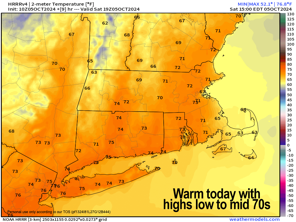
Good morning everybody, we had a few showers pass through this morning, but the last ones over CMass are going to continue to ship east and out to sea, which will allow us to clear out and warm up with highs rising into the low to mid 70s.
Get outside and enjoy it!
With calm wind, clearing skies, and dry air we will observe radiational cooling tonight, and lows should crash into the upper 30s to low 40s for a very chilly night ahead.
This will coincide with a Strong Geomagnetic Storm Watch for a G3 level event, which may push into G4 territory, which means the Aurora may be visible in the western MA region!
For tomorrow, another lovely day arrives with mostly sunny skies, light winds, and highs in the 65-70º range.
Clouds will thicken late in the day and evening as a stronger cold front attached to a storm to our north will sweep into the greater WMass region through Monday mid-day.
Lows Sunday night will sit down to either side of 50º with showers moving into the region.
Showers and possibly even a brief thunderstorm will sweep through Monday morning, which looks like a wet commute at the moment.
Rain should be winding down by mid-day, and we look to end up with about half to three-quarters of an inch of rain, with some folks more towards a quarter inch, and other a bit more.
Highs Monday will rise into the 60s, and then northwest flow will commence at night as we drop our lows to near 40º as skies clear.
Thereafter, we will enter a more sunny, autumnal pattern with northwest flow, and highs in the 50s in the Berkshires and western hilltowns up into SVT and SWNH, with more like upper 50s to mid 60s in the valley points south and east in the rest of WMass, CMass and northern CT. Lows will be more firmly in the 30s as we cool down.
In addition, northwest winds should pick up and gust 15-30mph Wednesday through Friday.
REGARDING FROST POTENTIAL
It is the mid to late week timeframe when we could see low temps well down into the 30s that could produce areas of frost in our region.
Please Note: The NWS will not be issuing Frost Advisories or Freeze Warnings for SVT, SWNH, WMass or CMass as we are past October 1st, which is when their alert program ends for these types of events.
However, northern CT ends on 10/11, so Frost Advisories may come up by end of the week, but I will keep you updated.
Have a great day!
2025 WEATHER WALL CALENDAR AVAILABLE NOW
Click to view Photos, Get Info, or Securely Order Today.
HAIKU OF THE DAY:
Autumnal whispers
Messages from the northwest
They stream toward us
“Follow your bliss and the universe will open doors for you where there were only walls.”
― Joseph Campbell
