
TABLE OF CONTENTS
* Daily Celestials (Sun/Moon Data)
* Sponsor Note
* DHTWN Announcements
* Morning Discussion
* TIP: Scroll below for sections, or read all
~~~~~~~~~~~~~~~~~~~~~~
YOUR DAILY CELESTIALS
~~~~~~~~~~~~~~~~~~~~~~
STAR:
–OUR STAR ROSE AT: 6:36am this morning
–OUR STAR WILL SET AT: 6:50pm this evening
–TOTAL DAYLIGHT TIME: 12 hours and 14 minutes
MOON:
–OUR MOON WILL RISE AT: 8:08pm this evening
–MOON RISE DIRECTION: East-Northeast
–OUR MOON WILL SET AT: 11:05am tomorrow morning
–MOON SET DIRECTION: West-Northwest
–MOON PHASE: Waning Gibbous (91.9%)
~~~~~~~~~~~~~~~~~~~~~~
A NOTE FROM OUR SPONSOR
~~~~~~~~~~~~~~~~~~~~~~
Dave Hayes The Weather Nut is Sponsored by Individual Community Members, Patrons, and Tandem Bagel Company… No matter the weather, Tandem Bagel is always there for you at several valley locations to make your mornings brighter! With *New Pizza Bagels(!)*, along with bagels baked fresh daily (including Gluten-Free options), house-whipped cream cheese, coffee, and tons of lunch options, Tandem is the perfect quick stop for lunch, breakfast, or a coffee and bagel to go.
You can either 1) visit them in Easthampton, Northampton, Hadley, Florence, and/or West Springfield, 2) hire them to cater your next event, or 3) use their super-streamlined online ordering tool by visiting their website and clicking the “Catering” or “Order Online” links.
~~~~~~~~~~~~~~~~~~~~~~
DHTWN ANNOUNCEMENTS
~~~~~~~~~~~~~~~~~~~~~~
~ Subscribe to Dave’s Weekly Newsletter
(Get the free 70-page ebook: Top 15 WMass Storms!)
~ Look for Dave’s New Mobile Weather App
(Late 2024 Release)
~ DHTWN’S Final 10th Anniversary
Weather Wall Calendar
(Sale launches toward October 1)
~~~~~~~~~~~~~~~~~~~~~~
YOUR MORNING DISCUSSION
~~~~~~~~~~~~~~~~~~~~~~
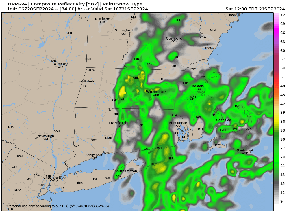
Good morning everybody, we’ve got a few showers moving through the region this morning, but are generally light.
The valley floor sort of represents the western fringe of our ocean storm that has been lashing Cape Cod (especially the outer Cape), and from here east through CMass and EMass we can expect elevated humidity with dewpoints in the low 60s.
We’ll also see some scattered showers at times today, with more of a partly to mostly sunny day expected west of the CT River Valley as the storm’s cloud shield only makes it so far west into New England. Highs will reach the low to mid 70s west, and only in the 60s to maybe 70º east.
Easterly wind gusts will also pick up, about 15-30mph at times, highest to the east.
For tonight, a few showers are possible in CMass and northeast CT with lows in the 50s and continued breezy conditions well east of the valley and lighter north to northeast wind in the WMass region.
For Saturday, the storm looks to bob west and make its closest swipe into New England before high pressure to the north pushes it south and then southeast and away by later Saturday night into early Sunday.
Therefore, Saturday morning I expect showers that may push west past the valley and into the western hilltowns for a time, but these sharp cutoffs with ocean storms are notoriously hard to pinpoint.
Highs Saturday will generally be in the upper 60s, and we should see drying from any showers that DO make it into WMass afternoon, as the recede back into northeast CT and CMass/EMass.
Mostly cloudy skies should persist Saturday night, with clearing from west to east Sunday, with sunshine developing and highs reaching the 65-70º range, followed by chilly lows in the mid to upper 40s under partly cloudy skies.
We should remain dry towards the middle of next week with highs only in the 65-70º range, and lows generally in the mid 40s to low 50s, but clouds will be on the increase as a system moves slowly east from the Great Lakes, potentially bringing needed rain here by Wednesday or Thursday.
This system may help open up the door for a tropical system to feed rainfall into our region by the weekend after this one, or early the following week, so I will keep you updated.
Have a great day!
“Follow your bliss and the universe will open doors for you where there were only walls.”
― Joseph Campbell