
TABLE OF CONTENTS
* Daily Celestials (Sun/Moon Data)
* Sponsor Section
* Morning Discussion
* TIP: Scroll to your section, or read all
~~~~~~~~~~~~~~~~~~~~~~
YOUR DAILY CELESTIALS
~~~~~~~~~~~~~~~~~~~~~~
STAR:
–OUR STAR ROSE AT: 6:29am this morning
–OUR STAR WILL SET AT: 7:00pm this evening
–TOTAL DAYLIGHT TIME: 12 hours and 31 minutes
MOON:
–OUR MOON WILL RISE AT: 5:29pm this afternoon
–MOON RISE DIRECTION: East-Southeast
–OUR MOON WILL SET AT: 3:00am tomorrow morning
–MOON SET DIRECTION: West-Southwest
–MOON PHASE: Waxing Gibbous (82.1%)
~~~~~~~~~~~~~~~~~~~~~~
>>> A NOTE FROM OUR WEEKEND SPONSOR <<<
Dave Hayes The Weather Nut is Sponsored by Individual Community Members, Patrons, and Gerard, Ghazey & Bates, P.C. GGBPC is a Northampton-based law firm regarded as the voice of pragmatic and well-reasoned estate planning, elder law and tax guidance in Western Massachusetts. The firm specializes in estate planning law, and expertly handles other matters such as Elder Law, Tax Law, as well as Real Estate purchase, sales, and refinance transactions. Contact GGBPC today to see how they can help!
~~~~~~~~~~~~~~~~~~~~~~
YOUR MORNING DISCUSSION
~~~~~~~~~~~~~~~~~~~~~~
Good morning everybody, patchy fog with some dense areas in the northern Berkshires, northeast CT and other spots has formed, but will burn off this morning as highs rise into the mid 70s to low 80s. Lows will dip into the mid to upper 50s under partly cloudy skies, with some more patchy fog possible at night.
High pressure dives southeast through Maine this weekend, and as such will continue drying flow into the region, producing another mostly sunny day on Sunday with highs in the mid 70s to low 80s, and lows in the low to mid 50s.
Similar highs are expected Monday and Tuesday with mostly sunny skies and temps either side of 80º as high pressure continues to rule the region.
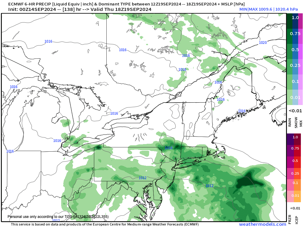
Some clouds start to filter in later Tuesday as a storm takes shape off of the Carolinas.
More likely than not, that storm will develop (see attached graphic), but where will it be directed?
It will depend in part with how high pressure tracks and positions itself by mid-week, as it will either shunt most or all of the storm’s northern periphery to our south, or allow some showers northward toward the latitude of the MassPike in southern MA.
At this point, I still think it’s unlikely see any rainfall, but I will keep you updated.
This mid to late week period should feature highs more into the 70s (a bit cooler), but with milder lows into the low 60s as humidity comes up a bit.
Still, there are no big rain signals until the last week of September.
What we do know is that today is the least 7pm sunset until next Spring, so get outside and enjoy the day, people.
Have a great day!
HAIKU OF THE DAY:
Life is exhausting
We keep swimming anyway
Forward… heads up… go
“Follow your bliss and the universe will open doors for you where there were only walls.”
― Joseph Campbell