
TABLE OF CONTENTS
* Daily Celestials (Sun/Moon Data)
* Sponsor Note
* Join My Newsletter
(& get my Top12WMassStorms ebook!)
* Morning Discussion
* TIP: Scroll below for sections, or read all
~~~~~~~~~~~~~~~~~~~~~~
YOUR DAILY CELESTIALS
~~~~~~~~~~~~~~~~~~~~~~
STAR:
–OUR STAR ROSE AT: 6:14am this morning
–OUR STAR WILL SET AT: 7:26pm this evening
–TOTAL DAYLIGHT TIME: 13 hours and 12 minutes
MOON:
–OUR MOON WILL SET AT: 6:11pm this afternoon
–MOON SET DIRECTION: West-Northwest
–OUR MOON WILL RISE AT: 3:26am tomorrow morning
–MOON RISE DIRECTION: East-Northeast
–MOON PHASE: Waning Crescent (12.3%)
~~~~~~~~~~~~~~~~~~~~~~
A NOTE FROM OUR SPONSOR
~~~~~~~~~~~~~~~~~~~~~~
Dave Hayes The Weather Nut is Sponsored by Individual Community Members, Patrons, and Tandem Bagel Company… No matter the weather, Tandem Bagel is always there for you at several valley locations to make your mornings brighter! With *New Pizza Bagels(!)*, along with bagels baked fresh daily (including Gluten-Free options), house-whipped cream cheese, coffee, and tons of lunch options, Tandem is the perfect quick stop for lunch, breakfast, or a coffee and bagel to go.
You can either 1) visit them in Easthampton, Northampton, Hadley, Florence, and/or West Springfield, 2) hire them to cater your next event, or 3) use their super-streamlined online ordering tool by visiting their website and clicking the “Catering” or “Order Online” links.
~~~~~~~~~~~~~~~~~~~~~~
DAVE’S WEEKLY NEWSLETTER (Top 12 WMass Storms)
DAVE’S MOBILE APP (Late 2024 Release)
~~~~~~~~~~~~~~~~~~~~~~
YOUR MORNING DISCUSSION
~~~~~~~~~~~~~~~~~~~~~~
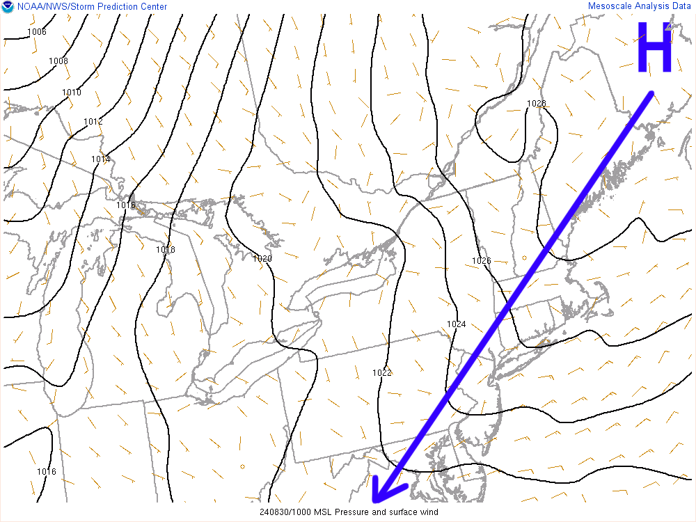
Good morning folks, we’re starting off mostly in the 50s with a couple of light showers in northwest CT but the high pressure cell to our northeast will help dry those up and produce a partly sunny day for us, with the most sun east of the I-91 corridor with highs in the upper 60s to mid 70s and a light southwest wind.
Humidity will start to creep up late tonight along with clouds, as lows dip to the 55-60º range.
Humidity will rise Saturday with highs reaching the low to mid 70s as southwest flow develops ahead of an easterly slow-tracking upper trough, moving out of the Great Lakes and toward northern New England.
Dewpoints will rise into the 60s on Saturday as humidity comes up, and it will be mostly cloudy with a few isolated showers during the day in the warm advection pattern.
The steadier showers and/or isolated thunderstorms should hold off now until later in the evening, and more towards midnight through Sunday morning when the cold front approaches the region. Lows will hang in the 60s overnight.
Sunday morning looks showery at the moment, and it looks quite humid and warm, with dewpoints cresting the 70º mark, and high temps reaching the upper 70s to low 80s.
Showers should abate by early afternoon, and we may get some sunny breaks before the day is out. Lows will drop to the low to mid 50s as drier air starts working back into the region.
By Labor Day, the pick of the long weekend arrives!
It looks to be mostly sunny with highs either side of 70º, light wind, and lows that could really plummet with maximal radiational cooling dropping temps into the upper 30s to mid 40s!
Tuesday through Thursday looks lovely with fair weather and a huge Canadian high pressure system to our west that will slowly be tracking east.
This will help produce sunny skies and highs in the 60s Tuesday, and then the low to mid 70s Wednesday and the mid to upper 70s for Thursday with lows in the 40s Tuesday night, rising into the 50s through mid week.
It will be a gorgeous start to September!
The next chance for a storm is not until next weekend, so for now, enjoy the relatively calm weather.
Have a great day!
“Follow your bliss and the universe will open doors for you where there were only walls.”
― Joseph Campbell