
TABLE OF CONTENTS
* Daily Celestials (Sun/Moon Data)
* Sponsor Note
* Join My Newsletter
(& get my Top12WMassStorms ebook!)
* Morning Discussion
* TIP: Scroll below for sections, or read all
~~~~~~~~~~~~~~~~~~~~~~
YOUR DAILY CELESTIALS
~~~~~~~~~~~~~~~~~~~~~~
STAR:
–OUR STAR ROSE AT: 6:03am this morning
–OUR STAR WILL SET AT: 7:42pm this evening
–TOTAL DAYLIGHT TIME: 13 hours and 39 minutes
MOON:
–OUR MOON WILL RISE AT: 8:29pm this evening
–MOON RISE DIRECTION: East
–OUR MOON WILL SET AT: 8:11am tomorrow morning
–MOON SET DIRECTION: West
–MOON PHASE: Waning Gibbou (99.3%)
~~~~~~~~~~~~~~~~~~~~~~
A NOTE FROM OUR SPONSOR
~~~~~~~~~~~~~~~~~~~~~~
Dave Hayes The Weather Nut is Sponsored by Individual Community Members, Patrons, and Tandem Bagel Company… No matter the weather, Tandem Bagel is always there for you at several valley locations to make your mornings brighter! With *New Pizza Bagels(!)*, along with bagels baked fresh daily (including Gluten-Free options), house-whipped cream cheese, coffee, and tons of lunch options, Tandem is the perfect quick stop for lunch, breakfast, or a coffee and bagel to go.
You can either 1) visit them in Easthampton, Northampton, Hadley, Florence, and/or West Springfield, 2) hire them to cater your next event, or 3) use their super-streamlined online ordering tool by visiting their website and clicking the “Catering” or “Order Online” links.
~~~~~~~~~~~~~~~~~~~~~~
DAVE’S WEEKLY NEWSLETTER (Top 12 WMass Storms)
DAVE’S MOBILE APP (Late 2024 Release)
~~~~~~~~~~~~~~~~~~~~~~
YOUR MORNING DISCUSSION
~~~~~~~~~~~~~~~~~~~~~~
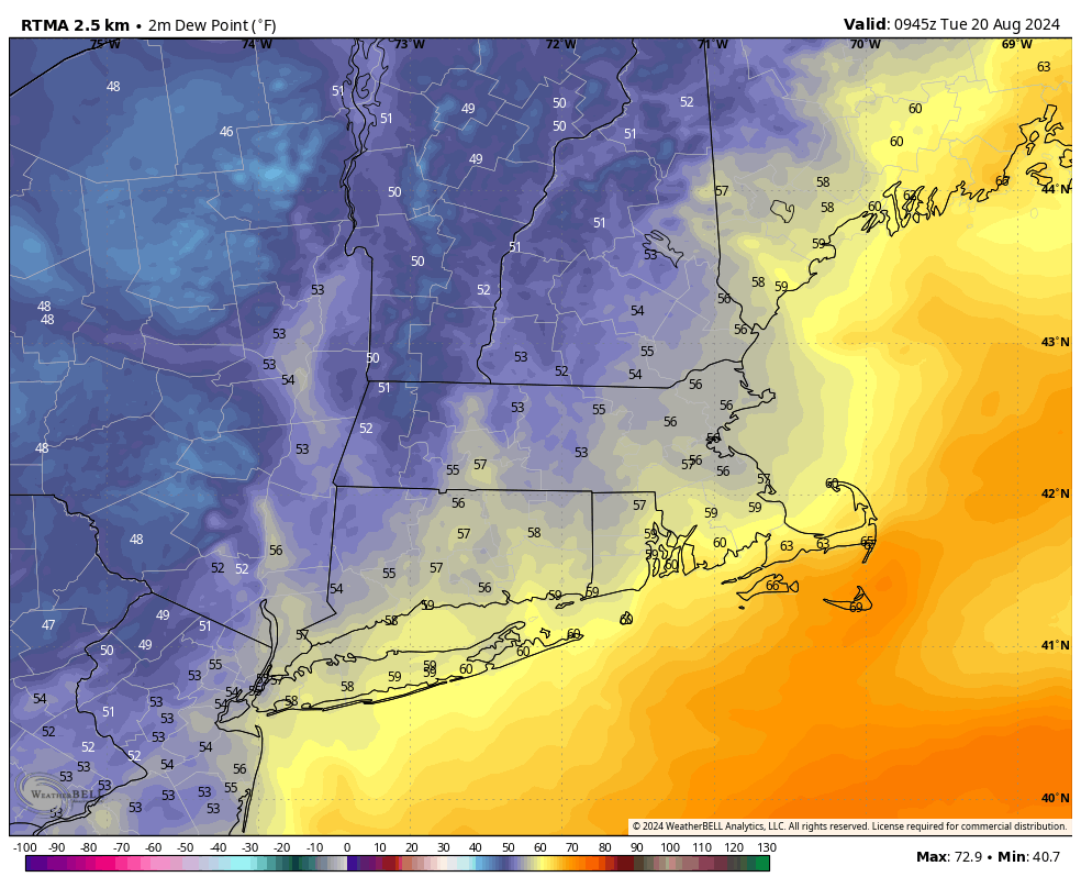
Good morning folks, what a difference 24 hours makes!! Dewpoints pushing 70º yesterday are now into the 50s this morning with gusts either side of 20mph at times out of the northwest.
The Whooshening has arrived!
We still have an upper low to track east through the region over the next couple of days, so we’ll see periods of clouds and sun today and tomorrow, but any morning showers today should evaporate, and we’ll be left with a dry late morning through the rest of the day and night with highs in the mid 60s to low 70s, and dewpoints in the 40s and 50s, woo hoo!
Lows tonight will be a bit mild early, but then drop into the mid 40s to low 50s for a true autumnal feel towards dawn tomorrow morning!
The almost-full moon will be gorgeous to behold tonight, and it will look wonderful at the Pines Theatre at Look Park where you should come out for Performance34, which is the annual local arts fundraiser for Northampton schools – I am performing in 3 out of about 20 bands, and you could not ask for a nicer late-August night at an outdoor show on a lovely lawn!
Ok, enough plugging my music stuff, but for me it truly is the best day of the year! :-)
For tomorrow, a final wave wraps around the upper low still tracking east, and while we will be partly sunny overall, some scattered showers will probably develop north of the Pike in the afternoon and dissipate in the evening.
Highs again will be in the mid 60s to low 70s with lows either side of 50º, and the same goes for Thursday and Thursday night with more sunshine and low humidity.
By Friday, the upper low will be to the east of us, and we will start to warm up and also see high pressure push overhead, which will produce resplendently full sunshine for Friday, through the weekend, and into early next week!
Highs Friday and Saturday will push up into the mid to upper 70s with lows in the 50s, and by Sunday and Monday we’ll bust into the low 80s for highs.
At this point, we may see a brief resurgence of the Bermuda high which would also push higher humidity into our region by early next week, and could really warm us through the 80s by mid-week, possibly pushing 90º by Wednesday or Thursday before a potentially strong mid-latitude cyclone tracks east across southern Canada with a sweeping cold front that may bring severe weather by late next week, and yet another autumnal taste by next weekend.
That’s putting the cart before the horse, but folks, enjoy this new pattern change: after a long 2 months of damp, humid, rainy, thundery, and at times severe weather, we truly deserve a break, and we’ve got it.
Have a great day!
“Follow your bliss and the universe will open doors for you where there were only walls.”
― Joseph Campbell