
[7:12AM MON 8/19/24] POTENTIAL FOR STRONG TO SEVERE THUNDERSTORMS WITH STRONG GUSTY WINDS, SMALL HAIL, AND SOME FLOODING ISSUES, MOSTLY BETWEEN 3-9PM WEST (BERKSHIRES) TO EAST (WISTAH)… ONE MORE SOUPY SALES WEATHER DAY AND THEN THE WHOOSHENING ARRIVES INTO TUESDAY WITH WESTERLY WIND GUSTS OVER 20MPH AT TIMES… A FEW TUESDAY MORNING SHOWERS BEGETS DRYING AND LOWERING HUMIDITY ACROSS OUR HILLS AND DALES INTO TUESDAY AFTERNOON/EVENING… COOLER TUESDAY THROUGH THURSDAY, WARMER FRIDAY THROUGH SUNDAY, INCREASING SUNSHINE THROUGHOUT THIS PERIOD… FAIR WEATHER RETURNS…
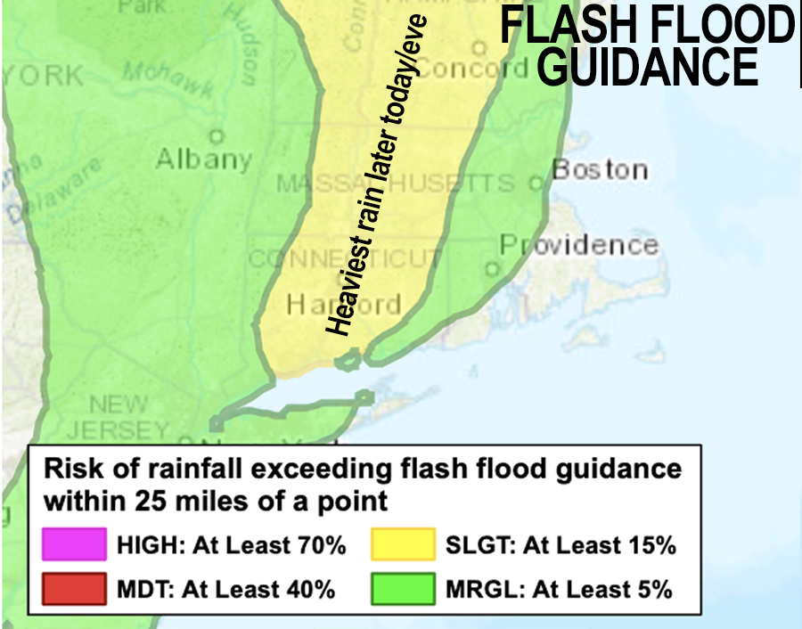
TABLE OF CONTENTS
* Daily Celestials (Sun/Moon Data)
* Sponsor Note
* Join My Newsletter
(& get my Top12WMassStorms ebook!)
* Morning Discussion
* TIP: Scroll below for sections, or read all
~~~~~~~~~~~~~~~~~~~~~~
YOUR DAILY CELESTIALS
~~~~~~~~~~~~~~~~~~~~~~
STAR:
–OUR STAR ROSE AT: 6:02am this morning
–OUR STAR WILL SET AT: 7:44pm this evening
–TOTAL DAYLIGHT TIME: 13 hours and 42 minutes
MOON:
–OUR MOON WILL RISE AT: 8:04pm this evening
–MOON RISE DIRECTION: East-Southeast
–OUR MOON WILL SET AT: 6:51am tomorrow morning
–MOON SET DIRECTION: West-Southwest
–MOON PHASE: Full Sturgeon Moon
~~~~~~~~~~~~~~~~~~~~~~
A NOTE FROM OUR SPONSOR
~~~~~~~~~~~~~~~~~~~~~~
Dave Hayes The Weather Nut is Sponsored by Individual Community Members, Patrons, and Tandem Bagel Company… No matter the weather, Tandem Bagel is always there for you at several valley locations to make your mornings brighter! With *New Pizza Bagels(!)*, along with bagels baked fresh daily (including Gluten-Free options), house-whipped cream cheese, coffee, and tons of lunch options, Tandem is the perfect quick stop for lunch, breakfast, or a coffee and bagel to go.
You can either 1) visit them in Easthampton, Northampton, Hadley, Florence, and/or West Springfield, 2) hire them to cater your next event, or 3) use their super-streamlined online ordering tool by visiting their website and clicking the “Catering” or “Order Online” links.
~~~~~~~~~~~~~~~~~~~~~~
DAVE’S WEEKLY NEWSLETTER (Top 12 WMass Storms)
DAVE’S MOBILE APP (Late 2024 Release)
~~~~~~~~~~~~~~~~~~~~~~
YOUR MORNING DISCUSSION
~~~~~~~~~~~~~~~~~~~~~~
Good morning everybody, it is quite humid and damp outside with dewpoints and air temps in the mid to upper 60s, with patchy fog in spots.
Final overnight showers are exiting eastern CMass and far NE.CT, and an upper level trough is swinging east into our region with a cold front and surface low pressure along it, which likely passes through northern New England later.
We’re mostly cloudy this morning, but am expecting some sunny, humid breaks later by early afternoon which will help bring high temps into the mid 70s to low 80s.
These sunny breaks would increase instability and therefore help to support development chances for severe weather later today between the 3-9pm timeframe form west (MA-NY state line) to east (Worcester-Fitchburg stretch in CMass) as our cold front presses into this humid, fairly unstable air with modest wind shear.
The increased instability would help fuel thunderstorms congealing into a broken or even more solid squall line capable of producing bowing echoes containing isolated strong wind gusts that could produce a few areas of tree damage. Small hail is also possible.
Heavy rain is also expected for some, and this line won’t be moving super fast, so some isolated flash flooding is possible, and/or ponding on roadways.
So we have one more busy day ahead co-existing in our soupy air mass before the front sweeps this mess seaward, ushered in by westerly gusts overnight and into Tuesday of 15-30mph at times, with lows tonight in the 55-60º range.
For Tuesday, I expect a mixed sky day with some lingering morning showers, breezy conditions out of the west, and highs only in the mid 60s to low 70s as drier air sweeps into the region…. WHOOOOOSH!
Weather will be ideal for Performance 34 at the Pines Theatre in Look Memorial Park under the Full Moon Tuesday night, so please come out, sit on the lawn, enjoy great local music, and see yours truly thump the electric bass with some fabulous musicians!
Lows will plummet into the upper 40s to low 50s for a downright chilly mid-August morning Tuesday night, and we may even see some mid 40s in SVT!
Despite our lingering upper low bringing a few clouds or a shower Wednesday on its way off to sea, I am expecting a longer-lasting period of fair weather from Wednesday through the upcoming weekend with plenty of sunshine, dry air through at least the work week, and highs ranging from the 60s to mid 70s through Thursday (with lows either side of 50º), to the 70s to mid 80s through the weekend (with lows mid/upper 50s) as temps increase each day given that high pressure will pass west and then south of New England.
I will dial in specific temp ranges tomorrow, but suffice it to say, very nice weather arrives after whatever mess transpires today across our region, and I will update you by late morning, and then again before 5pm.
Summer is not over, as a warm up may continue into next week, but for now, this soupy messy morass of thundery, flood-y dampness will wane for a while.
Have a great day!
“Follow your bliss and the universe will open doors for you where there were only walls.”
― Joseph Campbell