
TABLE OF CONTENTS
* Daily Celestials (Sun/Moon Data)
* Sponsor Section
* Morning Discussion
* TIP: Scroll to your section, or read all
~~~~~~~~~~~~~~~~~~~~~~
YOUR DAILY CELESTIALS
~~~~~~~~~~~~~~~~~~~~~~
STAR:
–OUR STAR ROSE AT: 6:01am this morning
–OUR STAR WILL SET AT: 7:45pm this evening
–TOTAL DAYLIGHT TIME: 13 hours and 44 minutes
MOON:
–OUR MOON WILL RISE AT: 7:34pm this evening
–MOON RISE DIRECTION: East-Southeast
–OUR MOON WILL SET AT: 5:30am tomorrow morning
–MOON SET DIRECTION: West-Southwest
–MOON PHASE: Waxing Gibbous (97.4%)
~~~~~~~~~~~~~~~~~~~~~~
>>> A NOTE FROM OUR WEEKEND SPONSOR <<<
Dave Hayes The Weather Nut is Sponsored by Individual Community Members, Patrons, and Gerard, Ghazey & Bates, P.C. GGBPC is a Northampton-based law firm regarded as the voice of pragmatic and well-reasoned estate planning, elder law and tax guidance in Western Massachusetts. The firm specializes in estate planning law, and expertly handles other matters such as Elder Law, Tax Law, as well as Real Estate purchase, sales, and refinance transactions. Contact GGBPC today to see how they can help!
~~~~~~~~~~~~~~~~~~~~~~
YOUR MORNING DISCUSSION
~~~~~~~~~~~~~~~~~~~~~~
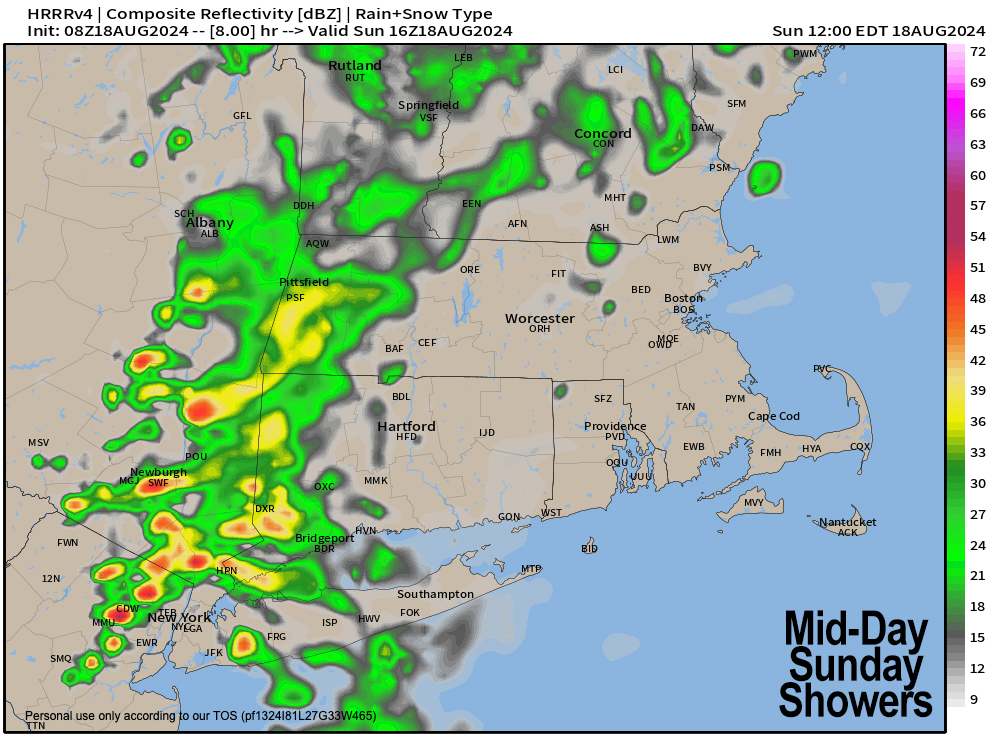
Good morning folks, we’ve got rain showers in various parts of the region this morning, notably CMass, parts of southwest NH, parts of WMass, parts of northern CT and into SVT too.
It’s a showery smorgasbord, try the downpours, they’re delicious.
More showers are tracking north-northeast into our region this morning, so expect a wet morning, with heavy rain at times.
It’ll be humid and highs today will reach the 70s, with a possible lull to isolated showers occasionally during the afternoon at some point. If we get some sunny breaks this afternoon which I expect, we could see some southerly breezes kick up to 20mph gusts or so.
Another shortwave works through the region this evening and tonight with more rain, along with some downpours or a thunderstorm, with a low chance for flash flooding in the southern Berkshires, southern Taconics and northwest CT.
Lows tonight will dip into the mid to upper 60s with humid conditions, patchy fog and some shower activity in spots.
For Monday, our cold front finally approaches the region, set to sweep this soupy morass out to sea.
Highs will reach the mid to upper 70s under mostly cloudy skies, and by afternoon and evening we will see more showers, downpours and thunderstorms developing over the region.
One or two storms may containing strong gusty winds, but a severe threat is not really expected at this time.
Showers should last into the evening, with lows dropping into the 50s as activity becomes more isolated to scattered behind the front.
Tuesday looks to start off with some lingering showers as the upper low will still have to work east through the region.
It looks like partly sunny to mostly cloudy skies will rule, and we can’t rule out an early to mid afternoon shower, but with the cold front trucking east, and sort of getting yanked by Ernesto as it steams out to sea east of St. John’s, Newfoundland, we should be drying into Tuesday night with northwest gusts over 20mph at times and lows dipping into a chilly range of upper 40s to low 50s.
For now, the Wednesday through Saturday period looks much drier, much more pleasant, much sunnier and peaceful with giant high pressure moving into the region.
We will start off cool with highs in the mid 60s to low 70s Wednesday and low to mid 70s Thursday, but by Friday into the weekend highs will climb above 80º again.
I am a little skeptical of Wednesday, as there could be an instability shower that pops with much cooler air aloft, but for now, it looks like haymaking weather is on the way.
Have a great day!
HAIKU OF THE DAY:
We crave certainty
Life never does deliver
Weather follows suit
“Follow your bliss and the universe will open doors for you where there were only walls.”
― Joseph Campbell