
TABLE OF CONTENTS
* Daily Celestials (Sun/Moon Data)
* Sponsor Note
* Join My Newsletter
(& get my Top12WMassStorms ebook!)
* Morning Discussion
* TIP: Scroll below for sections, or read all
~~~~~~~~~~~~~~~~~~~~~~
YOUR DAILY CELESTIALS
~~~~~~~~~~~~~~~~~~~~~~
STAR:
–OUR STAR ROSE AT: 5:55am this morning
–OUR STAR WILL SET AT: 7:54pm this evening
–TOTAL DAYLIGHT TIME: 13 hours and 59 minutes
MOON:
–OUR MOON WILL SET AT: 11:23pm tonight
–MOON SET DIRECTION: Southwest
–OUR MOON WILL RISE AT: 3:09pm tomorrow afternoon
–MOON RISE DIRECTION: Southeast
–MOON PHASE: Waxing Gibbous (48.3%)
~~~~~~~~~~~~~~~~~~~~~~
A NOTE FROM OUR SPONSOR
~~~~~~~~~~~~~~~~~~~~~~
Dave Hayes The Weather Nut is Sponsored by Individual Community Members, Patrons, and Tandem Bagel Company… No matter the weather, Tandem Bagel is always there for you at several valley locations to make your mornings brighter! With *New Pizza Bagels(!)*, along with bagels baked fresh daily (including Gluten-Free options), house-whipped cream cheese, coffee, and tons of lunch options, Tandem is the perfect quick stop for lunch, breakfast, or a coffee and bagel to go.
You can either 1) visit them in Easthampton, Northampton, Hadley, Florence, and/or West Springfield, 2) hire them to cater your next event, or 3) use their super-streamlined online ordering tool by visiting their website and clicking the “Catering” or “Order Online” links.
~~~~~~~~~~~~~~~~~~~~~~
DAVE’S WEEKLY NEWSLETTER (Top 12 WMass Storms)
DAVE’S MOBILE APP (Late 2024 Release)
~~~~~~~~~~~~~~~~~~~~~~
YOUR MORNING DISCUSSION
~~~~~~~~~~~~~~~~~~~~~~
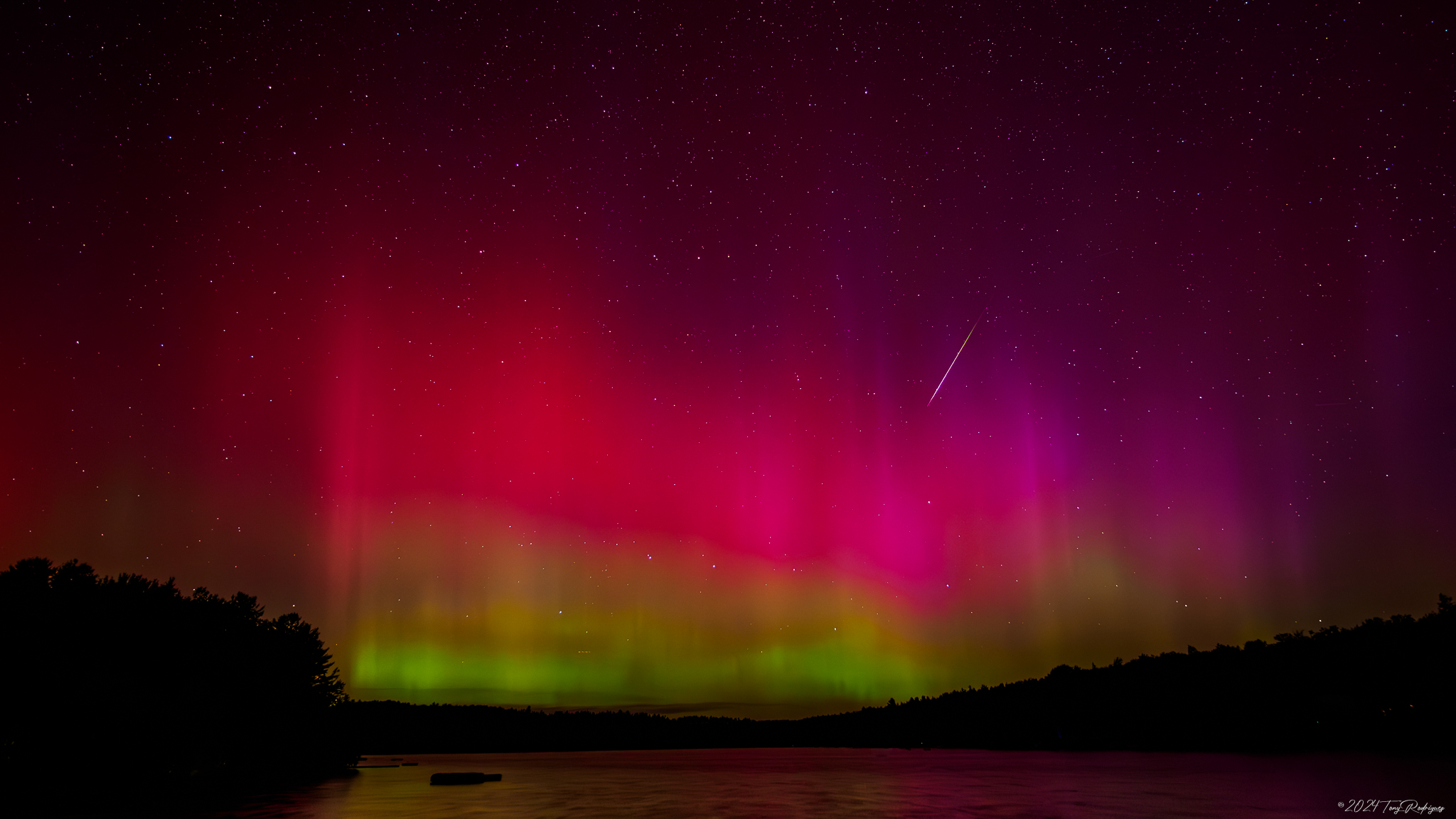
Good morning folks, who saw the Aurora last night? I did not realize that the Kp Index could pin up to 7, which is usually the minimum number for a more widespread southern New England Northern Lights event (earlier this year the Kp hit a 9, for example).
I have seen a number of photos (including the attached by Tony Rodriguez taken in Goshen, MA last night), and if you have some, please post below.
Any Perseids viewings? Let me know.
As for our weather, it’s pretty pedestrian this week, with lots of lower humidity and dry conditions, though the exception for some will be this afternoon and Thursday afternoon and evening with scattered showers or a thunderstorm or two possible.
For today, highs should reach square into the 70s, with a couple of 80º readings possible under mostly sunny skies early, and more partly sunny skies later, dotted with cumulus clouds as a shortwave rotates through the region.
This will help fire some scattered showers and a thunderstorm or two, but not everyone will get wet.
I can’t rule out some small hail either, given much colder mid level temperatures moving overhead, and of course, any storm with a wave blowing through can produce a strong gusty wind, in addition to the more broad west-northwest gusts of 15-25mph expected today.
Everything dies down tonight under clearing skies with lows in the low to mid 50s.
For Tuesday and Wednesday, high pressure builds into the region from the southwest with increasing sunshine and highs in the mid 70s to low 80s Tuesday and the upper 70s to mid 80s on Thursday with lows in the 50s, and dewpoints in the 50s to near 60º, so it will be lovely summer weather.
By Thursday, another wave rolls through, but doesn’t look like a big deal, other than some scattered showers with a thunderstorm possible in the afternoon, and highs similar to Wednesday with lows near 60º.
Friday provides a respite between systems with sunshine and highs in the low to mid 80s, and the we turn to the weekend into early next week which carries some uncertainty with it based on the progression and position of a frontal boundary and associated low pressure near the Great Lakes.
It looks like we should expect for now to be dealing with some showery periods at some point over the weekend into early next week, but I’ll need to get closer to parse out all of those details of impacts, timing, etc.
Temps certainly look to remain seasonable, with no big heat or humidity surges that I can see at the moment.
Hopefully what will become Ernesto in the tropics will be shunted seaward and away from New England by early next week.
Have a great day, and remember that I’m taking tomorrow off as it looks as calm, seasonably warm, and sunny as can be!
“Follow your bliss and the universe will open doors for you where there were only walls.”
― Joseph Campbell