
TABLE OF CONTENTS
* Daily Celestials (Sun/Moon Data)
* Sponsor Note
* Join My Newsletter
(& get my Top12WMassStorms ebook!)
* Morning Discussion
* TIP: Scroll below for sections, or read all
~~~~~~~~~~~~~~~~~~~~~~
YOUR DAILY CELESTIALS
~~~~~~~~~~~~~~~~~~~~~~
STAR:
–OUR STAR ROSE AT: 5:51am this morning
–OUR STAR WILL SET AT: 7:59pm this evening
–TOTAL DAYLIGHT TIME: 14 hours and 8 minutes
MOON:
–OUR MOON WILL SET AT: 9:55pm tonight
–MOON SET DIRECTION: West
–OUR MOON WILL RISE AT: 10:51am tomorrow morning
–MOON RISE DIRECTION: East
–MOON PHASE: Waxing Crescent (14.3%)
~~~~~~~~~~~~~~~~~~~~~~
A NOTE FROM OUR SPONSOR
~~~~~~~~~~~~~~~~~~~~~~
Dave Hayes The Weather Nut is Sponsored by Individual Community Members, Patrons, and Tandem Bagel Company… No matter the weather, Tandem Bagel is always there for you at several valley locations to make your mornings brighter! With *New Pizza Bagels(!)*, along with bagels baked fresh daily (including Gluten-Free options), house-whipped cream cheese, coffee, and tons of lunch options, Tandem is the perfect quick stop for lunch, breakfast, or a coffee and bagel to go.
You can either 1) visit them in Easthampton, Northampton, Hadley, Florence, and/or West Springfield, 2) hire them to cater your next event, or 3) use their super-streamlined online ordering tool by visiting their website and clicking the “Catering” or “Order Online” links.
~~~~~~~~~~~~~~~~~~~~~~
DAVE’S WEEKLY NEWSLETTER (Top 12 WMass Storms)
DAVE’S MOBILE APP (Late 2024 Release)
~~~~~~~~~~~~~~~~~~~~~~
YOUR MORNING DISCUSSION
~~~~~~~~~~~~~~~~~~~~~~
Good morning everybody, we have to get through whatever Debby’s remnants will throw our way tonight, tomorrow, and especially tomorrow night before we enter what looks to be a truly glorious, refreshing, and much needed pattern change to lower humidity, sunnier, drier stretch of weather from Saturday afternoon through Sunday and into the middle of next week, so hang in there!
As for our weather for today through Saturday morning, it’s been a long long time, but The Bulletization Mobile(TM) has been in my ears, up my nostrils and down my throat honking away, alerting to me the fact that a double-dashed bulletization presentation is appropriate for this morning — it’s actually been quite rude and disruptive, but I get it… point taken!!
SUMMAH-RY
–Patchy fog this morning will burn off by 8am or 9am
–Temps in the 50s will climb up into the upper 60s to mid 70s
–Any early sunshine will be replaced by increasing clouds
–A burst of more humid air will begin to surge north into our in situ dry air thanks to Maine high pressure
–Said high pressure will slowly drift east through today and overnight, clearing the way for much more humid air to surge north
–First showers will arrive with this surge by mid to late afternoon, or this evening, depending where you are in the region (sooner south, later north)
–Scattered showers continue tonight as humidity increases, with lows in the low 60s, and patchy fog will develop
–For Friday, this is our storm day
–Much of the morning through mid to perhaps late afternoon features scattered showers, with some downpours or a rumble of thunder, and dry periods too
–Humidity will spike with dewpoints in the 70s
–Highs will rise into the mid to upper 70s
–Debby’s remnant low center will be extratropical and speeding up as it tracks north-northeast into central PA and east-central NY headed for northern VT overnight into the pre-dawn hours of Saturday
–As this happens, winds will become breezy, gusting 20-30mph in most areas
–At night, gusts could reach 30-45mph in the Berkshires, western hilltowns, southern Greens and Taconics as the low level jet streak passes overhead
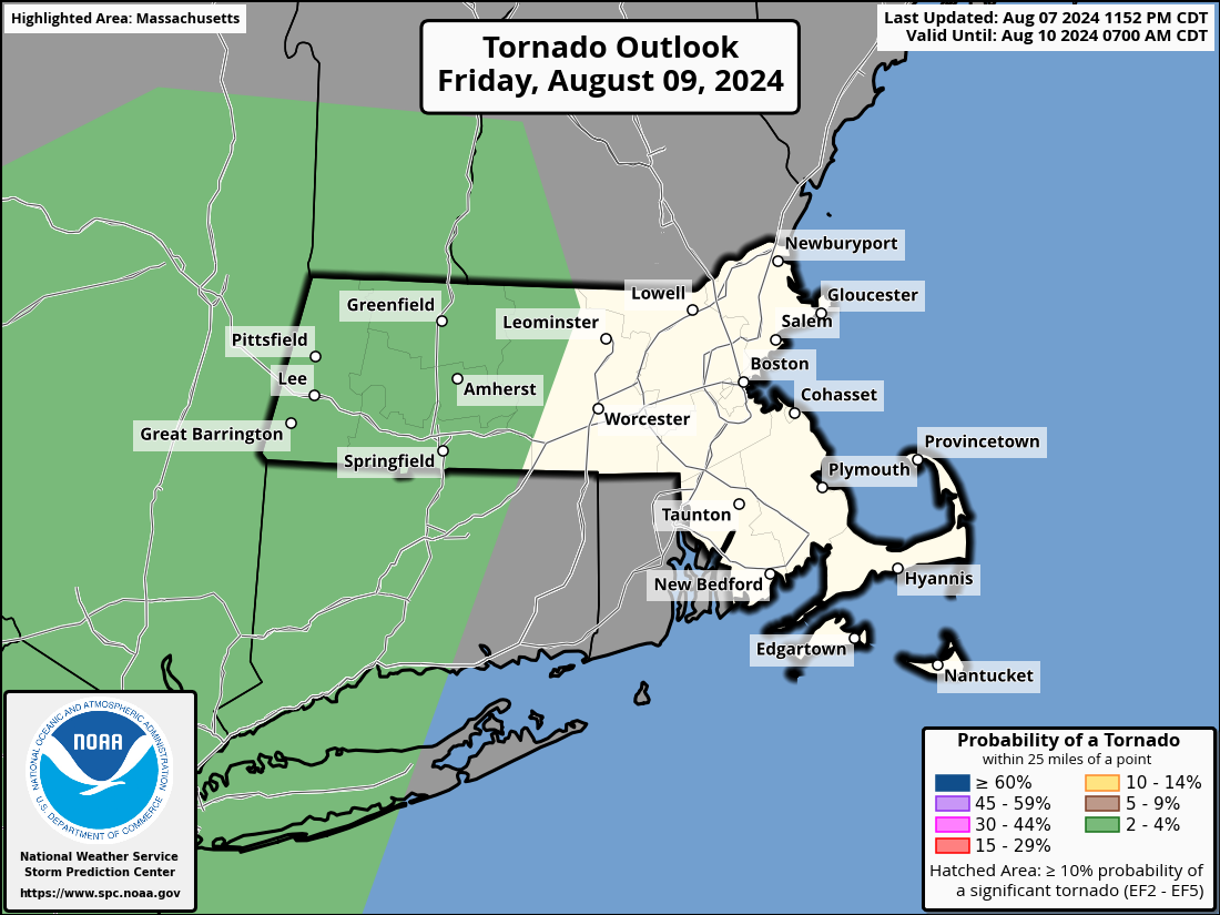
–In addition, there will be a low level turning of the air sweeping through, and a tornado or two are possible, but would be weak and brief, if they do form
–Showers, downpours and thunderstorms swing through Friday night representing the brunt of this system for us, but I think most rainfall totals will be 1-3″ west of the CT River, and .5-1.5″ east of there
–Street flooding is possible, and perhaps an isolated flash flood instance in SVT, or the Berkshires late Friday night
–Lows will be warm, only in the mid 60s to low 70s as tropical air surges through
–On Saturday morning, any remnant showers whisk away to the northeast, and clouds turn to partial to full sunshine with west winds gusting over 25mph at times as a new air mass starts being pulled in behind Debby’s departure
–Highs will be warm, into the mid 70s to low 80s with humid air slowly being pulled away
–Lows Saturday night will dip into the mid to upper 50s under clear skies and drying air
–Sunday through Wednesday look FABULOUS right now, with a whole new air mass, and highs in the 70s, lows in the 50s, and plenty of sun and peaceful conditions
Have a great day and I will keep you updated!
“Follow your bliss and the universe will open doors for you where there were only walls.”
― Joseph Campbell