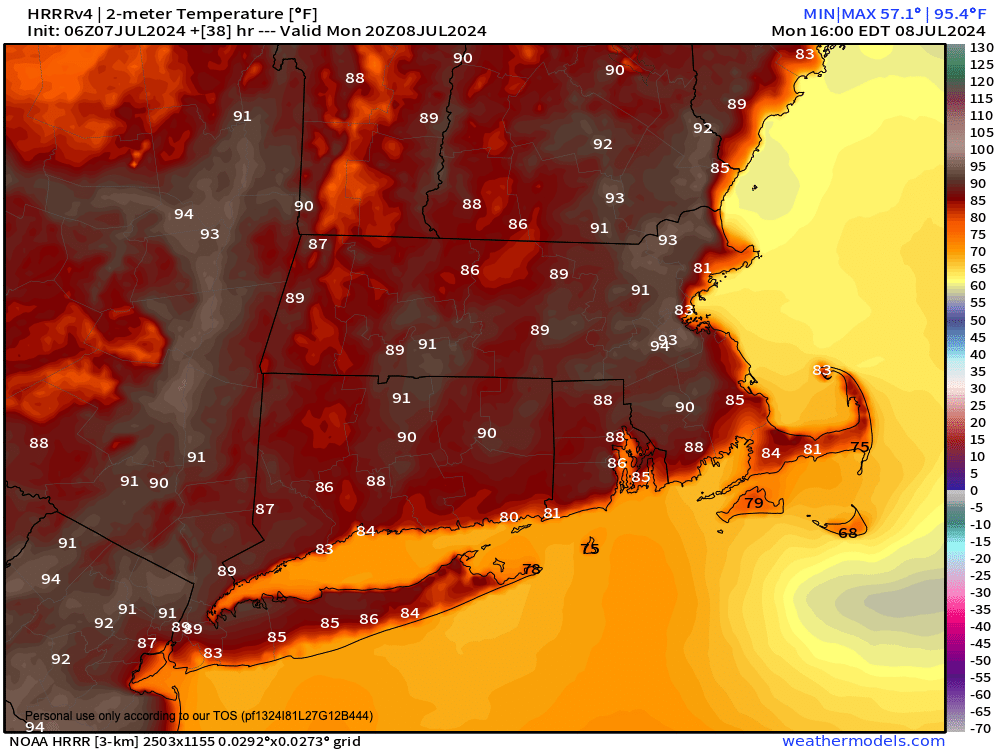
[8:20AM SUN: 7/7/24] VERY WARM TO HOT AND HUMID CONDITIONS PERSIST THROUGH THE WEEK… POTENTIAL BORDERLINE HEAT WAVE FOR TODAY THROUGH TUESDAY… SLIGHT TAMP IN HUMIDITY TODAY AND TOMORROW, BUT HIGH LEVELS RETURN TUESDAY THROUGH THE END OF THE WEEK… SUNNIER TODAY AND TOMORROW, SHOWER/STORM CHANCES RESUME TUESDAY AFTERNOON AND WEDNESDAY, FOLLOWED BY BERYL’S RAINY REMNANTS LATE WEEK… BEHIND TROPICAL SYSTEMS WE CAN GET PATTERN CHANGES, WE SHALL SEE…

TABLE OF CONTENTS
* Daily Celestials (Sun/Moon Data)
* Sponsor Section
* Morning Discussion
* TIP: Scroll to your section, or read all
~~~~~~~~~~~~~~~~~~~~~~
YOUR DAILY CELESTIALS
~~~~~~~~~~~~~~~~~~~~~~
STAR:
–OUR STAR ROSE AT: 5:22am this morning
–OUR STAR WILL SET AT: 8:28pm this evening
–TOTAL DAYLIGHT TIME: 15 hours and 6 minutes
MOON:
–OUR MOON WILL SET AT: 10:08pm this afternoon
–MOON SET DIRECTION: West-Northwest
–OUR MOON WILL RISE AT: 7:49am tomorrow morning
–MOON RISE DIRECTION: East-Northeast
–MOON PHASE: Waxing Crescent (2.8%)
~~~~~~~~~~~~~~~~~~~~~~
>>> A NOTE FROM OUR WEEKEND SPONSOR <<<
Dave Hayes The Weather Nut is Sponsored by Individual Community Members, Patrons, and Gerard, Ghazey & Bates, P.C. GGBPC is a Northampton-based law firm regarded as the voice of pragmatic and well-reasoned estate planning, elder law and tax guidance in Western Massachusetts. The firm specializes in estate planning law, and expertly handles other matters such as Elder Law, Tax Law, as well as Real Estate purchase, sales, and refinance transactions. Contact GGBPC today to see how they can help!
~~~~~~~~~~~~~~~~~~~~~~
YOUR MORNING DISCUSSION
~~~~~~~~~~~~~~~~~~~~~~
Good morning folks, thanks for all of the reports yesterday. As you know by this point in your lives, these summer instability small-scale shower/downpour/storm days are a story of haves and have nots.
They are not rainstorms that blanket a region, just tiny cells, sometimes larger clusters that wet the ground in one part of town, and leave the other dry.
As for today, while there’s a very low chance for a shower or thunderstorm in southeast Worcester County down into northeast CT, most of us will see increasing sunshine and this should last into Tuesday.
We still have a giant Bermuda and east-of-Bermuda high pressure system that will encourage southwest flow producing heat and humidity into New England all week long.
Because a cold front came through we’ll get a slight break today and tomorrow, but it will still be humid overall, with oppressive levels of humidity returning by Monday night into Tuesday.
Highs should crest into the mid 80s to low 90s today, tomorrow and Tuesday (with lows in the 60s to near 70º each night), which means some of us will get a sneaky surprise borderline heat wave, most likely in the southern Pioneer Valley of Hampden County down into the Hartford stretch.
So, we’ll see partly to mostly sunny skies today, mostly sunny tomorrow, and partly sunny Tuesday morning, with clouds increasing by afternoon as a shortwave approaches the region.
We could see heat indices rise above the mid 90s over the next 3 days, so if you have respiratory issues or otherwise do poorly in higher heat and humidity, you should take it east through Tuesday at the very least.
Tuesday and Wednesday will see a resumption of very high levels of humidity with dewpoints in the 70s, as well as some waves of energy that will bring a renewed period of showers, downpours and thunderstorms, scattered about the regioin.
Highs should reach the 80s Wednesday through Friday, with lows in the mid 60s to low 70s.
By Thursday and Friday we’ll have to watch the exact track of the rainy (not windy) remnants of Tropical Cyclone Beryl, which will likely pass through New York state to our west.
This could enhance the chance for heavier rainfall in the late week period, but we need to get closer to see how it shakes out.
Hopefully by the following weekend we’ll get some more sunshine back into the region, and we have to remember that tropical systems can shift patterns, though because Beryl will be riding the northwest flank of a large Bermuda high pressure system, it may just reinforce our heat and humidity into the middle of July.
We shall see… have a great day!
HAIKU OF THE DAY:
Skin-sticking moisture
Always a form of torture
Nut lives in basement
“Follow your bliss and the universe will open doors for you where there were only walls.”
― Joseph Campbell
