
TABLE OF CONTENTS
* Daily Celestials (Sun/Moon Data)
* Sponsor Section
* Morning Discussion
* TIP: Scroll to your section, or read all
~~~~~~~~~~~~~~~~~~~~~~
YOUR DAILY CELESTIALS
~~~~~~~~~~~~~~~~~~~~~~
STAR:
–OUR STAR ROSE AT: 5:21am this morning
–OUR STAR WILL SET AT: 8:28pm this evening
–TOTAL DAYLIGHT TIME: 15 hours and 7 minutes
MOON:
–OUR MOON WILL SET AT: 9:35pm this afternoon
–MOON SET DIRECTION: Northwest
–OUR MOON WILL RISE AT: 6:41am tomorrow morning
–MOON RISE DIRECTION: Northeast
–MOON PHASE: Waxing Crescent (0.4%)
~~~~~~~~~~~~~~~~~~~~~~
>>> A NOTE FROM OUR WEEKEND SPONSOR <<<
Dave Hayes The Weather Nut is Sponsored by Individual Community Members, Patrons, and Gerard, Ghazey & Bates, P.C. GGBPC is a Northampton-based law firm regarded as the voice of pragmatic and well-reasoned estate planning, elder law and tax guidance in Western Massachusetts. The firm specializes in estate planning law, and expertly handles other matters such as Elder Law, Tax Law, as well as Real Estate purchase, sales, and refinance transactions. Contact GGBPC today to see how they can help!
~~~~~~~~~~~~~~~~~~~~~~
YOUR MORNING DISCUSSION
~~~~~~~~~~~~~~~~~~~~~~
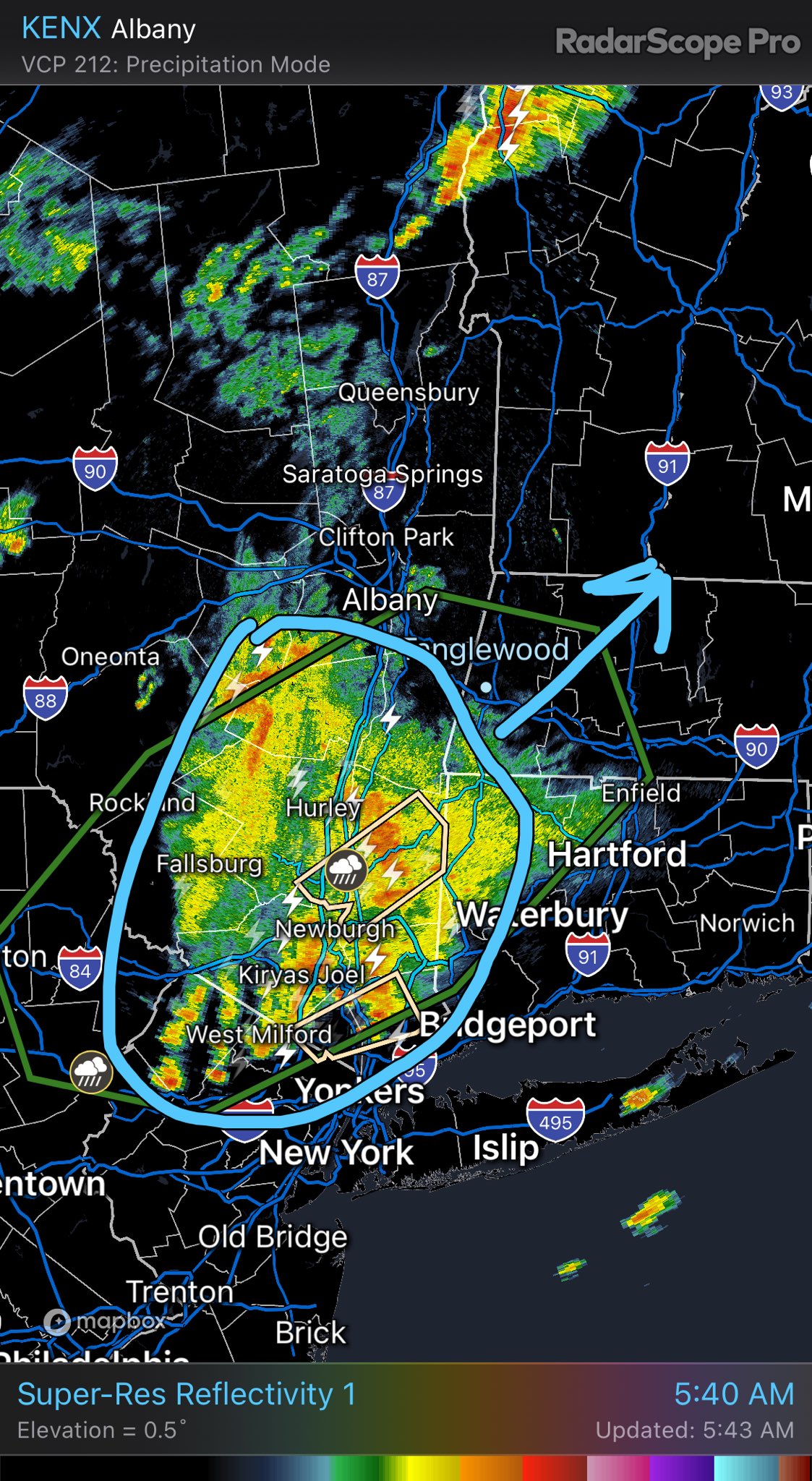
Good morning folks, we have active weather moving into the region this morning, already impacting the Berkshires and northwest CT as a mesoscale convective complex (i.e. an old cluster of thunderstorms that survived overnight from PA/MD) is tracking northeast into our neck of the woods and waking some folks up early.
This system is acting on high moisture content and instability, and also will be aided by orographic uplift, which refers to how the presence of mountains in the WMass region forces air to rise, which increases precipitation rates.
All this to say, very heavy rain is possible for some and we can’t rule out localized areas of flash flooding or street flooding.
This system will track through the region, but very humid conditions will continue as the final cold front will come through late today.
That means additional scattered showers, downpours and thunderstorms will be possible, though severe weather is not expected, just heavy rainfall at times.
Highs will reach the low to mid 80s today under mostly cloudy skies, with lows in the 60s, and it will be very uncomfortable with high humidity.
For Sunday, we start to dry out behind the front, and while an isolated shower or storm is possible, we should enjoy a mostly sunny day with highs in the 80s to 90º with dewpoints in the 60s.
As lows settled down to the mid 60s overnight, patchy fog will be possible, otherwise we should see mostly clear skies.
Monday looks like a true summer day with highs in the mid 80s to low 90s, and quite humid, so I wouldn’t be surprised if a few short-leashed Heat Advisories are hoisted for a day.
Skies will be mostly sunny and lows will dip into the mid to upper 60s.
Once we get to the Tuesday to Friday timeframe, we are entering into another unsettled period.
Tuesday morning should be dry, but clouds will be building as another frontal boundary and associated upper low will be approaching from the west.
This will help to develop increasing shower and thunderstorm activity to act on increasing humidity by afternoon or night time.
Highs should climb into the 85-90º range, with lows 65-70º and continued shower activity.
Between Wednesday and Friday we may see a lull by Wednesday night into Thursday, but then we are watching the rainy moist remnants (not the windy remnants) of Tropical Cyclone Beryl, which will be likely tracking northwest of us through PA and NY, but that could introduce a heavy rain threat.
Highs will be in the 80s and lows will be in the 60s, and humidity will persist, but I will parse out the details of that next-week period as we get closer to it.
Have a great day, and be alert to the incoming weather this early morning, and post any reports below, thanks!
HAIKU OF THE DAY:
Soup ingredients
We’re sadly swimming in it
Dreaming of Autumn
“Follow your bliss and the universe will open doors for you where there were only walls.”
― Joseph Campbell