
~~~~~~~~~~~~~~~~~~~~~~
TABLE OF CONTENTS
* Daily Celestials (Sun/Moon Data)
* Sponsor Section
* Morning Discussion
* TIP: Scroll to your section, or read all
~~~~~~~~~~~~~~~~~~~~~~
YOUR DAILY CELESTIALS
~~~~~~~~~~~~~~~~~~~~~~
STAR:
–OUR STAR ROSE AT: 5:17am this morning
–OUR STAR WILL SET AT: 8:30pm this evening
–TOTAL DAYLIGHT TIME: 15 hours and 13 minutes
***Peak Light!***
MOON:
–OUR MOON WILL SET AT: 1:57pm this afternoon
–MOON SET DIRECTION: West
–OUR MOON WILL RISE AT: 1:09am tomorrow morning
–MOON RISE DIRECTION: East
–MOON PHASE: Waning Crescent (43.8%)
~~~~~~~~~~~~~~~~~~~~~~
>>> A NOTE FROM OUR WEEKEND SPONSOR <<<
Dave Hayes The Weather Nut is Sponsored by Individual Community Members, Patrons, and Gerard, Ghazey & Bates, P.C. GGBPC is a Northampton-based law firm regarded as the voice of pragmatic and well-reasoned estate planning, elder law and tax guidance in Western Massachusetts. The firm specializes in estate planning law, and expertly handles other matters such as Elder Law, Tax Law, as well as Real Estate purchase, sales, and refinance transactions. Contact GGBPC today to see how they can help!
~~~~~~~~~~~~~~~~~~~~~~
YOUR MORNING DISCUSSION
~~~~~~~~~~~~~~~~~~~~~~
Good morning folks, we’ve had some light intermittent shower development already this morning with a few spots picking up hundredths of an inch, which is fairly negligible.
A warm front will continue to approach our area today and pass through tonight, which will produce a mostly cloudy day with highs in the 70-75º range.
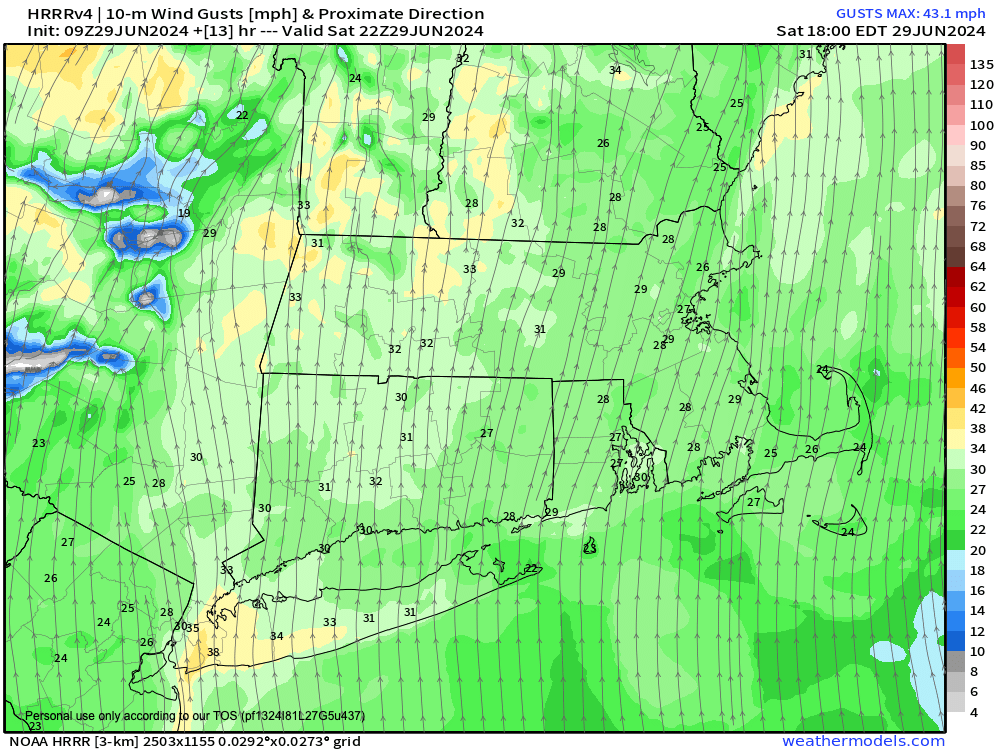
Some southerly breezes should come up by afternoon, gusting 20-30mph at times as the front approaches, and while isolated to scattered mainly-lighter showers should intersperse with dry periods today, once we get past the 4-6pm timeframe, especially west of the I-91 corridor, rain showers will pick up in number and an intensity.
In fact, some downpours and thunderstorms will be possible after about 8pm through the overnight period, but any storms should not be severe as the warm front passes through.
Temperatures will drop very little from today’s cooler high temps, only dropping into the mid to upper 60s as humidity surges overnight, and as that happens, patchy fog will likely form.
The warm front will pass through overnight, and then as early morning showers and the front clears the region, we’ll enter the pre-frontal trough zone ahead of an incoming cold front.
This should allow temps to come up well into the 80s as partial sunshine develops, and possibly full sunshine for a time in the later morning period toward mid-day.
Our incoming cold front will carry with it strong wind shear (i.e. the change of wind speed and/or direction, with height from surface to sky), and will pass through the region around dinner time or so.
However, as the front approaches it will press upon that very warm, very humid and destabilizing air mass in place around mid day, and cause the development of scattered strong to severe thunderstorms, which will be congealing into a squall line (or the technical term, QLCS, or Quasi-Linear Convective System).
The most potent storm potential moves through from about Noon to 5pm from northwest to southeast (the direction the line will travel), and could produce damaging wind gusts and hail, along with heavy rain and frequent lightning. I can’t even rule out a quick, weak tornado.
Highs will climb well into the 80s, with dewpoints in the low to mid 70s, and a secondary line with the actual front may kick up more downpours and thunderstorms as it swings through around dinner time or so.
This will introduce drier air into the region for Sunday night, with lows in the mid to upper 50s.
Fro Monday, a few lingering isolated showers or a t-storm is possible, but we should be seeing high pressure working east from our west, and continuing to dry out our region.
Highs should reach the upper 60s to mid 70s under partly sunny skies, with lows dropping into the low to mid 50s with a clear night expected.
High pressure really sinks into the region Tuesday and Wednesday with mostly sunny days expected and highs in the mid 70s to low 80s, with lows in the 50s Tuesday night and low to mid 60s Wednesday night as another frontal boundary approaches.
The 4th of July itself looks like much warmer and more humid day with a chance for some shower activity and highs in the 80s, with more showers and a few thunderstorms possible by Friday as a frontal boundary may get hung up near our region.
HAIKU OF THE DAY:
Instability
Energy bubbling, growing
Life goes up and down
Have a great day!
“Follow your bliss and the universe will open doors for you where there were only walls.”
― Joseph Campbell