
~~~~~~~~~~~~~~~~~~~~~~
TABLE OF CONTENTS
* Daily Celestials (Sun/Moon Data)
* Sponsor Note
* Join My Newsletter (& get my Top12WMassStorms ebook!)
* Morning Discussion
* TIP: Scroll below for sections, or read all
~~~~~~~~~~~~~~~~~~~~~~
YOUR DAILY CELESTIALS
~~~~~~~~~~~~~~~~~~~~~~
STAR:
–OUR STAR ROSE AT: 5:16am this morning
–OUR STAR SETS AT: 8:30pm this evening
–TOTAL DAYLIGHT TIME: 15 hours and 14 minutes
*Peak Light*
MOON:
–OUR MOON SETS AT: 10:13am this morning
–MOON SET DIRECTION: West-Southwest
–OUR MOON RISES AT: 12:01am tomorrow morning
–MOON RISE DIRECTION: East-Southeast
–MOON PHASE: Waning Gibbous (77.0%)
~~~~~~~~~~~~~~~~~~~~~~
A NOTE FROM OUR SPONSOR
~~~~~~~~~~~~~~~~~~~~~~
Dave Hayes The Weather Nut is Sponsored by Individual Community Members, Patrons, and Tandem Bagel Company… No matter the weather, Tandem Bagel is always there for you at several valley locations to make your mornings brighter! With *New Pizza Bagels(!)*, along with bagels baked fresh daily (including Gluten-Free options), house-whipped cream cheese, coffee, and tons of lunch options, Tandem is the perfect quick stop for lunch, breakfast, or a coffee and bagel to go.
You can either A) visit them in Easthampton, Northampton, Hadley, Florence, and/or West Springfield, B) hire them to cater your next event, or C) use their super-streamlined online ordering tool by visiting their website and clicking the “Catering” or “Order Online” links.
~~~~~~~~~~~~~~~~~~~~~~
GET DAVE’S TOP 12 MOST POTENT STORMS
IN WMASS HISTORY (Plus 3 honorable mentions)
Grab my detailed (and free) 70-page local storm book filled with storm histories, personal stories, and impacts/facts when you sign up for my free weekly newsletter called “The Nutletter” by clicking this link to my secure website.
~~~~~~~~~~~~~~~~~~~~~~
YOUR MORNING DISCUSSION
~~~~~~~~~~~~~~~~~~~~~~
Good morning everybody, we’re starting off quite warm but also with lower dewpoint temps in the 50s, so it’s a pleasantly warm beginning to our Wednesday.
We’ve got some energy gathering to our west in the form of an upper low and trough near the Great Lakes, which will cast a pre-frontal trough through our region this afternoon.
This will occur as dewpoints come up into the 60s, and high temps are expected to rise into the mid 80s to low 90s today, so hot and humid is on the way for a day.
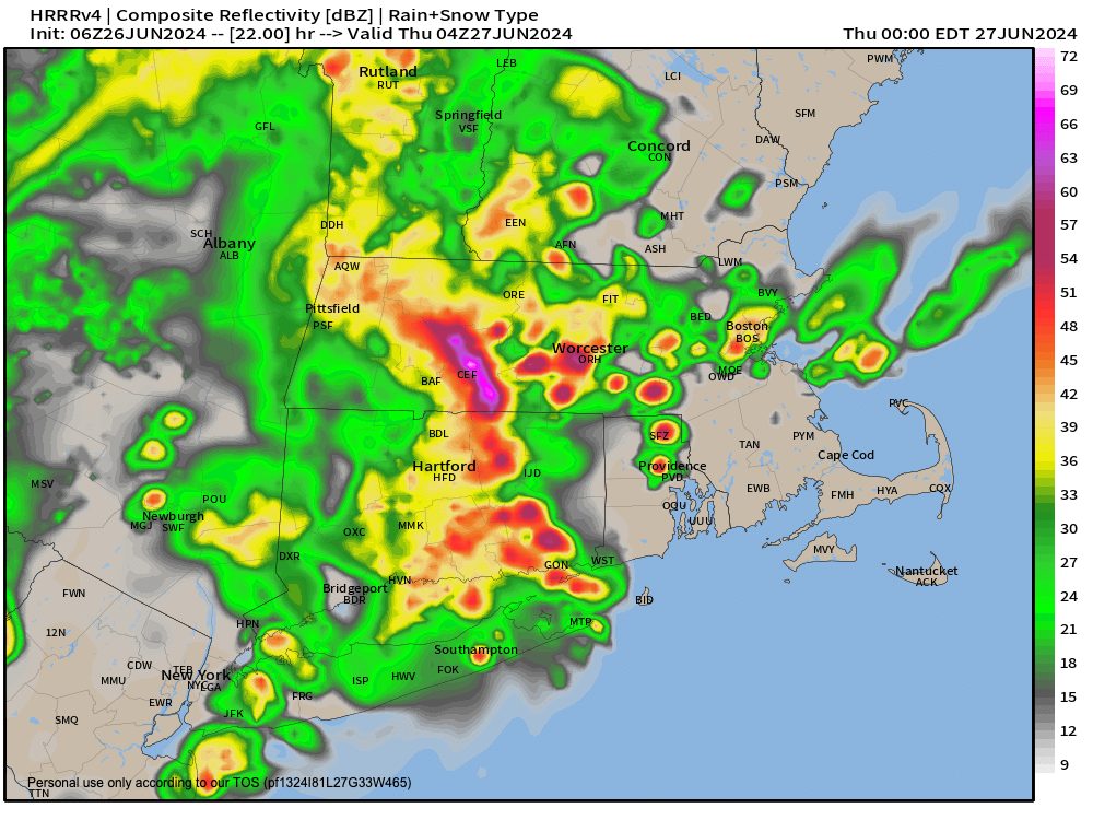
By afternoon, the potential is there for increasing humidity to interact with some other parameters to pop a few isolated showers and thunderstorms, and we can’t rule out a storm becoming strong or severe with wind being the main threat.
More likely, however, is that the isolated showers and storms hold off until very late afternoon or this evening ahead of an incoming large cluster of showers and night time thunderstorms expected to roll through overnight.
Some of these storms could contain some gusty wind with them, but I think the heavy rain threat is more the issue, and if things really come together, we could see some street flooding tonight or even an isolated flash flooding instance, though that’s a low chance for now.
If you like a Night Time Light Show (my new band name, by the way), tonight may be your night!
Lows dip into the low to mid 60s, and then after a few early morning Thursday showers, the day improves with drier air working into the region behind tonight’s cold frontal passage.
I expect a partly sunny day tomorrow on average, as some isolated showers may work through as the upper low passes our longitude, but it will feature lower humidity overall and highs in the upper 70s to low 80s with delicious lows in the low to mid 50s, yum!
Friday is the pick of the week if you ask me: Sunny, dry, very low humidity with dewpoints in the 40s(!) and highs in the mid to upper 70s. I’ll take those days all day long. Lows will drop to tohe 50s again.
Then on Saturday the seesaw goes back up as humidity starts to increase ahead of another frontal boundary, that this time will take 24 hours to cross the region.
We might see a nice sunrise Saturday morning, but clouds will build pretty quickly, and it should be a mostly cloudy day with highs either side of 80º.
Showers will move in by mid to late afternoon, with more rain and a few thunderstorms in the evening and overnight period.
Humidity will come up, and temps, too, with lows in the mid to upper 60s and highs on Sunday in the mid 80s.
Showers will continue into Sunday and it will be quite humid, and a few thunderstorms will be possible, with showers possibly persisting into SunDay’s SunSet.
Thereafter, a cold front moves through and we dry out for early next week with sunshine and highs again either side of 80º with low humidity and lows in the 50s.
So, we’ve got a couple of showery/thundery/muggy periods coming up today/tonight and again Saturday night into Sunday but they’re interspersed with cooling temps, and drier air masses. Hooray!
Have a great day!
>>> BE KIND <<<
“Hello babies. Welcome to Earth. It’s hot in the summer and cold in the winter. It’s round and wet and crowded. On the outside, babies, you’ve got a hundred years here. There’s only one rule that I know of, babies: Goddamn it, you’ve got to be kind.”
–Kurt Vonnegut