
~~~~~~~~~~~~~~~~~~~~~~
TABLE OF CONTENTS
* Daily Celestials (Sun/Moon Data)
* Sponsor Section
* Morning Discussion
* TIP: Scroll to your section, or read all
~~~~~~~~~~~~~~~~~~~~~~
YOUR DAILY CELESTIALS
~~~~~~~~~~~~~~~~~~~~~~
STAR:
–OUR STAR ROSE AT: 5:15am this morning
–OUR STAR WILL SET AT: 8:30pm this evening
–TOTAL DAYLIGHT TIME: 15 hours and 15 minutes
***Peak Light!***
MOON:
–OUR MOON WILL RISE AT: 10:30pm tonight
–MOON RISE DIRECTION: Southeast
–OUR MOON WILL SET AT: 7:38am tomorrow morning
–MOON SET DIRECTION: Southwest
–MOON PHASE: Waning Gibbous (97.3%)
~~~~~~~~~~~~~~~~~~~~~~
>>> A NOTE FROM OUR WEEKEND SPONSOR <<<
Dave Hayes The Weather Nut is Sponsored by Individual Community Members, Patrons, and Gerard, Ghazey & Bates, P.C. GGBPC is a Northampton-based law firm regarded as the voice of pragmatic and well-reasoned estate planning, elder law and tax guidance in Western Massachusetts. The firm specializes in estate planning law, and expertly handles other matters such as Elder Law, Tax Law, as well as Real Estate purchase, sales, and refinance transactions. Contact GGBPC today to see how they can help!
~~~~~~~~~~~~~~~~~~~~~~
YOUR MORNING DISCUSSION
~~~~~~~~~~~~~~~~~~~~~~
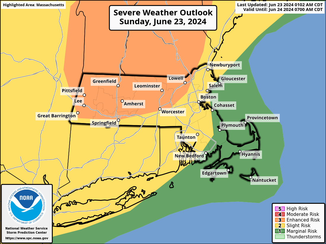
Good morning folks, we have a different severe weather threat today compared to yesterday and the day before.
Those days ended up seeing storms congealing into squall lines or long areas of torrential downpours with wind and hail cores that caused sporadic wind damage, large hail, and areas of flooding.
For today, we have a Level 3 out of 5 severe weather risk from the Storm Prediction Center out of Norman, OK (also called “Enhanced”) and that means that a number of strong to severe thunderstorms are possible with potential for localized straight line wind damage, hail, flooding (though storms move quickly today, so less of a threat compared to previous days) and one or two tornadoes.
I am going to bullet out setup of the day’s progression and timing (onset and exit rough times) for our severe weather potential today.
SETUP
We’re starting off with patchy fog, particularly dense over CMass, and that will lift with time this morning.
It’s cool and humid out, but our warm front is already lifting north and east due to the eastward track of said warm front’s parent low pressure system heading through the eastern Great Lakes and bound for northern New England later today.
This is expected to sweep a warm sector of the storm passing to our north into the greater WMass region by late morning into early afternoon.
We are likely to see partial sunshine develop by this time, and assuming this happens, it will heat the surface, and bring temps up well into the 80s, possibly the upper 80s and even a few lower 90s in the southern valley.
With copious humidity, this will destabilize the surface atmosphere, steepening the temperature gradient from surface to sky, and allowing air to rise more freely (a/k/a low level lapse rate).
Meanwhile, as the storm north of us tracks east, it will sweep stronger lower and mid level winds over the region, and we should see southwest wind gusts come up to 20-35mph at times.
Basically, we want to see little to no sun today to tamp down the severe weather threat.
Regardless, between the low to mid level wind shear, stronger low level lapse rates, high humidity, and increased instability along with a trough moving into the region this afternoon to initiate rising air motions, we are expected to see scattered strong to severe thunderstorms, and possibly a supercell or two.
IMPACTS
These storms could produce any hazard: damaging straight line winds, hail, street flooding (flash flooding is a low chance), and a tornado or two.
TIMING
The timing of this activity could move into the Berkshires, southwest VT and/or western CT as early as 3pm, but I think onset is more like 4-6pm best I can tell right now.
Again, this will likely be more of a scattered storm impact, whereas some people see little to no activity, and others could get serious impacts.
We should see the severe threat tamp down by 8-9pm or so, and have scattered showers tonight into Monday morning.
This timing can shift, and I will update again at mid-day once I get more data in.
I will monitor all day long. I am heading up to Green River Festival to enjoy the music for a bit after my mid-day report and will then be in the saddle from about 2-3pm forward through the evening to get you the latest information and keep you updated.
Have a great day, and please stay tuned for what has the potential to produce severe thunderstorms for the 5th consecutive day…
HAIKU OF THE DAY:
Exhaustion sets in
Adrenaline and coffee
Battle resources
Have a great day!
“Follow your bliss and the universe will open doors for you where there were only walls.”
― Joseph Campbell