
~~~~~~~~~~~~~~~~~~~~~~
TABLE OF CONTENTS
* Daily Celestials (Sun/Moon Data)
* Sponsor Section
* Morning Discussion
* TIP: Scroll to your section, or read all
~~~~~~~~~~~~~~~~~~~~~~
YOUR DAILY CELESTIALS
~~~~~~~~~~~~~~~~~~~~~~
STAR:
–OUR STAR ROSE AT: 5:14am this morning
–OUR STAR WILL SET AT: 8:30pm this evening
–TOTAL DAYLIGHT TIME: 15 hours and 16 minutes
***Peak Light!***
MOON:
–OUR MOON WILL RISE AT: 9:45pm tonight
–MOON RISE DIRECTION: Southeast
–OUR MOON WILL SET AT: 6:22am tomorrow morning
–MOON SET DIRECTION: Southwest
–MOON PHASE: Waning Gibbous (99.6%)
~~~~~~~~~~~~~~~~~~~~~~
>>> A NOTE FROM OUR WEEKEND SPONSOR <<<
Dave Hayes The Weather Nut is Sponsored by Individual Community Members, Patrons, and Gerard, Ghazey & Bates, P.C. GGBPC is a Northampton-based law firm regarded as the voice of pragmatic and well-reasoned estate planning, elder law and tax guidance in Western Massachusetts. The firm specializes in estate planning law, and expertly handles other matters such as Elder Law, Tax Law, as well as Real Estate purchase, sales, and refinance transactions. Contact GGBPC today to see how they can help!
~~~~~~~~~~~~~~~~~~~~~~
YOUR MORNING DISCUSSION
~~~~~~~~~~~~~~~~~~~~~~
Good morning folks, we wake up and find ourselves in this soupy morass, still. This writer is getting sick of it, and tired of the severe weather, but I can complain about it or I can accept it, and I’ve had an abundance of experiences go sideways or against me in my life, so accept it I will, and continue to water the hydrangeas with my abundant perspiration… and you were wondering why they are so gorgeous this year!!
#TheMoreYouKnow
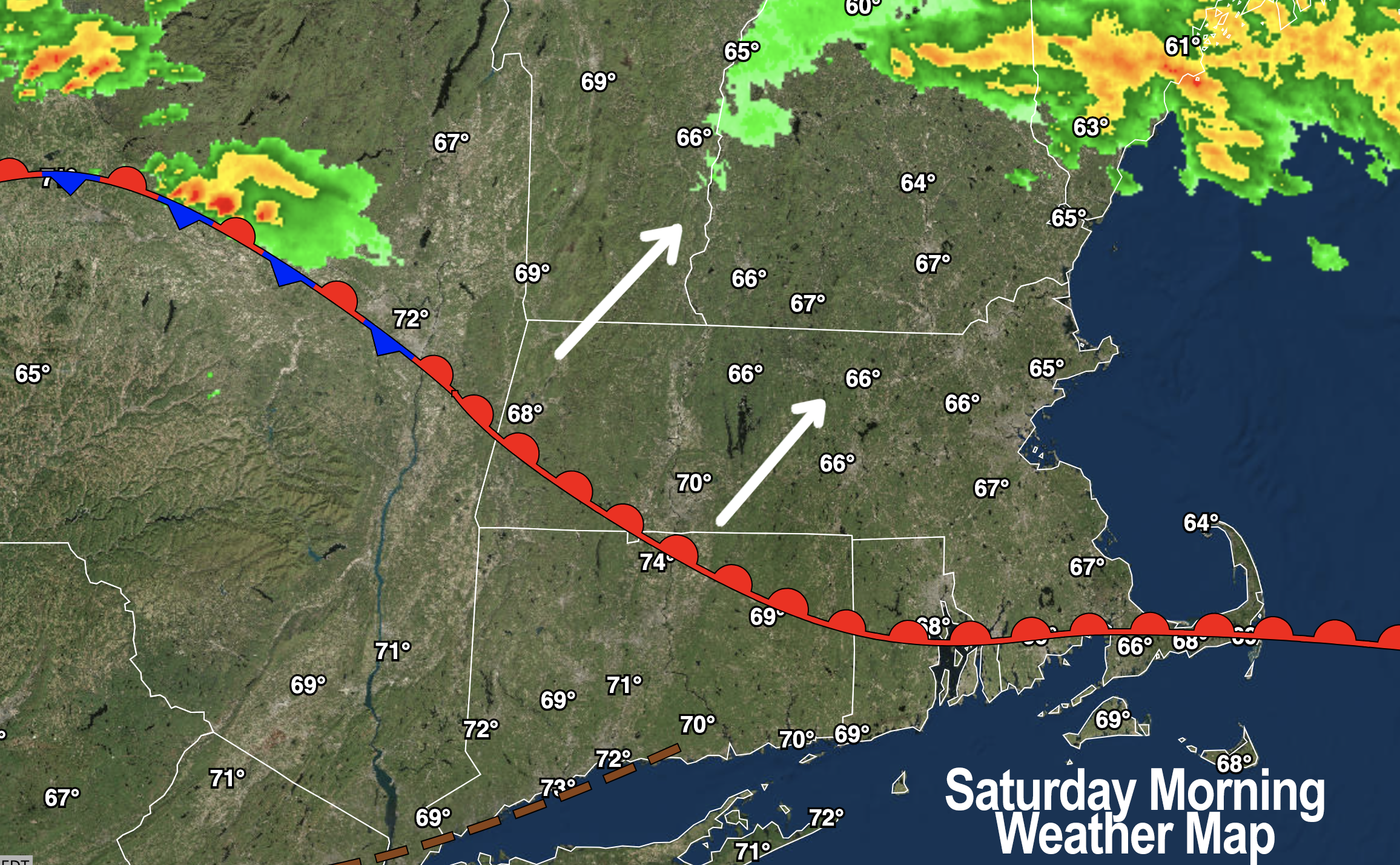
As for our weather, we continue to deal with the remnants of our giant upper heat wave ridge which shoved that hot and humid air mass deeply into the northeast U.S.
EDUCATION
Absent a strong cold front and a storm to traverse east through southern Canada to help drag and scrape all of this muck out to sea, we now see our humid air mass interacting with zonal (i.e. west to east) flow around the top (i.e. northern part) of the ridge to our south, which fuels the development of showers, downpours and thunderstorms each day.
This is amplified by waves of energy that ripple through the region, and also was amplified yesterday and will be amplified today by a fairly stationary frontal boundary in our region which helps to make air come together (a/k/a “convergence”), rise, and produce heavy rainfall in these types of air masses.
What does it all mean, Dave?
FORECAST
Well, it means that with highs in the 80s to near 90º today (and upper 80s to low 90s tomorrow) along with dewpoints in the 70s and lows only 65-70º each night, we’ll have more showers, downpours and thunderstorms to deal with this weekend, culminating in a period of showers Monday morning as the cold front comes through at a favorable time to NOT produce severe weather, like cold fronts are known to produce.
Instead, our strong/severe weather potential will be caused by the pre-frontal warm sector we’ll inhabit all weekend long (especially tomorrow on Sunday).
This frontal boundary slowly lifts northeast today, and lifts northeast and away much faster tomorrow, and given that we’ll have a few waves tracking west to east during this time, we’ll have 3 periods to watch for strong weather.
Before I try and detail these, know that an isolated shower or thunderstorm could pop at any time from late morning onward.
POTENTIAL STRONG WEATHER ROUND 1
–Uncertainty remains around position of front this afternoon
–The front will focus showers and thunderstorms along it as an afternoon wave dives east-southeast through the region
–Strong to severe thunderstorms are possible, with any hazard including localized damaging straight line wind, hail, flooding, and even a weak spinup
–Timeframe is 2-6pm, roughly
–Before 2pm looks fairly dry (but humid) for most of us, save for an isolated shower/storm, and we should see some dry periods tonight before round 2
POTENTIAL STRONG WEATHER ROUND 2
–There is a signal for another round of heavy downpours with potential for a couple of embedded non-severe thunderstorms to work west to east through the region overnight
–This rain could arrive into the Berkshires by 11pm or toward midnight and work east through the region during the pre-dawn hours
–Scattered showers may remain into Sunday morning, with clearing by mid to late morning
POTENTIAL STRONG WEATHER ROUND 3
–This is potentially the strongest period of weather, arriving mid to late Sunday afternoon and into the evening
–The warm front will be far away, and we’ll be firmly in a pre-frontal trough with some atmospheric spin moving through western New England
–A period of showers, downpours and thunderstorms are expected
–A couple of supercell thunderstorms are possible, and we can’t rule out a tornado or two in the WMass region into SVT and SWNH tomorrow later afternoon
By Sunday night into Monday morning our cold front will be sweeping the region with some night time showers.
Highs on Monday will be cooler and mostly cloudy with highs in the 70s as showers move through, leading to a partly sunny later afternoon, with lows in the upper 50s.
Tuesday and Wednesday look nice, drier, and sunny wiith highs upper 70s to mid 80s.
Another cold front brings more showers and storms Thursday, followed by a drier Friday and Saturday, with another cold front by Sunday.
Hey, at least we’re getting west to east flow and shots of drier air in the coming Monday to Monday period, something to look forwrad to after this tough weather stretch we will have endured!
Have a great day, and I will update later!
SOPHISTICATED WEATHER
HAIKU OF THE DAY:
Severe weather sucks
Thunderstorms are fun…sometimes
Other times? BIG BOOOO!
Have a great day!
“Follow your bliss and the universe will open doors for you where there were only walls.”
― Joseph Campbell