
~~~~~~~~~~~~~~~~~~~~~~
TABLE OF CONTENTS
* Daily Celestials (Sun/Moon Data)
* Sponsor Note
* Join My Newsletter (& get my Top12WMassStorms ebook!)
* Morning Discussion
* TIP: Scroll below for sections, or read all
~~~~~~~~~~~~~~~~~~~~~~
YOUR DAILY CELESTIALS
~~~~~~~~~~~~~~~~~~~~~~
STAR:
–OUR STAR ROSE AT: 5:14am this morning
–OUR STAR SETS AT: 8:29pm this evening
–TOTAL DAYLIGHT TIME: 15 hours and 15 minutes
*Peak Light and Summer Solstice at 4:50pm*
MOON:
–OUR MOON RISES AT: 7:45pm this afternoon
–MOON RISE DIRECTION: Southeast
–OUR MOON SETS AT: 4:17am tomorrow morning
–MOON SET DIRECTION: Southwest
–MOON PHASE: Waxing Gibbous (97.0%)
~~~~~~~~~~~~~~~~~~~~~~
A NOTE FROM OUR SPONSOR
~~~~~~~~~~~~~~~~~~~~~~
Dave Hayes The Weather Nut is Sponsored by Individual Community Members, Patrons, and Tandem Bagel Company… No matter the weather, Tandem Bagel is always there for you at several valley locations to make your mornings brighter! With *New Pizza Bagels(!)*, along with bagels baked fresh daily (including Gluten-Free options), house-whipped cream cheese, coffee, and tons of lunch options, Tandem is the perfect quick stop for lunch, breakfast, or a coffee and bagel to go.
You can either A) visit them in Easthampton, Northampton, Hadley, Florence, and/or West Springfield, B) hire them to cater your next event, or C) use their super-streamlined online ordering tool by visiting their website and clicking the “Catering” or “Order Online” links.
~~~~~~~~~~~~~~~~~~~~~~
GET DAVE’S TOP 12 MOST POTENT STORMS
IN WMASS HISTORY (Plus 3 honorable mentions)
Grab my detailed (and free) 70-page local storm book filled with storm histories, personal stories, and impacts/facts when you sign up for my free weekly newsletter called “The Nutletter” by clicking this link to my secure website.
~~~~~~~~~~~~~~~~~~~~~~
YOUR MORNING DISCUSSION
~~~~~~~~~~~~~~~~~~~~~~
Good morning folks, thanks for all of the reports yesterday on those isolated strong to severe thunderstorms that eventually coalesced into twin towering cells both 55000 feet tall that produced “overshooting tops” which is when updrafts are so strong that they push through the Tropopause and into the lower parts of the Stratosphere!
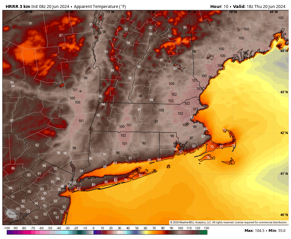
We have the same amount of “thunderstorm fuel” available today, and even more so as temps are going to peak into the mid to upper 90s for highs and dewpoints in the upper 60s to mid 70s so heat indices are expected to reach the 100-105º range.
As such Heat Advisories have been hoisted region-wide, and we have Air Quality Alerts from the MA and CT DEP offices for central/eastern Hampshire and Hampden Counties into southern CMass and Hartford County CT.
All this to say, take it easy out there, stay hydrated, find a way to cool down, and if you have respiratory issues or other heat/humidity sensitivities just stay our of the weather if you are able to do so, otherwise keep hydrated and take breaks if working outside today.
We’ll start off mostly sunny, but with our upper riidge starting to flatten out and some shortwaves “riding the ridge” from west to east in its northern extent, we will see more clusters of showers, downpours and thunderstorms form this afternoon.
We continue to have an increased chance of strong to severe thunderstorms today capable of areas of wind damage like we saw yesterday, most notably in Williamsburg and a few other areas across the region with power back on for most, except about 1000 households in Worcester County as of this writing.
Areas of flooding are also possible given potential for backbuilding of storms and high moisture content in the air.
Storms likely hold off until later this afternoon, but once we get to about 2-4pm, we could see a shower or storm at any point going forward.
Lows will dip into the upper 60s to low 70s continued very humid as any showers and storms wind down over night. Patchy fog is possible late.
For Friday, we’re watching a cold front press southwest into parts of our region, but exactly how far southwest it makes it will determine who sees their heat wave break with cooler highs in the 80s vs. low 90s, which likely sets up in parts of northern CT and perhaps even southernmost Berkshire County near Great Barrington in the Housatonic River Valley.
This front will help to focus more showers and thunderstorms as additional waves of energy ride through along it and around it, with a better chance of severe storms along and south of the Pike, with more of a heavier rain threat north of the Pike, where clusters of showers and storms do form.
Lows will sit in the 60s Friday night and it will be quite humid with scattered showers or a thunderstorm possible.
On Saturday, we will be watching a parent surface low center over the Great Lakes start to track east-northeast toward Quebec, and as such, we will likely (at some point) see our old backdoor cold front return as a warm front later Saturday afternoon and evening, which means the first part of Saturday is likely drier (though still very humid), with showers and somoe thunderstorms pushing back into the region later in the afternoon and evening as the front passes through.
Highs Saturday reach the upper 70s to mid 80s with lows in the 60s.
Later Saturday night into much of Sunday we will be back into a soupier, warmer air mass behind the front with highs in the mid 80s to low 90s and a dry start to the day, which hopefully lasts well into the afternoon.
However, a cold front attached to that Great Lakes surface low will track drag a cold front into the region by Sunday evening and overnight, bringing more showers and thunderstorms through into Monday before clearing the region to the east.
Lows Sunday night will be in the mid to upper 60s with highs in the low to mid 80s on Monday as partly sunny skies develop in the afternoon.
Monday night will present the first good sleeping night in days since this heat wave began, with lows in the upper 50s, with a lovely, sunny and dry day for Tuesday with highs in the low to mid 80s.
Wednesday becomes warmer and more humid with highs in the mid 80s to low 90s as high pressure passes to our south again.
Another cold front comes through with showers/storms later Wednesday into Wednesday night, which will bring more dry air moving in for late week, so that is something to look forward to!
Have a great day, and check back with me later as I will be monitoring and tracking severe weather potential all day and evening, and updating when needed.
>>> BE KIND <<<
“Hello babies. Welcome to Earth. It’s hot in the summer and cold in the winter. It’s round and wet and crowded. On the outside, babies, you’ve got a hundred years here. There’s only one rule that I know of, babies: Goddamn it, you’ve got to be kind.”
–Kurt Vonnegut