~~~~~~~~~~~~~~~~~~~~~~
TABLE OF CONTENTS
* Daily Celestials (Sun/Moon Data)
* Sponsor Note
* Join My Newsletter (Free 70 page ebook)
* Morning Discussion
* TIP: Scroll below for sections, or read all
~~~~~~~~~~~~~~~~~~~~~~
YOUR DAILY CELESTIALS
~~~~~~~~~~~~~~~~~~~~~~
STAR:
–OUR STAR ROSE AT: 5:14am this morning
–OUR STAR SETS AT: 8:29pm this evening
–TOTAL DAYLIGHT TIME: 15 hours and 15 minutes
*Peak Light*
MOON:
–OUR MOON RISES AT: 5:26pm this afternoon
–MOON RISE DIRECTION: East-Southeast
–OUR MOON SETS AT: 2:57am tomorrow morning
–MOON SET DIRECTION: West-Southwest
–MOON PHASE: Waxing Gibbous (86.4%)
~~~~~~~~~~~~~~~~~~~~~~
A NOTE FROM OUR SPONSOR
~~~~~~~~~~~~~~~~~~~~~~
Dave Hayes The Weather Nut is Sponsored by Individual Community Members, Patrons, and Tandem Bagel Company… No matter the weather, Tandem Bagel is always there for you at several valley locations to make your mornings brighter! With *New Pizza Bagels(!)*, along with bagels baked fresh daily (including Gluten-Free options), house-whipped cream cheese, coffee, and tons of lunch options, Tandem is the perfect quick stop for lunch, breakfast, or a coffee and bagel to go.
You can either A) visit them in Easthampton, Northampton, Hadley, Florence, and/or West Springfield, B) hire them to cater your next event, or C) use their super-streamlined online ordering tool by visiting their website and clicking the “Catering” or “Order Online” links.
~~~~~~~~~~~~~~~~~~~~~~
GET DAVE’S TOP 12 MOST POTENT STORMS
IN WMASS HISTORY (Plus 3 honorable mentions)
Grab my detailed (and free) 70-page local storm book filled with storm histories, personal stories, and impacts/facts when you sign up for my free weekly newsletter called “The Nutletter” by clicking this link to my secure website.
~~~~~~~~~~~~~~~~~~~~~~
YOUR MORNING DISCUSSION
~~~~~~~~~~~~~~~~~~~~~~
Good morning folks, our first heat wave of the season is arriving this week, starting today.
We have a giant high pressure dome to our south, and a massive upper ridge over the eastern U.S.
These will combine to produce strong southwest flow into the region, pumping heat and humidity, and allowing high temps to rise into the low to mid 90s today and tomorrow.
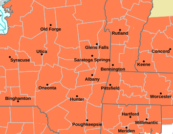
With dewpoints in the mid 60s to low 70s, heat indices will rise into the upper 90s, hence the hoisting of the region-wide Heat Advisories by the NWS, as well a few Air Quality Alerts by the MA DEP in the southern valley east into southern CMass.
High temps will reach the upper 80s to mid 90s today and tomorrow, and the mid to upper 90s by Thursday when our heat wave peaks poetically as we drift through the Summer Solstice on Thursday at 4:50pm.
Expect mostly sunny skies all three days, but skies will be hazy at times, and we could see a couple of isolated showers or thunderstorms each afternoon, more so today and/or tomorrow.
Any storms would likely be kicked off by what is called differential heating combined with the presence of mountains (mostly west of the I-91 corridor) which could force a few high terrain boomers to form. They likely would be sub-severe with low wind shear present.
Lows each night through Thursday night will provide little relief, dropping only into the mid 60s to low 70s.
By Friday, uncertainty looms as the upper ridge instead of being oriented southwest to northeast “flattens out” and becomes more west to east, allowing some energy to track towards our region, along with a cold front that will be sagging south from northern New England into southern New England.
How far south does it get and when?
That is still to be determined and could cause wide ranges in high temps across my coverage area of the greater WMass region, meaning we could see mid 80s to low 90s in the southern valley, and upper 70s to mid 80s in northern MA up into SVT/SWNH.
Also, a higher chance for more numerous showers and thunderstorms exists for Friday afternoon and evening, but I will have to update as we get closer.
The bottom line is that the weekend should produce a break in the heat wave as that front eventually makes it south of us through Saturday night, but humidity will persist, and so will the chance for some scattered showers and thunderstorms.
Highs at this point should be in the 80s over the weekend, and then we’ll see that frontal boundary come north overnight, and hopefully set up Sunday as a mostly dry but mostly cloudy day with a chance for stronger showers and storms later at night as a cold front moves into the region into Monday morning.
Highs at this point should crest into the 80s all weekend and into early next week as some drier air tries to work into the region.
Have a great day!
>>> BE KIND <<<
“Hello babies. Welcome to Earth. It’s hot in the summer and cold in the winter. It’s round and wet and crowded. On the outside, babies, you’ve got a hundred years here. There’s only one rule that I know of, babies: Goddamn it, you’ve got to be kind.”
–Kurt Vonnegut
