
~~~~~~~~~~~~~~~~~~~~~~
TABLE OF CONTENTS
* Daily Celestials (Sun/Moon Data)
* Sponsor Section
* Morning Discussion
* TIP: Scroll to your section, or read all
~~~~~~~~~~~~~~~~~~~~~~
YOUR DAILY CELESTIALS
~~~~~~~~~~~~~~~~~~~~~~
STAR:
–OUR STAR ROSE AT: 5:13am this morning
–OUR STAR WILL SET AT: 8:28pm this evening
–TOTAL DAYLIGHT TIME: 15 hours and 15 minutes
***Peak Light!***
MOON:
–OUR MOON WILL RISE AT: 2:13pm this afternoon
–MOON RISE DIRECTION: East
–OUR MOON WILL SET AT: 1:47am tomorrow morning
–MOON SET DIRECTION: West
–MOON PHASE: Waxing Gibbous Crescent (62.2%)
~~~~~~~~~~~~~~~~~~~~~~
>>> A NOTE FROM OUR WEEKEND SPONSOR <<<
Dave Hayes The Weather Nut is Sponsored by Individual Community Members, Patrons, and Gerard, Ghazey & Bates, P.C. GGBPC is a Northampton-based law firm regarded as the voice of pragmatic and well-reasoned estate planning, elder law and tax guidance in Western Massachusetts. The firm specializes in estate planning law, and expertly handles other matters such as Elder Law, Tax Law, as well as Real Estate purchase, sales, and refinance transactions. Contact GGBPC today to see how they can help!
~~~~~~~~~~~~~~~~~~~~~~
YOUR MORNING DISCUSSION
~~~~~~~~~~~~~~~~~~~~~~
Good morning folks, thanks very much for all of the reports and interactions yesterday, thankfully overall the morning showers lines tamped down the instability enough to make yesterday more of a Level 1 out of 5 severe storm risk day, than the level 2 forecasts by the SPC.
We had one severe thunderstorm warning along with a few strong storms that dropped hail, caused some wind damage in Hampden County, and also caused a couple of very serious street flooding events in Holyoke and further south in West Springfield. That light show last night as something, too!
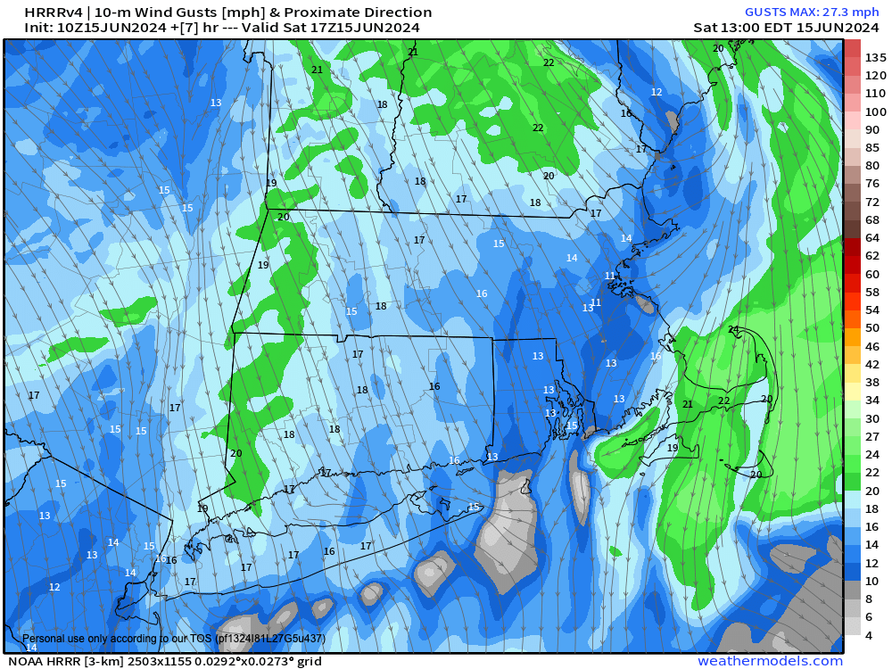
As for our weather going forward, we just have an abundance of sunshine on the way that will start with dry air advecting in froom the north thanks to high pressure to our northwest.
This will cause northerly gusts to blow 15-25mph at times today under sunny skies with highs in the 70s, and much lower humidity with dewpoints in the 40s and 50s.
In fact, for tonight, low air temps should drop to the 40-45º range, which is VERY cool for mid June, though not a record with a number of instances in the mid to upper 30s in our past.
Tomorrow, Father’s Day, is a repeat of today, though with a few high clouds possible and highs firmly up into the 75-80º range, with lows in the 50s.
By Monday, we reach our transition day as the cooling/drying high pressure system to our northwest slides southeast to a position south of New England by next week, developing to a huge and potent Bermuda High while a massive and highly anomalous upper ridge develops in the northeast U.S.
This setup will initiate southwest flow and cause temps to come up into the 80s on Monday under sunny skies with dewpoints cresting 60º as humidity builds.
Lows will be in the low 60s.
Once we hit Tuesday, the heat wave begins.
Highs will soar well into the 90s, with some upper 90s possible in the Pioneer Valley.
Air Quality Alerts may end up being hoisted by the applicable state Departments of Environmental Protection during the Tuesday through Saturday timeframe.
Heat indices will likely rise into the 95-105º range, and consequently NWS-issued Heat Advisories and/or Excessive Heat Warnings could be hoisted during this upcoming heat wave.
Again, I can’t emphasize enough that high temperatures from Tuesday through Saturday will likely be in the upper 80s in the high peaks of SVT, but otherwise well into the 90s every day with dewpoints in the 60s and 70s with high humidity at times.
Low air temps will only fall into the mid to upper 60s into the 70s with little night time relief.
For folks who are heat sensitive, or who have respiratory issues, or infirmities negatively affected by heat and humidity like this (as well as outdoor workers), it will not be a fun stretch to stay the least.
As such folks will need to prepare now to make sure they have adequate cooling and hydrating resources and plans in place whenever possible, and to also protect from sun, heat and humidity.
I will be posting numerous National Weather Service heat infographics in the coming days with tips to consider as we get ready to deal with this upcoming heat wave.
This hot air mass will be a stable one, however, that being warm from surface to sky, so no precipitation is expected at this time.
By end of week into the weekend, however, we may see that change with some showers and thunderstorms possible by late week into the weekend, but that’s a long way off and I will update as we get closer.
For now, I can’t encourage you enough to get out and enjoy the next three days, especially this weekend, what a gift!
Lastly, I am not reporting tomorrow, because of our stable, lovely weather expected, and so I can get a little sleep.
HAIKU OF THE DAY:
Hot Humid Heat Looms
Hydration, Shade, and Cooling
These Are Your Mantras
Have a great day!
“Follow your bliss and the universe will open doors for you where there were only walls.”
― Joseph Campbell