
~~~~~~~~~~~~~~~~~~~~~~
TABLE OF CONTENTS
* Daily Celestials (Sun/Moon Data)
* Weekly Weather Nutshell
* Morning Discussion
* TIP: Scroll below for sections, or read all
~~~~~~~~~~~~~~~~~~~~~~
YOUR DAILY CELESTIALS
~~~~~~~~~~~~~~~~~~~~~~
STAR:
–OUR STAR ROSE AT: 5:15am this morning
–OUR STAR SETS AT: 8:21pm this evening
–TOTAL DAYLIGHT TIME: 15 hours and 6 minutes
MOON:
–OUR MOON SETS AT: 5:25pm this afternoon
–MOON SET DIRECTION: West-Northwest
–OUR MOON RISES AT: 3:33am tomorrow morning
–MOON RISE DIRECTION: East-Northeast
–MOON PHASE: Waning Crescent (12.2%)
~~~~~~~~~~~~~~~~~~~~~~
A NOTE FROM OUR SPONSOR
~~~~~~~~~~~~~~~~~~~~~~
Dave Hayes The Weather Nut is Sponsored by Individual Community Members, Patrons, and Tandem Bagel Company… No matter the weather, Tandem Bagel is always there for you at several valley locations to make your mornings brighter! With *New Pizza Bagels(!)*, along with bagels baked fresh daily (including Gluten-Free options), house-whipped cream cheese, coffee, and tons of lunch options, Tandem is the perfect quick stop for lunch, breakfast, or a coffee and bagel to go.
You can either A) visit them in Easthampton, Northampton, Hadley, Florence, and/or West Springfield, B) hire them to cater your next event, or C) use their super-streamlined online ordering tool by visiting their website and clicking the “Catering” or “Order Online” links.
~~~~~~~~~~~~~~~~~~~~~~
YOUR WEEKLY WEATHER NUTSHELL
~~~~~~~~~~~~~~~~~~~~~~
–Mostly sunny today after some morning clouds, highs upper 70s to mid 80s, maybe a few cloudier periods well east of I-91
–Lows mid 50s to low 60s
–Partly to mostly sunny tomorrow, highs either side of 80º
–An isolated shower or thunderstorm is possible in the afternoon
–Lows 55-60º
–Wednesday looks partly sunny with a trough approaching from the west, kicking our upper ridge that brought the sun and warmth out to sea
–Highs once again in the upper 70s to mid 80s with clouds building from the west late
–A few showers moving in Wednesday evening and night
–Thursday looks wet, showery with downpours and thunderstorms at times, but nothing severe, highs in the 70s, lows in the 50s
–Friday through Sunday feature mixed sky days, with scattered instability showers or thunderstorms in the afternoon possible, with details to be nailed down as we get closer
–Overall we are cooler with highs in the 70s and lows in the 50s
~~~~~~~~~~~~~~~~~~~~~~
YOUR MORNING DISCUSSION
~~~~~~~~~~~~~~~~~~~~~~
Good morning everybody, it’s a mild start today with many folks already cresting 60º, and this will help push highs up into the low to mid 80s for many of us, perhaps upper 70s in SVT.
We’ve got another three days of mostly dry weather along with mostly sunny skies expected, with the exception of more partly sunny skies on average as you head east today.
This is primarily due to an incoming back door cold front that comes in off the ocean and fizzles over EMass or perhaps parts of CMass down into far northeast CT.
Lows tonight will dip into the mid to upper 50s under partly cloudy skies.
For Tuesday, we’ll reach the upper 70s to low 80s for highs under mostly sunny skies as high pressure to our south continues to dominate our sensible weather.
However, we will also have a chance at an isolated shower or thunderstorm later in the afternoon as cooler air passes over aloft and steepens the lower lapse rates.
Lows drop again into the 55-60º range.
By Wednesday, we’re going to be seeing an upper level trough swing into the Great Lakes and eventually the northeast U.S. into Quebec Province by Thursday and through the weekend, which will cool us down and destabilize the atmosphere to allow showers and thunderstorms at times.
Having said that, Wednesday still looks like a very nice day with one final bout of warmth and highs in the upper 70s to low 80s or so, under partly sunny skies with clouds building in from the west later in the day. A few showers are possible late.
The trough and an associated surface low approach at night, spreading clouds and showers into the region with lows in the low 60s with thunder possible.
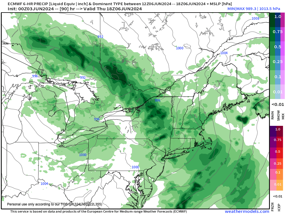
By Thursday (chart attached), we’re fully into a showery day with downpours at times, and some embedded thunderstorms as a wave swings through the region. Highs will be cooler, only in the 70s, and showers should continue into the evening with lows in the 50s.
The Friday through Sunday period looks to be dominated by this upper low more or less parked between eastern Ontario and western Quebec Provinces in Canada.
When this happens, these larger atmospheric gyres send shortwaves around their southern and southeast flanks into New England at times, which can be hard to time at this range.
For now, we can reasonably expect periods of showers or t-storms mixed with partly sunny skies, and cooler highs under that trough in the 70s with lows in the 50s.
Sunday may end up being brighter than Saturday, but for now we may stay under the influence of that trough into early next week, as it could prove hard to dislodge.
Haiku of the Day:
–Stillness begets calm
–Air-suspension firmament
–Hang in the balance
Have a great day!
>>> BE KIND <<<
“Hello babies. Welcome to Earth. It’s hot in the summer and cold in the winter. It’s round and wet and crowded. On the outside, babies, you’ve got a hundred years here. There’s only one rule that I know of, babies: Goddamn it, you’ve got to be kind.”
–Kurt Vonnegut