~~~~~~~~~~~~~~~~~~~~~~
TABLE OF CONTENTS
* Daily Celestials (Sun/Moon Data)
* Weekly Weather Nutshell
* Morning Discussion
* TIP: Scroll below for sections, or read all
~~~~~~~~~~~~~~~~~~~~~~
YOUR DAILY CELESTIALS
~~~~~~~~~~~~~~~~~~~~~~
STAR:
–OUR STAR ROSE AT: 5:22am this morning
–OUR STAR SETS AT: 8:12pm this evening
–TOTAL DAYLIGHT TIME: 14 hours and 50 minutes
MOON:
–OUR MOON RISES AT: 8:52pm this evening
–MOON RISE DIRECTION: Southeast
–OUR MOON SETS AT: 5:37am tomorrow morning
–MOON SET DIRECTION: Southwest
–MOON PHASE: Full Flower Moon (99.9%)
~~~~~~~~~~~~~~~~~~~~~~
A NOTE FROM OUR SPONSOR
~~~~~~~~~~~~~~~~~~~~~~
Dave Hayes The Weather Nut is Sponsored by Individual Community Members, Patrons, and Tandem Bagel Company… No matter the weather, Tandem Bagel is always there for you at several valley locations to make your mornings brighter! With *New Pizza Bagels(!)*, along with bagels baked fresh daily (including Gluten-Free options), house-whipped cream cheese, coffee, and tons of lunch options, Tandem is the perfect quick stop for lunch, breakfast, or a coffee and bagel to go.
You can either A) visit them in Easthampton, Northampton, Hadley, Florence, and/or West Springfield, B) hire them to cater your next event, or C) use their super-streamlined online ordering tool by visiting their website and clicking the “Catering” or “Order Online” links.
~~~~~~~~~~~~~~~~~~~~~~
YOUR WEEKLY WEATHER NUTSHELL
~~~~~~~~~~~~~~~~~~~~~~
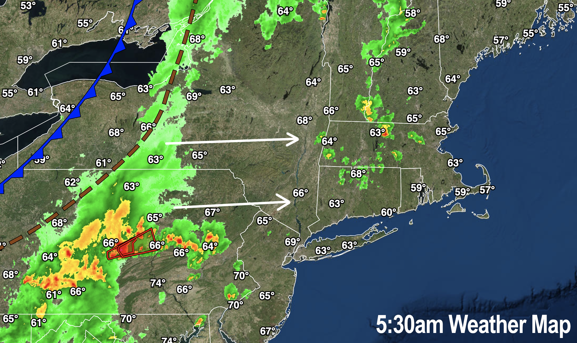
–Scattered showers, downpours, and thunderstorms are on the way by late morning into mid afternoon or so
–A few showers have already developed and the wet ground earlier, with a t-storm in far northeast CT this morning
–A cold front will move into the region later this afternoon
–Ahead of it, temps are already in the 60s with dewpoints close behind
–Highs reach the upper 70s to mid 80s with partly sunny to mostly cloudy skies developing
–Main timeframe for impacts is about 11am to 3pm or so
–Potential exists for street flooding, larger hail and isolated areas of damaging wind gusts capable of knocking out power
–Some showers or a thunderstorm is possible after 3pm, but the main brunt appears to be 11am-3pm or so for now (I will update mid-day)
–Activity sits down tonight as the front moves through with lows in the mid to upper 50s
–Friday and Saturday look mostly sunny with highs in the mid 70s to mid 80s along with lower humidity, and lows in the 50s
–Both Saturday evening and Sunday evening could finish with a few showers or a t-storm as a pair of shortwaves float nearby the region
–Sunday looks warmer with highs mostly in the low to mid 80s
–By Memorial Day Monday into the middle of next week our weather goes downhill with widespread rain possible by Monday afternoon and/or evening into the overnight
–Shower chances will continue for Tuesday and Wednesday with cooler and more seasonable temps in the low to mid 70s
~~~~~~~~~~~~~~~~~~~~~~
YOUR MORNING DISCUSSION
~~~~~~~~~~~~~~~~~~~~~~
Good morning everybody, humanity continues to be nuts, so raise those eyebrows and put on a slight smile as you think about something you like or someone you love, and proceed out and into the land where we put one foot in front of the other and do the best we can do in the situations in which we find ourselves.
And don’t forget to have a snack while you’re at it! #SnacksAreGoooooood
As far as our weather is concerned, we’ve got a busy day today with potentially impactful showers, downpours and thunderstorms already tracking east-northeast toward our region, with some early morning activity having already passed through.
This is in response to a cold front that will move the region late today.
I’m not expecting a large squall line per se, but the instability due to increased humidity, warming temps this morning, and decent enough wind shear will all combine to produce clusters of showers, downpours and thunderstorms, some of which may be strong to severe and produce larger hail, street flooding and isolated damaging wind gusts capable of causing tree damage or power outages in localized areas.
Again, the main timeframe for impact is 11am-3pm or so, with a few showers or storms possible after 3pm, with activity moving out of the region before sunset, I believe.
We calm down and dry out tonight, and then enjoy a gorgeous day of high pressure and sunshine for Friday with very warm temps (see the Weekly Weather Nutshell above for details).
Friday night is cool and clear, and then Saturday and Sunday look pretty darn nice with mostly sunny skies each day the way it looks now, and a chance for late day instability showers or thunderstorms to be scattered about as a pair of shortwaves swing by the region, separated by brief areas of high pressure during each day.
It is Monday, Memorial Day, that looks pretty wet with a strong storm system ripping into the Great Lakes region and sending periods of rainfall our way by Monday afternoon/night and again Tuesday and Wednesday with cooling temps into the 70s.
There’s a lot to refine for the later holiday weekend so check back with me, and I will update again around mid day today for our incoming severe weather potential.
Have a great day!
>>> BE KIND <<<
“Hello babies. Welcome to Earth. It’s hot in the summer and cold in the winter. It’s round and wet and crowded. On the outside, babies, you’ve got a hundred years here. There’s only one rule that I know of, babies: Goddamn it, you’ve got to be kind.”
–Kurt Vonnegut
