~~~~~~~~~~~~~~~~~~~~~~
TABLE OF CONTENTS
* Daily Celestials (Sun/Moon Data)
* Weekly Weather Nutshell
* Morning Discussion
* TIP: Scroll below for sections, or read all
~~~~~~~~~~~~~~~~~~~~~~
YOUR DAILY CELESTIALS
~~~~~~~~~~~~~~~~~~~~~~
STAR:
–OUR STAR ROSE AT: 5:24am this morning
–OUR STAR SETS AT: 8:09pm this evening
–TOTAL DAYLIGHT TIME: 14 hours and 45 minutes
MOON:
–OUR MOON RISES AT: 5:28pm this afternoon
–MOON RISE DIRECTION: East-Southeast
–OUR MOON SETS AT: 4:04am tomorrow morning
–MOON SET DIRECTION: West-Southwest
–MOON PHASE: Waxing Gibbous (90.5%)
~~~~~~~~~~~~~~~~~~~~~~
A NOTE FROM OUR SPONSOR
~~~~~~~~~~~~~~~~~~~~~~
Dave Hayes The Weather Nut is Sponsored by Individual Community Members, Patrons, and Tandem Bagel Company… No matter the weather, Tandem Bagel is always there for you at several valley locations to make your mornings brighter! With *New Pizza Bagels(!)*, along with bagels baked fresh daily (including Gluten-Free options), house-whipped cream cheese, coffee, and tons of lunch options, Tandem is the perfect quick stop for lunch, breakfast, or a coffee and bagel to go.
You can either A) visit them in Easthampton, Northampton, Hadley, Florence, and/or West Springfield, B) hire them to cater your next event, or C) use their super-streamlined online ordering tool by visiting their website and clicking the “Catering” or “Order Online” links.
~~~~~~~~~~~~~~~~~~~~~~
YOUR WEEKLY WEATHER NUTSHELL
~~~~~~~~~~~~~~~~~~~~~~
–Good morning folks, low clouds and some patchy fog has setup in the region this morning
–With drying aloft, breaks in the low cloud deck will eventually work down to the surface as the sun climbs and mixes the atmosphere
–High pressure east-northeast of us sinks south into tomorrow and mid week, allowing southerly flow to develop, including more sunshine and warmer temps
–Dry weather persists into Thursday
–Highs today should reach the mid 70s to low 80s
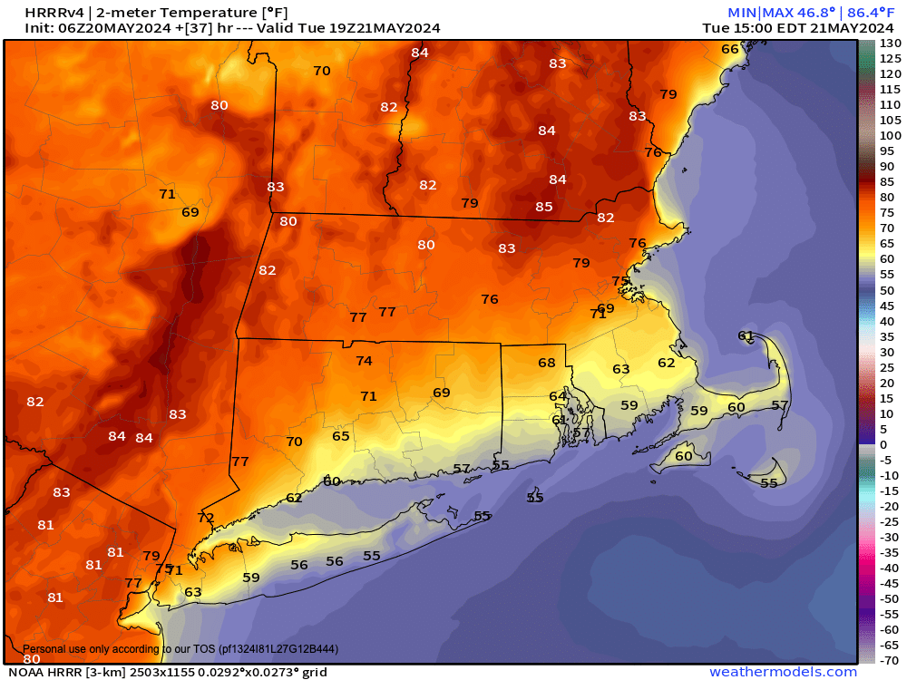
–Highs Tuesday should reach the upper 70s to mid 80s
–Highs on Wednesday should climb well into the 80s, with a few low 90s possible, which’ll be the warmest day of 2024 to date!
–Lows dip into the mid 50s tonight with patchy fog possible
–Lows bottom out in the upper 50s to mid 60s Tuesday and Wednesday nights
–By Thursday, clouds increase as a cold front works southeast into the region
–If this front is delayed and holds off until afternoon to pass through, highs could climb into the 80s
–This could also allow for stronger showers and thunderstorms to develop, so stay tuned for updates
–By Friday and Saturday (behind the front) we’ll cool down into the low to mid 70s for highs under mostly sunny skies with lows in the low 50s
–Some showers are possible late next Sunday into Memorial Day itself with seasonable temps, but I will update as we closer
~~~~~~~~~~~~~~~~~~~~~~
YOUR MORNING DISCUSSION
~~~~~~~~~~~~~~~~~~~~~~
Good morning everybody, despite nearby high pressure and a building upper ridge over our region, high pressure to our east-northeast has been stubborn to drop south to get us into the persistently southerly flow to break the onshore air movement so we can bust out into full sunshine more readily.
This is going to change over the next day or two, and as a result sunshine should be increasing through the next 3 days, with warming temps as a result.
I do think that despite this morning’s low clouds with some patchy fog that we’ll get into at least a partly sunny day with highs either side of 80º by afternoon.
Lows will dip into the 50s and we could see some more patchy fog tonight, along with a sleepy start in terms of sun tomorrow morning, but with high pressure developing to our south, we should more readily get into the sunshine with highs soaring into the low to mid 80s for many of us by tomorrow afternoon.
Wednesday will feature peak heat with highs in the mid 80s to low 90s as full sunshine and southwest flow develops with high pressure firmly south of us.
However, Thursday a cold front will be slicing southeast and bringing some decent wind shear with it. If it arrives after noon, this could provide extra fuel in terms of warm surface temps into the low 80s or so to help develop scattered strong thunderstorms and some heavy rain showers, lasting into the evening.
This front keeps trucking east, and should pull in a drier, cooler and seasonable air mass with highs in the 70s and lows in the 50s under increasing sunshine, which should last into at least Saturday.
Sunday may be a transition day with warmer temps, but a chance for a few showers that may last into Memorial Day itself.
There are some signals for a wetter week next week, but we’ll stay focused on the mostly dry weather we have coming through Saturday, save for a potentially stormy Thursday.
Have a great day!
>>> BE KIND <<<
“Hello babies. Welcome to Earth. It’s hot in the summer and cold in the winter. It’s round and wet and crowded. On the outside, babies, you’ve got a hundred years here. There’s only one rule that I know of, babies: Goddamn it, you’ve got to be kind.”
–Kurt Vonnegut
