~~~~~~~~~~~~~~~~~~~~~~
TABLE OF CONTENTS
* Daily Celestials (Sun/Moon Data)
* Weekly Weather Nutshell
* Morning Discussion
* TIP: Scroll below for sections, or read all
~~~~~~~~~~~~~~~~~~~~~~
YOUR DAILY CELESTIALS
~~~~~~~~~~~~~~~~~~~~~~
STAR:
–OUR STAR ROSE AT: 5:26am this morning
–OUR STAR WILL SET AT: 8:07pm this evening
–TOTAL DAYLIGHT TIME: 14 hours and 41 minutes
MOON:
–OUR MOON WILL RISE AT: 3:24pm this morning
–MOON RISE DIRECTION: East
–OUR MOON WILL SET AT: 3:25am tomorrow morning
–MOON SET DIRECTION: West
–MOON PHASE: Waxing Gibbous (77.1%)
~~~~~~~~~~~~~~~~~~~~~~
>>> A NOTE FROM OUR SPONSOR <<<
Dave Hayes The Weather Nut is Sponsored by Individual Community Members, Patrons, and Gerard, Ghazey & Bates, P.C. GGBPC is a Northampton-based law firm regarded as the voice of pragmatic and well-reasoned estate planning, elder law and tax guidance in Western Massachusetts. The firm specializes in estate planning law, and expertly handles other matters such as Elder Law, Tax Law, as well as Real Estate purchase, sales, and refinance transactions. Contact GGBPC today to see how they can help!
~~~~~~~~~~~~~~~~~~~~~~
YOUR WEEKLY WEATHER NUTSHELL
~~~~~~~~~~~~~~~~~~~~~~
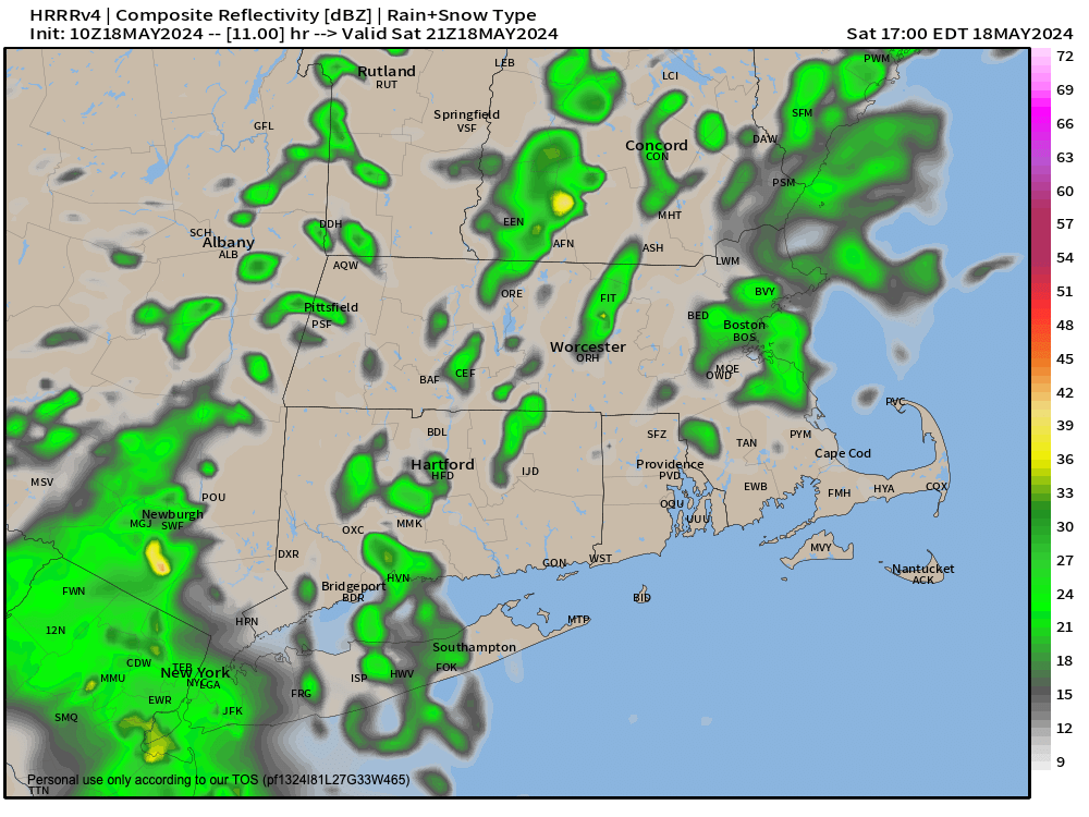
–Mostly cloudy today, best chance of showers is east of I-91 into CMass and northeast CT with onshore flow component
–The other component of a shortwave passing east through northern New England brings other rain showers at times
–However, this is not a washout, and some areas remain dry and just mostly cloudy, but best chance for a wet ground is east
–Highs upper 50s to mid 60s, and lows low 50s with any showers ending, and some patchy fog possible
–Sunday is a bit of a slower transition to sunshine-y conditions as pesky ocean low is slow to depart
–We’ll call it partly sunny, with increasing sunshine in the valley westward, highs reach the upper 60s to low 70s with lows again near 50º
–Monday to Wednesday looks super sunny and WARM, with highs either side of 80º Monday and the low to mid 80s Tuesday and Wednesday with lows in the 50s
–Clouds increase Wednesday night with a cold front passing through Thursday with showers and perhaps a thunderstorm with highs in the 70s to low 80s
–Sunshine should return by late week with highs in the 70s
~~~~~~~~~~~~~~~~~~~~~~
YOUR MORNING DISCUSSION
~~~~~~~~~~~~~~~~~~~~~~
Good morning folks, we’re dealing with the confluence of two systems that in combination shall sock us in the clouds along with producing periods of showers for today and this evening.
We’ve got that pesky ocean low that brought a soaking rain on Thursday for many bobbing north again.
Given that it is south-southeast of us, with counterclockwise circulation, it is driving onshore flow off of the ocean from east to west, slinging moisture into southern New England as a whole, of which the greater WMass region is a part.
This flow in combo with a mid-level shortwave tracking east from New York through northern New England brings the clouds and scattered showers.
The “shower-producer” component seems to be more the onshore flow, and so areas like eastern CT and CMass should see showers developing this morning, and by afternoon scattered showers will be possible anywhere in the greater WMass region, but more so east of I-91.
Highs are cool, only in the upper 50s to mid 60s, and a few breaks of sun in WMass are possible, with lows near 50º.
Sunday is a transition day as high pressure builds in from the southwest, the shortwave kicks east, and the ocean low gets overwhelmed by drier air pushing east and enveloping it like a meteorological macrophage, muting its impact, and casting it seaward to bother the fish.
Partly sunny skies develop with highs in the 70s.
Monday through Wednesday is a taste of early Summah with highs ranging from the mid 70s to mid 80s and lows in the 50s under sunny and mostly clear skies.
Thursday should see a cold front running through the region with some showers or a thunderstorm with similar high temps, followed by a sunnier Friday with highs in the 70s, which may extend into Saturday.
By next Sunday, we watch a storm that may track into our region, or stay south, so stay tuned! Have a great day!
P.S. I am taking tomorrow off, I need to get some sleep, which has been eluding me lately.
>>> BE KIND <<<
“Hello babies. Welcome to Earth. It’s hot in the summer and cold in the winter. It’s round and wet and crowded. On the outside, babies, you’ve got a hundred years here. There’s only one rule that I know of, babies: Goddamn it, you’ve got to be kind.”
–Kurt Vonnegut
