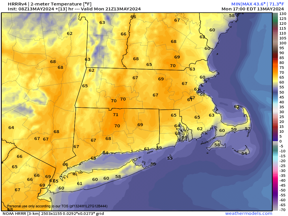
[7:05AM MON 5/13/24] CHILLY START WITH PATCHY DENSE FOG IN THE BERKSHIRES BURNS OFF FOLLOWED BY A MILDER FINISH TODAY WITH SUNSHINE EARLY AND A FEW SCATTERED SHOWERS LATE IN THE DAY AS A WARM FRONT MOVES TOWARD US THIS EVENING… WARMER TUESDAY WITH SCATTERED SHOWERS AND A COUPLE THUNDERSTORMS BY AFTERNOON AND EVENING, SOUTHERLY GUSTS OVER 20MPH POSSIBLE… TUESDAY NIGHT INTO WEDNESDAY LOOKS SHOWERY, ESPECIALLY SOUTH OF THE VT-NH/MA STATE LINE… SHOWERS MAY LINGER INTO THE LATE WEEK THURS-SAT PERIOD, MURKY DETAILS… SUNDAY IS NEXT WEEKEND PICK FOR NOW… MILD AND SEASONABLE THROUGHOUT…

~~~~~~~~~~~~~~~~~~~~~~
TABLE OF CONTENTS
* Daily Celestials (Sun/Moon Data)
* Weekly Weather Nutshell
* Morning Discussion
* TIP: Scroll below for sections, or read all
~~~~~~~~~~~~~~~~~~~~~~
YOUR DAILY CELESTIALS
~~~~~~~~~~~~~~~~~~~~~~
STAR:
–OUR STAR ROSE AT: 5:31am this morning
–OUR STAR SETS AT: 8:02pm this evening
–TOTAL DAYLIGHT TIME: 14 hours and 31 minutes
MOON:
–OUR MOON RISES AT: 10:07am this morning
–MOON RISE DIRECTION: Northeast
–OUR MOON SETS AT: 1:41am tomorrow morning
–MOON SET DIRECTION: Northwest
–MOON PHASE: Waxing Crescent (30.5%)
~~~~~~~~~~~~~~~~~~~~~~
A NOTE FROM OUR SPONSOR
~~~~~~~~~~~~~~~~~~~~~~
Dave Hayes The Weather Nut is Sponsored by Individual Community Members, Patrons, and Tandem Bagel Company… No matter the weather, Tandem Bagel is always there for you at several valley locations to make your mornings brighter! With *New Pizza Bagels(!)*, along with bagels baked fresh daily (including Gluten-Free options), house-whipped cream cheese, coffee, and tons of lunch options, Tandem is the perfect quick stop for lunch, breakfast, or a coffee and bagel to go.
You can either A) visit them in Easthampton, Northampton, Hadley, Florence, and/or West Springfield, B) hire them to cater your next event, or C) use their super-streamlined online ordering tool by visiting their website and clicking the “Catering” or “Order Online” links.
~~~~~~~~~~~~~~~~~~~~~~
YOUR WEEKLY WEATHER NUTSHELL
~~~~~~~~~~~~~~~~~~~~~~
–Patchy dense fog in parts of Hampshire, Berkshire, and Litchfield Counties should burn off soon as temps come up
–High pressure builds to our south, putting us into southerly flow as our upper low kicks seaward
–This warms us up to either side of 70º under mostly sunny skies for a good part of the day
–Said high pressure also slings a warm front our way from the southwest
–This will produce some increasing clouds late today, with scattered showers in spots
–Lows will dip to the low 50s with any showers exiting after midnight
–For Tuesday, we’re in the warm sector, with highs climbing into the mid to upper 70s
–Again we should start off partly to mostly sunny, but clouds will build as a wave passes to our south and pushes more clouds and showers into the region by late afternoon or evening
–Some thunderstorms or downpours are possible
–Gusty southerlies ahead of this activity could blow over 20mph at times, possibly up to 30mph
–Tuesday night looks wet with lows in the mid to upper 50s, and this wet environment continues into Wednesday with highs in the 60s
–The Wednesday night through Saturday period is wholly contingent upon how this upper wave passing south of us Wednesday behaves for the back half of the week
–For now, a chance of showers is possible through Thursday, with a drier lull expected for Friday with highs in the low/mid 70s before more showers arrive Saturday
–However, stay tuned for updates as I refine that period with time
–Next Sunday looks driest for now, so may become a better day to do work outside, or plan a fun outdoor adventure
~~~~~~~~~~~~~~~~~~~~~~
YOUR MORNING DISCUSSION
~~~~~~~~~~~~~~~~~~~~~~
Good morning everybody, well big bummre on the Aurora overnight, it never got above 7 on the Kp scale, and while that makes for a strong geomagnetic storm, we need Kps in the 8-9+ range to clearly see the Aurora at our latitude.
This heliospheric event is now in the rear view mirror, but I will be keeping a closer watch on our star’s activities going forward.
As for our Earth (not Space) weather, the Nutshell above handles the details, and also reveals that once we get to Wednesday night, the back half of the week into the first part of the weekend becomes murky in terms of impacts.
This is because an upper passing south of us is showing signals that it might slow down and deepen a bit, which could keep us socked in periods of showers from Tuesday night into even Friday or Saturday.
However, for now we should proceed with a mostly sunny day today, followed by a few showers this eve with a warm frontal passage. Then we enter a warmer air mass for Tuesday with a sunnier start prior to showers and a few thunderstorms moving in by later afternoon followed by a rainy night that begets a cooler and showery Wednesday.
The low is expected to slow into Thursday, so some showers likely linger Wednesday night into part of Thursday, with the hope that a drier northwest flow clears us out by Thursday afternoon into a potentially sunny Friday.
Thereafter, another system brings some more showers Saturday with clearing by Sunday.
It’s looking seasonable and very mild tro warm throughout, so that’s good news, and I will be sure to clean up the forecast as the coming days pass through our lives.
I hope you have a great day!
>>> BE KIND <<<
“Hello babies. Welcome to Earth. It’s hot in the summer and cold in the winter. It’s round and wet and crowded. On the outside, babies, you’ve got a hundred years here. There’s only one rule that I know of, babies: Goddamn it, you’ve got to be kind.”
–Kurt Vonnegut
