~~~~~~~~~~~~~~~~~~~~~~
TABLE OF CONTENTS
* Daily Celestials (Sun/Moon Data)
* Weekly Weather Nutshell
* Morning Discussion
* TIP: Scroll below for sections, or read all
~~~~~~~~~~~~~~~~~~~~~~
YOUR DAILY CELESTIALS
~~~~~~~~~~~~~~~~~~~~~~
STAR:
–OUR STAR ROSE AT: 5:34am this morning
–OUR STAR SETS AT: 7:59pm this evening
–TOTAL DAYLIGHT TIME: 14 hours and 25 minutes
MOON:
–OUR MOON SETS AT: 11:29pm tonight
–MOON SET DIRECTION: Northwest
–OUR MOON RISES AT: 7:57am tomorrow morning
–MOON RISE DIRECTION: Northeast
–MOON PHASE: Waxing Crescent (7.0%)
~~~~~~~~~~~~~~~~~~~~~~
A NOTE FROM OUR SPONSOR
~~~~~~~~~~~~~~~~~~~~~~
Dave Hayes The Weather Nut is Sponsored by Individual Community Members, Patrons, and Tandem Bagel Company… No matter the weather, Tandem Bagel is always there for you at several valley locations to make your mornings brighter! With *New Pizza Bagels(!)*, along with bagels baked fresh daily (including Gluten-Free options), house-whipped cream cheese, coffee, and tons of lunch options, Tandem is the perfect quick stop for lunch, breakfast, or a coffee and bagel to go.
You can either A) visit them in Easthampton, Northampton, Hadley, Florence, and/or West Springfield, B) hire them to cater your next event, or C) use their super-streamlined online ordering tool by visiting their website and clicking the “Catering” or “Order Online” links.
~~~~~~~~~~~~~~~~~~~~~~
YOUR WEEKLY WEATHER NUTSHELL
~~~~~~~~~~~~~~~~~~~~~~
–A wave will pass south of us today, which brought some light rain to central and southern parts of WMass, CMass along with areas of northern CT
–As high pressure starts to build in from the north, and wind flow tracks out of the northeast, drier will work into the region, SWNH and CMass first where partial sun may break out later
–This will lighten, weaken and dry up the precip shield, except for perhaps northwest CT which may see a few showers into early afternoon
–Highs will reach the mid 50s to low 60s with onshore flow, and skies should be mostly cloudy with some sun later in the afternoon
–Lows will dip into the upper 30s to low 40s
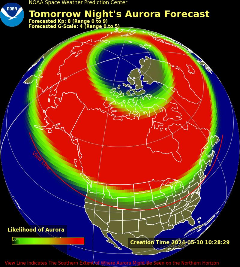
–Skies *may* clear enough to allow for potential Aurora viewing
–Forecasting auroras is stupid hard, but if it were me, I might make the effort to stay up later or get up earlier to see if I can get a glimpse as this is a rare multiple X-Class event
–Don’t be surprised if some tech goes wonky, either
–For Saturday after we hopefully (and likely) miss the Carrington Event Redux 165 years after the first one in 1859, a generally dry and partly sunny day awaits with highs in the upper 50s to low 60s
–Lows will drop into the low 40s as clouds increase
–An upper trough ambles eastward through New England and could produce a few showers on Sunday, but no washout is expected by any means
–Highs will again climb to either side of 60º with lows in the low 40s
–Early next week looks warmer as high pressure develops south of us, pushing temps into the 60s by Monday and low 70s by Tuesday
–Monday looks sunny, but clouds build Tuesday as another wave works into the region with potential for more showers by Tuesday night into Wednesday
–Drier air works in by Thursday with more sunshine and seasonable high temps in the upper 60s to low 70s
~~~~~~~~~~~~~~~~~~~~~~
YOUR MORNING DISCUSSION
~~~~~~~~~~~~~~~~~~~~~~
Good morning everybody, the Nutshell above will once again carry the load of today’s report, as aside from a couple showers in southern areas this morning, a few more Sunday, and another round of showers on Wednesday with no big warm ups, cool downs, washouts, or severe weather in sight, there isn’t much to discuss.
However, even though it’s not weather, we do have the strongest potential we’ve had in years to see the Aurora Borealis tonight into the pre-dawn hours of Saturday morning as a peak of Earth-directed X-Class flares flies by our planet.
These forecasts are exceedingly difficult to nail down, but with a drying trend overnight that could lead to better viewing, and a chance for the Aurora to be seen down into far southern New England, this might be a good night to try and catch glimpse.
I hope you have a great day!
>>> BE KIND <<<
“Hello babies. Welcome to Earth. It’s hot in the summer and cold in the winter. It’s round and wet and crowded. On the outside, babies, you’ve got a hundred years here. There’s only one rule that I know of, babies: Goddamn it, you’ve got to be kind.”
–Kurt Vonnegut
