~~~~~~~~~~~~~~~~~~~~~~
TABLE OF CONTENTS
* Daily Celestials (Sun/Moon Data)
* Weekly Weather Nutshell
* Morning Discussion
* TIP: Scroll below for sections, or read all
~~~~~~~~~~~~~~~~~~~~~~
YOUR DAILY CELESTIALS
~~~~~~~~~~~~~~~~~~~~~~
STAR:
–OUR STAR ROSE AT: 5:36am this morning
–OUR STAR SETS AT: 7:57pm this evening
–TOTAL DAYLIGHT TIME: 14 hours and 21 minutes
MOON:
–OUR MOON SETS AT: 9:07pm this evening
–MOON SET DIRECTION: West-Northwest
–OUR MOON RISES AT: 6:14am tomorrow morning
–MOON RISE DIRECTION: Northeast
–MOON PHASE: New Moon (0.2%)
~~~~~~~~~~~~~~~~~~~~~~
A NOTE FROM OUR SPONSOR
~~~~~~~~~~~~~~~~~~~~~~
Dave Hayes The Weather Nut is Sponsored by Individual Community Members, Patrons, and Tandem Bagel Company… No matter the weather, Tandem Bagel is always there for you at several valley locations to make your mornings brighter! With *New Pizza Bagels(!)*, along with bagels baked fresh daily (including Gluten-Free options), house-whipped cream cheese, coffee, and tons of lunch options, Tandem is the perfect quick stop for lunch, breakfast, or a coffee and bagel to go.
You can either A) visit them in Easthampton, Northampton, Hadley, Florence, and/or West Springfield, B) hire them to cater your next event, or C) use their super-streamlined online ordering tool by visiting their website and clicking the “Catering” or “Order Online” links.
~~~~~~~~~~~~~~~~~~~~~~
YOUR WEEKLY WEATHER NUTSHELL
~~~~~~~~~~~~~~~~~~~~~~
–Clouds increase this morning, showers already reaching into the Berkshires
–A couple of embedded thunderstorms move into the region between 7am-11am, with heavy rain in some spots
–Highs reach the mid 60s to mid 70s today in the pre-frontal moist environment
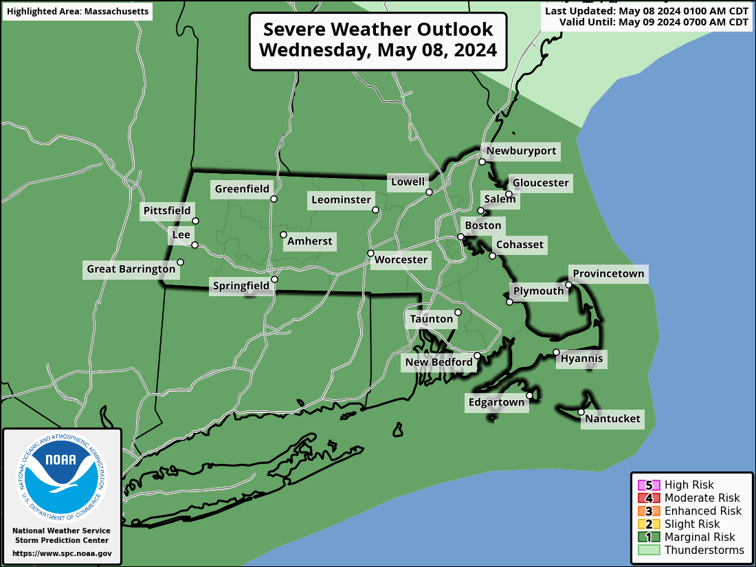
–Cold front moves through later this afternoon, with scattered showers and potential for a strong thunderstorm or two ahead of it
–With instability elevated today, better chance for larger hail vs. strong wind, but strong gusty wind can’t be ruled out either
–All activity winds down this evening, lows either side of 50º
–Partial sunshine is possible early Thursday, but the day is mostly cloudy, trending cloudier into afternoon
–Another wave ejects out of the Ohio Valley and passes south
–This bring more rainfall into the region by Thursday night into early Friday
–Highs in the 60s Thursday, lows in the low to mid 40s
–Upper trough swings into the northeast U.S. Friday through the weekend with more inclement weather at times
–Friday could produce another rainstorm with cool highs in the upper 40s to 50s
–In fact, some high terrain areas may dip into the mid 30s overnight with some showers ending as snow in the Berkshires or SVT!
–Saturday looks fairly dreary as the upper low pushes through pulses of light moisture, with drizzle and a few showers possible, highs mid to upper 50s all weekend long with more light showers possible Sunday
–We finally see this cold-season patterned upper low pass east by early next week with warming temps, but a few showers are still possible at that time
–I will update later on about afternoon storm potential
~~~~~~~~~~~~~~~~~~~~~~
YOUR MORNING DISCUSSION
~~~~~~~~~~~~~~~~~~~~~~
Good morning everybody, active weather is moving in first thing this morning with showers and a few thunderstorms on our doorstep. Some showers have already pushed into the Berkshires at 6:30am.
This instability burst will produce a wet morning commute for those of us traveling to work after the very early morning shift, so pack your rain gear if you’re heading out soon.
This first showery period lasts about 7am-11am from the Berkshires to CMass, and then we may see a few breaks of sun by mid day, with another round of scattered showers and thunderstorms moving into the region this afternoon with highs in the 60s at elevation and low to mid 70s in the valley points south and east.
The instability ahead of today’s incoming cold front will be mostly elevated, which will encourage convection (i.e. rising moist air) to be located higher up in the sky, closer to the freezing layer aloft, which will increase the chance for hail, with some hailstones forming to dime size or even quarter size this afternoon, along with potential for strong gusty winds.
This activity will wind down this evening, and we’ll get a break overnight and into the first part of Thursday as we dry out behind the cold front.
However, we’re now looking at two additional rainy systems, one for Thursday night into early Friday, and another by Friday afternoon, both ejecting east out of the Ohio Valley and bringing periods of steadier rainfall to the greater WMass region through Friday evening.
Highs are in the 60s Thursday, but much cooler on Friday, which looks like a raw, showery day, especially by afternoon as an upper low pulls into the region, and keeps our temps cooler through the weekend (mid to upper 50s Sat and Sun) with a chance for scattered showers or drizzle each day.
In fact, we may temps take a dip Friday night down into the mid 30s to low 40s, with potential for Friday showers ending as snow in parts of the high terrain either side of the valley, especially in SVT and the Berkshires, though no accumulation is expected at this time.
After the weekend, our lumbering, lazy, languishing, lackadaisical upper low limps off to the east, and allows milder temps to work back into the WMass region early next week, but we can’t shake the isolated/scattered shower threat for Monday just yet.
Stay tuned for updates with our storms today, and have a great day!
>>> BE KIND <<<
“Hello babies. Welcome to Earth. It’s hot in the summer and cold in the winter. It’s round and wet and crowded. On the outside, babies, you’ve got a hundred years here. There’s only one rule that I know of, babies: Goddamn it, you’ve got to be kind.”
–Kurt Vonnegut
