~~~~~~~~~~~~~~~~~~~~~~
TABLE OF CONTENTS
* Daily Celestials (Sun/Moon Data)
* Weekly Weather Nutshell
* Morning Discussion
* TIP: Scroll below for sections, or read all
~~~~~~~~~~~~~~~~~~~~~~
YOUR DAILY CELESTIALS
~~~~~~~~~~~~~~~~~~~~~~
STAR:
–OUR STAR ROSE AT: 5:39am this morning
–OUR STAR SETS AT: 7:55pm this evening
–TOTAL DAYLIGHT TIME: 14 hours and 16 minutes
MOON:
–OUR MOON SETS AT: 6:27pm this afternoon
–MOON SET DIRECTION: West-Northwest
–OUR MOON RISES AT: 5:05am tomorrow morning
–MOON RISE DIRECTION: East-Northeast
–MOON PHASE: Waning Crescent (4.2%)
~~~~~~~~~~~~~~~~~~~~~~
A NOTE FROM OUR SPONSOR
~~~~~~~~~~~~~~~~~~~~~~
Dave Hayes The Weather Nut is Sponsored by Individual Community Members, Patrons, and Tandem Bagel Company… No matter the weather, Tandem Bagel is always there for you at several valley locations to make your mornings brighter! With *New Pizza Bagels(!)*, along with bagels baked fresh daily (including Gluten-Free options), house-whipped cream cheese, coffee, and tons of lunch options, Tandem is the perfect quick stop for lunch, breakfast, or a coffee and bagel to go.
You can either A) visit them in Easthampton, Northampton, Hadley, Florence, and/or West Springfield, B) hire them to cater your next event, or C) use their super-streamlined online ordering tool by visiting their website and clicking the “Catering” or “Order Online” linkS.
~~~~~~~~~~~~~~~~~~~~~~
YOUR WEEKLY WEATHER NUTSHELL
~~~~~~~~~~~~~~~~~~~~~~
–Most of the rainfall (anywhere from a quarter inch to one and a quarter inches) is east of the region this morning
–A mostly cloudy day is on tap, with southerly flow, which warms us into the mid 60s to low 70s, possibly mid 70s if a period of sunshine opens up through the cloud deck
–A few scattered afternoon showers or a rumble of thunder are expected, but not everyone gets re-wettened (sorry for the non-words, it’s a habit)
–Flow turns west to northwest tonight as the front clears the region, and should dry us out with lows either side of 50º
–Any morning clouds clear out by Tuesday, as we soar well into the 70s under mostly sunny skies, with some folks hitting 80º
–Watch for a pollen spike if you suffer from allergies!
–Lows dip into low 50s as clouds increase at night
–Our weather deteriorates mid to late week as a pair of upper troughs eject east out of the northern Plains and head for New England bringing clouds, periods of rain, and progressively cooler temps
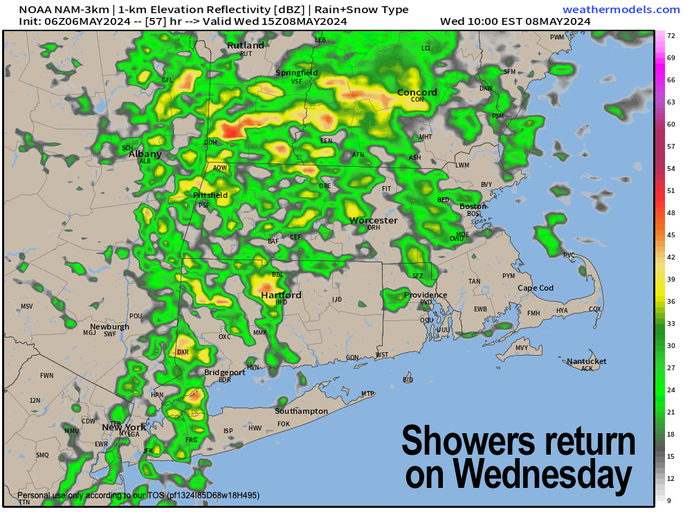
–Wednesday features the first frontal boundary passage and periods of rain with highs in the mid to upper 60s
–Thursday dries for the morning, but then another stronger storm pushes in for the afternoon and especially the evening into Friday
–Highs Thursday are in the low 60s, and highs Friday are even cooler into the 50s, with some upper 40s possible!
–The weekend doesn’t look super nice either with partial to mostly cloudy skies in the outlook and scattered showers possible with highs in the 50s to low 60s for highs
–A widespread 1-2.5″of rain looks probably between now and the end of this coming weekend
–Stay tuned for forecast refinements as we get closer
~~~~~~~~~~~~~~~~~~~~~~
YOUR MORNING DISCUSSION
~~~~~~~~~~~~~~~~~~~~~~
Good morning folks, we got a good drink of rain yesterday into last evening, and now those showers have pushed east ahead of a frontal boundary that will swing through later today with a few scattered showers or a rumble of thunder, especially along and south of the Pike. Highs will reach the mid 60s to low 70s.
We’ll dry the surface atmosphere out overnight and into Tuesday, with mostly sunny skies developing which will send our temps soaring well into the 70s, with a few very low 80s possible in the Springfield to Hartford stretch.
It’ll produce a pollen spike for sure, so sufferers need to be mindful, but if you can get outside, it would be advisable, as we’re going to be taking several steps down into a period of atmospheric inclemency mid to late week and into the weekend (meaning the weather’s gonna get bad).
We cloud up Tuesday night, as the first in a pair of upper troughs (i.e. areas aloft of lower than average pressures) approach New England, which will spawn a period of rainfall on Wednesday, likely arriving by late morning into the afternoon.
Highs in the mid to upper 60s Wednesday will fall to the 50s to low 60s on Thursday and then the upper 40s to 50s on Friday, so down, down, down we go in the Temperature Depahtment, though no freezes expected.
We dry Thursday morning, but a stronger storm looks to move in for Thursday later afternoon into Friday as a longer wet-weather period looms.
The weekend looks a bit drier, but scattered showers, as of now, are still possible each day with highs in the 50s on Saturday, and (hopefully climbing into) the 60s by Sunday.
Have a great day!
>>> BE KIND <<<
“Hello babies. Welcome to Earth. It’s hot in the summer and cold in the winter. It’s round and wet and crowded. On the outside, babies, you’ve got a hundred years here. There’s only one rule that I know of, babies: Goddamn it, you’ve got to be kind.”
–Kurt Vonnegut
