~~~~~~~~~~~~~~~~~~~~~~
TABLE OF CONTENTS
* Daily Celestials (Sun/Moon Data)
* Weekly Weather Nutshell
* Morning Discussion
* TIP: Scroll below for sections, or read all
~~~~~~~~~~~~~~~~~~~~~~
YOUR DAILY CELESTIALS
~~~~~~~~~~~~~~~~~~~~~~
STAR:
–OUR STAR ROSE AT: 5:48am this morning
–OUR STAR SETS AT: 7:47pm this evening
–TOTAL DAYLIGHT TIME: 13 hours and 59 minutes
MOON:
–OUR MOON SETS AT: 9:33am this morning
–MOON SET DIRECTION: Southwest
–OUR MOON RISES AT: 1:52am tomorrow morning
–MOON RISE DIRECTION: Southeast
–MOON PHASE: Waning Gibbous (71.7%)
~~~~~~~~~~~~~~~~~~~~~~
A NOTE FROM OUR SPONSOR
~~~~~~~~~~~~~~~~~~~~~~
Dave Hayes The Weather Nut is Sponsored by Individual Community Members, Patrons, and Tandem Bagel Company… No matter the weather, Tandem Bagel is always there for you at several valley locations to make your mornings brighter! With *New Pizza Bagels(!)*, along with bagels baked fresh daily (including Gluten-Free options), house-whipped cream cheese, coffee, and tons of lunch options, Tandem is the perfect quick stop for lunch, breakfast, or a coffee and bagel to go. Find them in Easthampton, Northampton, Hadley, Florence, and West Springfield, or use their super-streamlined online ordering tool by visiting their website.
~~~~~~~~~~~~~~~~~~~~~~
YOUR WEEKLY WEATHER NUTSHELL
~~~~~~~~~~~~~~~~~~~~~~
–As far as I can tell, today is going to be our pick of the week!
–However, pollen counts will be high, it’s always something here in New England!
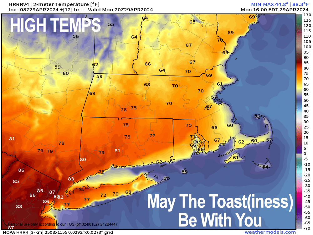
–Partly sunny for our Monday, dry (though a spot shower in northern CT is possible), with highs well into the 70s, except 60s in SVT, with a shot at 80º in northern CT
–A back door cold front starts to push into the region due to high pressure north of us overnight into Tuesday
–This will squeeze a few showers out over the region late tonight and into early Tuesday morning, with lows near 50º
–Tuesday is mostly cloudy with cooler highs in the upper 50s to mid 60s, so get outside today!
–Again, a few showers possible in the morning, and a better chance of showers Tuesday night into early Wednesday as a weak disturbance whips by
–Tuesday lows dip into the low 40s with low to mid 60s highs on Wednesday, which hopefully dries out later in the day
–Late week looks a bit warmer still, but I am always leery of lackadaisical frontal boundaries, so I’m punting on this period other than to say highs should be in the 60s to near 70º with a few showers possible Thursday, and drier by Friday (hopefully)
–The weekend now looks flipped on its head from earlier expectations, with a drier Satur-Day and some evening showers possible, with a wetter Sunday
–Highs should reside in the 60s
–Stay tuned for updates this week As The World Turns during The Days of Our Lives #SoapOpera
~~~~~~~~~~~~~~~~~~~~~~
YOUR MORNING DISCUSSION
~~~~~~~~~~~~~~~~~~~~~~
Good morning folks, I hope you had a great weekend, I had a stress dream all night, you ever have those? NO FUN, my friends, no fun.
Anyway, the short story in the Weather Department for the greater WMass region is that today is likely to be the best combination of toasty and dry with some sun all week long, so if you’re able (and don’t have bad allergies, given high pollen counts) get outside and soak up a quick early summer vibe, as it will likely be fleeting for the rest of this week as we sink back into springtime conditions.
Highs should climb well into the 70s today prior to a backdoor cold front dropping southwest into our region, and suppressing this early season warmth back into the MId-Atlantic and Ohio Valley regions, away from New England.
Still, all week should generally hang in the 60s for highs, with some rises to near or over 70º at times (especially by late week), but given this front some folks will hang in the upper 50s tomorrow/Tuesday.
As for wet weather, some showers will move in very late tonight into early Tuesday morning, with another round Tuesday night into early Wednesday as a disturbance whips by.
We can’t rule out a few showers on Thursday, but the next real chance at significant wet weather holds off until the weekend, and at this point it looks more like a Saturday night into Sunday affair.
Having said all of the above in the Nutshell and Discussion, our frontal boundary this week is carrying with it lots of uncertainty, mostly with temperature expectations, and to a lesser degree when we can expect showers, so please check back with me at the week goes along and I will keep you updated.
Have a great day!
>>> BE KIND <<<
“Hello babies. Welcome to Earth. It’s hot in the summer and cold in the winter. It’s round and wet and crowded. On the outside, babies, you’ve got a hundred years here. There’s only one rule that I know of, babies: Goddamn it, you’ve got to be kind.”
–Kurt Vonnegut
