TABLE OF CONTENTS
* Daily Celestials (Sun/Moon Data)
* Weekly Weather Nutshell
* Morning Discussion
* TIP: Scroll below for sections, or read all
~~~~~~~~~~~~~~~~~~~~~~
YOUR DAILY CELESTIALS
~~~~~~~~~~~~~~~~~~~~~~
STAR:
–OUR STAR ROSE AT: 6:38am this morning
–OUR STAR SETS AT: 7:12pm this evening
–TOTAL DAYLIGHT TIME: 12 hours and 34 minutes
MOON:
–OUR MOON RISES AT: 10:56pm tonight
–MOON RISE DIRECTION: East-Southeast
–OUR MOON SETS AT: 8:23am tomorrow morning
–MOON SET DIRECTION: West-Southwest
–MOON PHASE: Waning Gibbous (91.0%)
~~~~~~~~~~~~~~~~~~~~~~
A NOTE FROM OUR SPONSOR
~~~~~~~~~~~~~~~~~~~~~~
Dave Hayes The Weather Nut is Sponsored by Individual Community Members, Patrons, and Tandem Bagel Company… No matter the weather, Tandem Bagel is always there for you at several valley locations to make your mornings brighter! With *New Pizza Bagels(!)*, along with bagels baked fresh daily (including Gluten-Free options), house-whipped cream cheese, coffee, and tons of lunch options, Tandem is the perfect quick stop for lunch, breakfast, or a coffee and bagel to go. Find them in Easthampton, Northampton, Hadley, Florence, and West Springfield, or use their super-streamlined online ordering tool by visiting their website.
~~~~~~~~~~~~~~~~~~~~~~
YOUR WEEKLY WEATHER NUTSHELL
~~~~~~~~~~~~~~~~~~~~~~
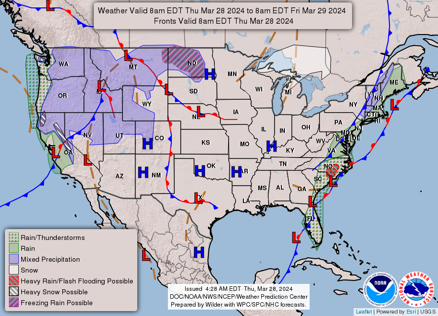
–Low pressure is developing way south over Florida and Georgia
–This will strengthen and lift northeast to the North Carolina coastline
–It will then sweep northeast well south of Nantucket and bomb out over Nova Scotia and New Brunswick by tomorrow
–Additionally, a strong upper jet will act on this stalled front over the eastern seaboard and all of these factors will generate periods of rain today, hedaviest to the east of I-91
–At times there will be showers, and other times (especially afternoon and tonight) rain will be steadier and/or heavier, and more stratiform in its layout across the region
–Generally a half inch to 1.25″ will fall west of the I-91 corridor, and more like .75-2″ will fall east of it, with best chance for isolated flooding as per the NWS Flood Watches in CMass and northeast CT closer to the heavier precipitation shield
–Highs will reach the 45-50º range, with lows in the mid to upper 30s
–Overnight, as the rain tapers off and the storm pulls away after midnight, we may flip to snow briefly in the high terrain and can’t rule out some wet snow coatings in spots
–For Friday, morning showers will end and drying will move in from the west
–We should start mostly cloudy, but end partly sunny as northwest winds sweep in behind the departing storm and frontal boundary
–Gusts should reach up to 25-45mph at times Friday later afternoon and overnight into early Saturday morning
–Wind Advisories may need to be hoisted for some areas
–Lows Friday night drop into the upper 20s to low 30s with Saturday highs in the upper 40s to low 50s under mostly sunny skies
–A weak blip of a wave whips through Saturday night with a spot shower and lows in the low 30s, otherwise, Easter Sunday should develop into a partly sunny day with highs in the upper 40s to low 50s and lows in the low 30s
–Monday looks like another mild fair weather day, but by Tuesday through Thursday, unsettled weather returns in the form of more rainfall, but some high-elevation snow mischief may be afoot, so stay tuned for updates!
~~~~~~~~~~~~~~~~~~~~~~
YOUR MORNING DISCUSSION
~~~~~~~~~~~~~~~~~~~~~~
Good morning everybody, a rainy day and night is on the menu, and a gusty Friday afternoon into Saturday morning is, too.
We a front draped up and down the entire eastern seaboard of the United States that has copious moisture being drawn up its east side to the north into New England today, as a surface low pushes into North Carolina and south of Nantucket.
Therefore, a showery and rainy day develops, with more breaks in the action well west of the I-91 corridor in parts of the Berkshires, SVT and Litchfield County which will be farther removed from the best lift and moisture load.
Expect periods of rain all day, which should be come steadier/heavier along and east of the I-91 corridor later this afternoon and evening, before tapering off Friday morning, possibly ending as a bit of snow.
Friday morning transitions from mostly cloudy to partly sunny late, but most notably we should see northwest winds sweeping in behind the front, racing to catch up with and funnel into a bombing low center over western Nova Scotia which will bring accumulating snow to far east Maine and New Brunswick, Canada.
Gusts will get up to 25-45mph by Friday afternoon, night, and Saturday morning, and slacken by Saturday afternoon, though it should remain breezy all day Saturday.
A weak wave brings a spot shower late Saturday night, otherwise Sunday should be mild and partly sunny, which lasts into Monday with even more sunshine.
Expect unsettled conditions as a multi-stage event may set up that brings rain AND possibly some wet snow Tuesday into Thursday, but that’s a long ways off, with a prognostication that will need multiple refinements to produce more clarity as we get closer to that period of time.
Have a great day and pack the umbrellas!
>>> BE KIND <<<
“Hello babies. Welcome to Earth. It’s hot in the summer and cold in the winter. It’s round and wet and crowded. On the outside, babies, you’ve got a hundred years here. There’s only one rule that I know of, babies: Goddamn it, you’ve got to be kind.”
–Kurt Vonnegut
