CONNECT WITH COMMUNITY – You get the continued cultivation of a local and regional online community around severe weather events where you can connect around weather that affects everyone.
SECURELY BECOME A 2024 DHTWN SUPPORTER TODAY
We’re 69% of the way to the goal with 5 days left!
~~~~~~~~~~~~~~~~~~~~~~
TABLE OF CONTENTS
* Daily Celestials (Sun/Moon Data)
* Weekly Weather Nutshell
* Morning Discussion
* TIP: Scroll below for sections, or read all
~~~~~~~~~~~~~~~~~~~~~~
YOUR DAILY CELESTIALS
~~~~~~~~~~~~~~~~~~~~~~
STAR:
–OUR STAR ROSE AT: 6:52am this morning
–OUR STAR SETS AT: 7:03pm this evening
–TOTAL DAYLIGHT TIME: 12 hours and 11 minutes
MOON:
–OUR MOON RISES AT: 2:32pm this afternoon
–MOON RISE DIRECTION: East-Northeast
–OUR MOON SETS AT: 5:37am tomorrow morning
–MOON SET DIRECTION: West-Northwest
–MOON PHASE: Waxing Gibbous (80.3%)
~~~~~~~~~~~~~~~~~~~~~~
A NOTE FROM OUR SPONSOR
~~~~~~~~~~~~~~~~~~~~~~
Dave Hayes The Weather Nut is Sponsored by Individual Community Members, Patrons, and Tandem Bagel Company… No matter the weather, Tandem Bagel is always there for you at several valley locations to make your mornings brighter! With *New Pizza Bagels(!)*, along with bagels baked fresh daily (including Gluten-Free options), house-whipped cream cheese, coffee, and tons of lunch options, Tandem is the perfect quick stop for lunch, breakfast, or a coffee and bagel to go. Find them in Easthampton, Northampton, Hadley, Florence, and West Springfield, or use their super-streamlined online ordering tool by visiting their website.
~~~~~~~~~~~~~~~~~~~~~~
YOUR WEEKLY WEATHER NUTSHELL
~~~~~~~~~~~~~~~~~~~~~~
–Morning snow showers and flurries in SVT and the Berkshires end
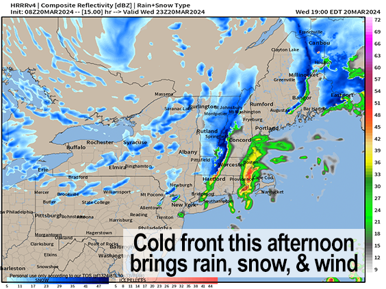
–A partly sunny day develops ahead of a potent incoming cold front this late afternoon and evening
–Highs will reach the mid 40s to low 50s under partly sunny skies (more clouds over the hills/mountains) with light southwest wind
–By mid to late afternoon a Clipper low will be passing just north of us, cranking up as it sets up to paste Maine with some briefly heavy weather
–As it does so, it will swing its potent cold front through the greater WMass region between 5-9pm generally speaking
–It’s a mild day, so many in the low elevations and valley will see moderate to briefly heavy rain showers move through with graupel mixed in as cold air aloft sweeps overhead
–But in the high terrain of the Berkshires, hilltowns, and SVT, we could see rain changing to snow showers, or even snow squalls as temps tank
–This could produce slippery travel by later evening, and lowered visibility in parts of northern MA (northern Berks, Franklin County, northern Worcester County) up into SVT & SWNH
———————————–
SECURELY BECOME A 2024 DHTWN SUPPORTER TODAY
We’re 69% of the way to the goal with 5 days left!
~~~~~~~~~~~~~~~~~~~~~~
–We could even get some thunder through our region as the lapse rates will be strong with this front!
–Strong cold air advection sweeps in behinid thee front with scattered snow showers
–Accumulating snow is expected in northwest MA up into SVT and SWNH of mostly a coating to 2″, but 2-5″ is expected in the southern Greens, with coatings in northern CMass by morning
–Lows will tank into the low to mid 20s, with some upper teens in SVT
–Wind will be the other factor, both with and behind this front, with westerly to northwesterly wind gusting 30-45mph
–This will produce a very chilly start Thursday morning and Friday morning
–Thursday should feature clearing and mostly sunny skies, but it will be cold with highs in the 30s and wind chills in the teens and 20s all day with strong gusts at times
–Gusty conditions should continue for part of Thursday night, and lows will drop into the upper teens to low 20s with wind chills into the single digits
–Friday looks lovely with mostly sunny skies and highs either side of 40º as high pressure briefly builds in
–However, clouds will reform Friday night, and snow will move back into our region during the pre-dawn hours with lows in the upper 20s to low 30s
–This will be thanks to a southern stream coastal low phasing a bit with an upper trough that will swing east toward the eastern Great Lakes
–Saturday morning looks snowy for a time along/north of the Route 2 corridor, with rain/snow mix south of there turning to rain for Saturday and Saturday night with highs in the upper 30s to mid 40s and lows near freezing, with a change back to snow possible before ending
–Sunday to Tuesday looks like fair weather at the moment with highs in the 40-45º range
~~~~~~~~~~~~~~~~~~~~~~
YOUR MORNING DISCUSSION
~~~~~~~~~~~~~~~~~~~~~~
Good morning everybody, I put a lot more time into the Nutshell this morning, so please read through that, and know that I will post a discussion of our upcoming Wednesday afternoon through Saturday night stretch of busier weather this afternoon by about 4 or 5pm before the cold front sweeps in, so please look for that update.
Have a great day, and if you’re able and want to see my work continue here throughout 2024, it’s your modest support that keeps me on this job for you and yours (options include Cards, PayPal, Venmo, or Check, even $10 helps!)
———————————–
SECURELY BECOME A 2024 DHTWN SUPPORTER TODAY
We’re 69% of the way to the goal with 5 days left!
~~~~~~~~~~~~~~~~~~~~~~
>>> BE KIND <<<
“Hello babies. Welcome to Earth. It’s hot in the summer and cold in the winter. It’s round and wet and crowded. On the outside, babies, you’ve got a hundred years here. There’s only one rule that I know of, babies: Goddamn it, you’ve got to be kind.”
–Kurt Vonnegut
