WE’RE ABOUT 55% TO THE
4% READER SUPPORT GOAL (2 WEEKS LEFT)
–I’ve reported on every storm for over 11 years straight
–Many of you have told me you rely on me
–Now I need to rely on your support to sustain my work
SECURELY BECOME A 2024 DHTWN SUPPORTER TODAY
(Options include Cards, PayPal, Venmo, Check)
~~~~~~~~~~~~~~~~~~~~~~
TABLE OF CONTENTS
* Daily Celestials (Sun/Moon Data)
* Weekly Weather Nutshell
* Morning Discussion
* TIP: Scroll below for sections, or read all
~~~~~~~~~~~~~~~~~~~~~~
YOUR DAILY CELESTIALS
~~~~~~~~~~~~~~~~~~~~~~
STAR:
–OUR STAR WILL RISE AT: 7:09am this morning
–OUR STAR WILL SET AT: 6:51pm this evening
–TOTAL DAYLIGHT TIME: 11 hours and 42 minutes
MOON:
–OUR MOON WILL SET AT: 7:27pm this afternoon
–MOON SET DIRECTION: West
–OUR MOON WILL RISE AT: 7:52am tomorrow morning
–MOON RISE DIRECTION: East
–MOON PHASE: Waxing Crescent (0.1%)
~~~~~~~~~~~~~~~~~~~~~~
>>> A NOTE FROM OUR SPONSOR <<<
Dave Hayes The Weather Nut is Sponsored by Individual Community Members, Patrons, and Gerard, Ghazey & Bates, P.C. GGBPC is a Northampton-based law firm regarded as the voice of pragmatic and well-reasoned estate planning, elder law and tax guidance in Western Massachusetts. The firm specializes in estate planning law, and expertly handles other matters such as Elder Law, Tax Law, as well as Real Estate purchase, sales, and refinance transactions. Contact GGBPC today to see how they can help!
~~~~~~~~~~~~~~~~~~~~~~
YOUR WEEKLY WEATHER NUTSHELL
~~~~~~~~~~~~~~~~~~~~~~
–Rain, ice, and snow showers continue to wind down as our storm pulls northeast through central MA and away into Maine
–Some partial sunshine at times today, with more clouds than sun
–Temps in the 30s to low 40s this morning rise to the low to mid 40s later, but hang in the 30s over southern VT
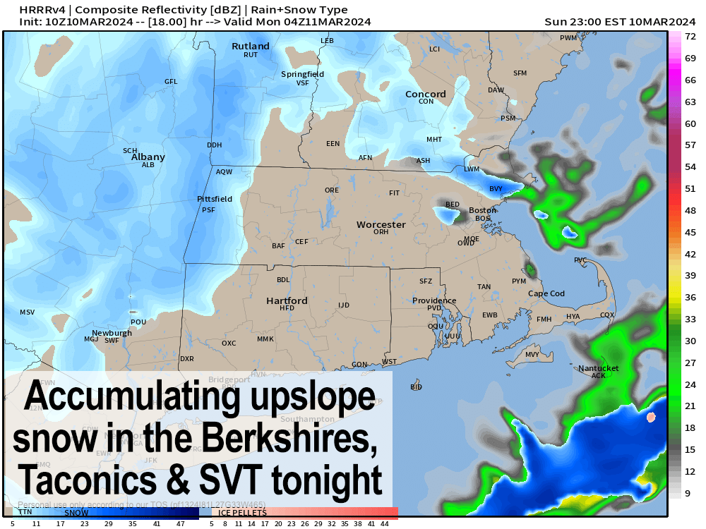
–By early afternoon, upslope snow showers redevelop over SVT and start pressing into the northern Berkshires
–An area of mixed rain, snow and graupel showers will dive southeast through far southwest MA and northwest CT by later afternoon as wave runs through that area
–Northwest winds pick up today and gust 25-40mph at times
–Snow showers will continue to develop this afternoon and eveninig in SVT and the Berkshires and Taconics, bleeding into the northern Litchfields and western hilltowns of WMass
–Lows will drop into the 25-30º range, with highs either side of 40º tomorrwo
–Winter Weather Advisories are up tonight for accumulating snow of 2-5″ in the Berkshires and central Taconics through Monday morning
———
SECURELY BECOME A 2024 DHTWN SUPPORTER TODAY
(Options include Cards, PayPal, Venmo, Check)
———
–Winter Storm Warnings are up tonight for SVT with an additional 5-10″ possible through Monday morning
–An additional coating to 2″ is possible in the western hilltowns, eastern Windham County VT and northern Litchfield County from this afternoon into Monday morning
–Snow showers should abate into the afternoon, but wind will not!
–Wind Advisories are up for much of Monday as the upper low pushes much colder air aloft into our region, which will allow stronger winds to mix to the ground, with gusts of 40-60mph possible on Monday
–This could cause some outages and blowing snow, lowering visibility during travel
–Lastly, Flood Warnings are renewed for northern CT and the CT River at Thompsonville and Hartford where additional minor flooding is happening and forecast
–Monday night should feature clearing with blustery conditions and lows in the 20s before we turn a page and get some milder temps with highs in the 50s Tuesday through Thursday with more in the way of sunshine
–Thereafter another unsettled period may arrive Thursday night into the weekend with at least a couple of more showery chances
~~~~~~~~~~~~~~~~~~~~~~
YOUR MORNING DISCUSSION
~~~~~~~~~~~~~~~~~~~~~~
Good morning folks, please let me know how much snow you saw yesterday, if any.
I did see a report last night in SVT of 5″, but am curious as to how the snow and ice laid out in your hills and dales.
The Nutshell above has lots of details for what’s coming, but the bottom line is that more accumulating snowfall is coming for the Berkshires, Taconics and SVT this afternoon and overnight into Monday, as well as plenty of wind, which will peak tomorrow morning as the upper low passes east and overhead.
Additional outages are possible (I saw about 1000 last night in SVT) due to high wind gusts of 40-60mph on Monday morning, with a slight slackening in the afternoon.
I will post a more detailed discussion by late afternoon with an update of expected weather conditions for tonight through Monday.
Have a great day and if you depend on my work each year, please chip in whatever is comfortable for you at the secure link below so I can continue through 2024… even $5 helps, thank you…
SECURELY BECOME A 2024 DHTWN SUPPORTER TODAY
(Options include Cards, PayPal, Venmo, Check)
>>> BE KIND <<<
“Hello babies. Welcome to Earth. It’s hot in the summer and cold in the winter. It’s round and wet and crowded. On the outside, babies, you’ve got a hundred years here. There’s only one rule that I know of, babies: Goddamn it, you’ve got to be kind.”
–Kurt Vonnegut
