RE: Relying on Each Other…
–The Goal: 4% reader contribution at any level, even $5 or $2/month (we’re 31% there, 69% to reach the goal)
–I care about your safety and of those you love
–I work to be as accurate, helpful, and interactive as I can
–Many of you have told me you rely on me because I show up
–Now I must rely on you for support to sustain my work
SECURELY BECOME A 2024 DHTWN SUPPORTER TODAY
(options include Cards, PayPal, Venmo, or Check)
~~~~~~~~~~~~~~~~~~~~~~
TABLE OF CONTENTS
* Daily Celestials (Sun/Moon Data)
* Weekly Weather Nutshell
* Morning Discussion
* TIP: Scroll below for sections, or read all
~~~~~~~~~~~~~~~~~~~~~~
YOUR DAILY CELESTIALS
~~~~~~~~~~~~~~~~~~~~~~
STAR:
–OUR STAR ROSE AT: 6:24am this morning
–OUR STAR SETS AT: 5:41pm this evening
–TOTAL DAYLIGHT TIME: 11 hours and 17 minutes
MOON:
–OUR MOON SETS AT: 8:51am this morning
–MOON SET DIRECTION: West-Southwest
–OUR MOON RISES AT: 12:04am tomorrow morning
–MOON RISE DIRECTION: East-Southeast
–MOON PHASE: Waning Gibbous (71.1%)
~~~~~~~~~~~~~~~~~~~~~~
A NOTE FROM OUR SPONSOR
~~~~~~~~~~~~~~~~~~~~~~
Dave Hayes The Weather Nut is Sponsored by Individual Community Members, Patrons, and Tandem Bagel Company… No matter the weather, Tandem Bagel is always there for you at several valley locations to make your mornings brighter! With *New Pizza Bagels(!)*, along with bagels baked fresh daily (including Gluten-Free options), house-whipped cream cheese, coffee, and tons of lunch options, Tandem is the perfect quick stop for lunch, breakfast, or a coffee and bagel to go. Find them in Easthampton, Northampton, Hadley, Florence, and West Springfield, or use their super-streamlined online ordering tool by visiting their website.
~~~~~~~~~~~~~~~~~~~~~~
YOUR WEEKLY WEATHER NUTSHELL
~~~~~~~~~~~~~~~~~~~~~~
–A cold start with temps in the teens and 20s begets a lovely sunny day with highs either side of 40º and light southwest wind
–Lows tonight drop to near 30º as clouds increasee
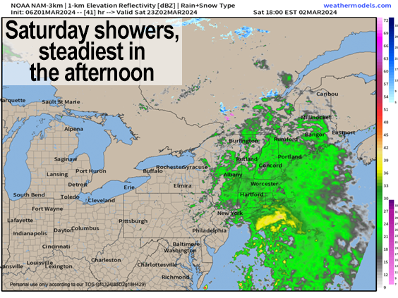
–Low pressure and a warm front approach tomorrow with potential for scattered early morning wintry mix showers in northern MA, SVT, SWNH and the Berkshires, and rain elsewhere
–Any mix goes to plain rain, and steadiest rain moves through during the afternoon and evening
–Highs tomorrow in the 40s, lows near 40º with showers ending
–Sunday looks mostly cloudy with the storm stalling off the coast, but milder highs climb into the mid 50s
–A bit more sunshine develops for Monday into Tuesday with highs in the 55-60º range prior to another storm approaching by mid-week
–As of now, Wednesday is looking rainy, with a chance for another rainstorm next Friday before we cool things down for next weekend
~~~~~~~~~~~~~~~~~~~~~~
YOUR MORNING DISCUSSION
~~~~~~~~~~~~~~~~~~~~~~
Good morning everybody, welcome to March, which arrives with a lovely, seasonable, sunny, peaceful, glorious day to be alive in our solar system, galaxy and Universe, rejoice!
There’s lots of problems in life and in the world, which will never change, but in the midst of those challenges we’re each responsible for sprinkling in self-generated moments of appreciation, simple happiness for 10 or 15 seconds, and we can do that by consciously becoming grateful for the little things that go right in a day, like the sunshine, or a nice cup of tea, or hearing a piece of music, or seeing a handsome tree, or sharing a laugh or good conversation with a friend.
I wish all of that and more for you today and every day.
Getting back to the weather, it’ll be quite seasonable with highs either side of 40º as temps begin to come up due to nearby strong high pressure strengthening to our south, initiating southwest flow. Wind will finally be light, and it’ll be a nice calm AFTER the storm.
For tonight, lows dip into the upper 20s to low 30s with clouds increasing as low pressure and a warm front tracks northeast toward New England.
This is a weaker system, no real wind to speak of with it, but it will push some scattered rain and mixed showers towards us as early as early Saturday morning, so if you hear some ice pellet pings or see some falling snowflake lilts in northern MA, the Berkshires, or SVT/SWNH, don’t be surprised.
Temps come up into the 40s tomorrow, and so everything goes to rain if we even get some frozen precip, and the steadiest rain falls in the afternoon into the evening before quitting late. Lows will hang near 40º.
Sunday through Tuesday (for the WMass region, for now) look partly sunny to mostly cloudy, but milder and mostly dry, though a spot shower can’t be ruled out during this period.
Highs will reach the mid 50s by Sunday, and then the 55-60º range Monday into Tuesday if we can get some sunshine to poke through the cloud decks.
By the middle of next week, another storm approaches with more rainfall, with another signal by end of the week prior to a cool down, so I’d say Saturday, Wednesday and next Friday are the wet weather days to watch, but no washouts expected, and I will keep you updated the whole way.
Have a great day, and if you depend on this community weather resource, you help collectively support my work during my 10th Annual Support Drive at the secure link below as I’m still 69% away from reaching my annual goal of 4% of readers donating whatever they can. Thank you!
———————————–
SECURELY BECOME A 2024 DHTWN SUPPORTER TODAY
(options include Cards, PayPal, Venmo, or Check)
~~~~~~~~~~~~~~~~~~~~~~
>>> BE KIND <<<
“Hello babies. Welcome to Earth. It’s hot in the summer and cold in the winter. It’s round and wet and crowded. On the outside, babies, you’ve got a hundred years here. There’s only one rule that I know of, babies: Goddamn it, you’ve got to be kind.”
–Kurt Vonnegut
