———————————–
RE: Relying on Each Other…
–The Goal: 4% reader contribution (we’re 30% there, 70% to reach the goal)
–I care about your safety and of those you love
–I work to be as accurate, helpful, and interactive as I can
–Many of you have told me you rely on me because I show up
–Now I must rely on you for support to sustain my work
SECURELY BECOME A 2024 DHTWN SUPPORTER TODAY
(Options include Cards, PayPal, Venmo, Check)
~~~~~~~~~~~~~~~~~~~~~~
TABLE OF CONTENTS
* Daily Celestials (Sun/Moon Data)
* Weekly Weather Nutshell
* Morning Discussion
* TIP: Scroll below for sections, or read all
~~~~~~~~~~~~~~~~~~~~~~
YOUR DAILY CELESTIALS
~~~~~~~~~~~~~~~~~~~~~~
STAR:
–OUR STAR ROSE AT: 6:26am this morning
–OUR STAR SETS AT: 5:39pm this evening
–TOTAL DAYLIGHT TIME: 11 hours and 13 minutes
MOON:
–OUR MOON RISES AT: 10:57pm this evening
–MOON RISE DIRECTION: East-Southeast
–OUR MOON SETS AT: 8:51am tomorrow morning
–MOON SET DIRECTION: West-Southwest
–MOON PHASE: Waning Gibbous (79.5%)
~~~~~~~~~~~~~~~~~~~~~~
A NOTE FROM OUR SPONSOR
~~~~~~~~~~~~~~~~~~~~~~
Dave Hayes The Weather Nut is Sponsored by Individual Community Members, Patrons, and Tandem Bagel Company… No matter the weather, Tandem Bagel is always there for you at several valley locations to make your mornings brighter! With *New Pizza Bagels(!)*, along with bagels baked fresh daily (including Gluten-Free options), house-whipped cream cheese, coffee, and tons of lunch options, Tandem is the perfect quick stop for lunch, breakfast, or a coffee and bagel to go. Find them in Easthampton, Northampton, Hadley, Florence, and West Springfield, or use their super-streamlined online ordering tool by visiting their website.
~~~~~~~~~~~~~~~~~~~~~~
YOUR WEEKLY WEATHER NUTSHELL
~~~~~~~~~~~~~~~~~~~~~~
–Partly to mostly sunny today
–Highs only reach the mid 20s to mid 30s from north to south
–Wind Advisories recently expired
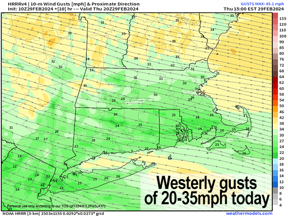
–Winds will still gust 20-35mph today into the first part of tonight, but a bit less than expected
–Gusts since midnight have peaked in the 40-55mph range
–A 63mph gust was measured at Pittsfield Airport last night
–Almost 20000 outages continue this morning across the greater WMass region with about 10000 in WMass & CMass combined
–Some lake effect snow showers or flurries will dot the Taconics and Berkshires into the Litchfields today, and may spill over the ridge into the western hilltowns and Pioneer Valley
–Winds continues into tonight, but slackens into the pre-dawn hours of Friday morning
———————————–
SECURELY BECOME A 2024 DHTWN SUPPORTER TODAY
~~~~~~~~~~~~~~~~~~~~~~
–Partly cloudy skies expected with lows in the upper teens to low 20s
–Friday is lovely with highs in the 40s under sunny skies and light southwest wind, with lows near freezing as clouds increase
–By very early Saturday morning, another warm front pushes our way with precipitation
–This may arrive early enough to start off as a brief period of snow or ice, but should quickly change to rain with showers expected for Saturday
–Highs likely reach the 45-50º range, with showers ending at night
–Thereafter, considerable uncertainty remains for the Sunday to Tuesday timeframe as a coastal low will slow or stall to our south
–Mild temps are expected, probably exceeding 50º, but precipitation timing and intensity will need to be further refined in later reports
~~~~~~~~~~~~~~~~~~~~~~
YOUR MORNING DISCUSSION
~~~~~~~~~~~~~~~~~~~~~~
Good morning everybody, that was quite the front that came through last night, thanks very much for all of your reports!
We’ve got some lake effect snow showers or flurries in the Berkshires and Taconics this morning, but otherwise precipitation has exited east and we saw about half an inch to 1.5″ of rainfall yesterday, with only coatings of snow for the most part, where it did accumulate.
We still have almost 20000 outages across my coverage area, so my statement of thousands being without power due to this frontal passage was no exaggeration, with about 8000 in WMass alone.
Westerly gusts of 20-35mph will not help power restoration matters today, but at least it’s a good 10mph less than what was expected as of yesterday.
As for our weather going forward, the Nutshell above covers the most important points.
The bottom line is that we’re cold and blustery today and tonight, and then we get a lovely and mostly seasonable Friday followed by a showery Saturday, with potential for more unsettled weather Sunday into early next week depending on how our stalling coastal low behaves, which I should know more about as we get closer to that timeframe.
At least temps look mild for that Sunday to early next week period, with highs most likely in the low to mid 50s with continued southwest flow.
Have a great day, and if you depend on this community weather resource, you help collectively support my work during my 10th Annual Support Drive at the secure link below as I’m still 70% away from reaching my annual goal of 4% of readers donating whatever they can.
It’s you that keeps these reports churning! (options include Cards, PayPal, Venmo, or Check, thank you!)
———————————–
SECURELY BECOME A 2024 DHTWN SUPPORTER TODAY
~~~~~~~~~~~~~~~~~~~~~~
>>> BE KIND <<<
“Hello babies. Welcome to Earth. It’s hot in the summer and cold in the winter. It’s round and wet and crowded. On the outside, babies, you’ve got a hundred years here. There’s only one rule that I know of, babies: Goddamn it, you’ve got to be kind.”
–Kurt Vonnegut
