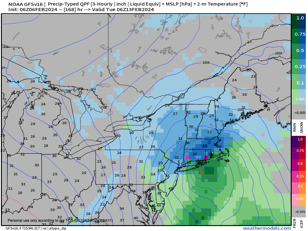
Possible Snowstorm Next Tues
TABLE OF CONTENTS
* Daily Celestials (Sun/Moon Data)
* Weekly Weather Nutshell
* Morning Discussion
* TIP: Scroll below for sections, or read all
~~~~~~~~~~~~~~~~~~~~~~
YOUR DAILY CELESTIALS
~~~~~~~~~~~~~~~~~~~~~~
STAR:
–OUR STAR ROSE AT: 6:58am this morning
–OUR STAR SETS AT: 5:10pm this evening
–TOTAL DAYLIGHT TIME: 10 hours and 12 minutes
MOON:
–OUR MOON SETS AT: 1:02pm this afternoon
–MOON SET DIRECTION: Southwest
–OUR MOON RISES AT: 5:37am tomorrow morning
–MOON RISE DIRECTION: Southeast
–MOON PHASE: Waning Crescent (16.2%)
~~~~~~~~~~~~~~~~~~~~~~
A NOTE FROM OUR SPONSOR
~~~~~~~~~~~~~~~~~~~~~~
Dave Hayes The Weather Nut is Sponsored by Individual Community Members, Patrons, and Tandem Bagel Company… No matter the weather, Tandem Bagel is always there for you at several valley locations to make your mornings brighter! With bagels baked fresh daily (including Gluten-Free options), house-whipped cream cheese, coffee, and tons of lunch options, Tandem is the perfect quick stop for lunch, breakfast, or a coffee and bagel to go. Find them in Easthampton, Northampton, Hadley, Florence, and West Springfield, or use their super-streamlined online ordering tool by visiting their website: https://www.tandembagelco.com
~~~~~~~~~~~~~~~~~~~~~~
YOUR WEEKLY WEATHER NUTSHELL
~~~~~~~~~~~~~~~~~~~~~~
–More sunshine today, with less wind, highs in the 30s
–Some clouds build from an ocean storm into parts of CMass and northeast CT later this afternoon and overnight
–Lows drop to the upper teens to low 20s
–More sunshine on Wednesday with some morning clouds east of the I-91 corridor
–Highs make it up to either side of 40º, with lows in the low to mid 20s
–Thursday represents our less full-sun day with highs climbing into the low to mid 40s as an upper ridge builds east into the eastern seaboard, with lows in the mid to upper 20s
–Clouds increase on Friday with a warm front approaching with highs reaching well into the 40s
–Clouds thicken at night with a shower possible, but we’ll be well into the mild sector on Saturday with highs in the low to mid 50s!
–This will also be accompanied by some scattered rain showers as a cold front approaches for Sunday
–Sunday is less mild, but still in the 40s with mostly cloudy skies
–Then we turn to the early week period when an upper trough may be digging iinto the region with colder air moving in
–This may combine with a southern stream system that could pass to our south and strengthen, with potential for a snowstorm here on Tuesday, though it’s a LOW chance at the moment, but something that bears watching
~~~~~~~~~~~~~~~~~~~~~~
YOUR MORNING DISCUSSION
~~~~~~~~~~~~~~~~~~~~~~
Good morning everybody, we continue to enjoy this much-needed sunny, fair weather period with temperate days and chilly nights/mornings.
We’ve got at least three more days during which our star should dominate our cosmic window (a/k/a “the sky”), though a few clouds from a backing ocean storm that has hammered Nova Scotia with feet of snow will bring some clouds to parts of Worcester County MA and Windham County CT later today and overnight.
Aside from that, it’s mostly sunny through Thursday before we get back into the clouds starting on Friday through the weekend and possibly into early next week as we deal with a warm front Friday, a cold front and some showers Saturday, an upper trough impinging on the area Sunday/Monday and then a potential winter storm for Tuesday.
Changes are afoot, but for the next few days, niceness abounds.
Please read the Nutshell section above for details, and have a great day!
>>> BE KIND <<<
“Hello babies. Welcome to Earth. It’s hot in the summer and cold in the winter. It’s round and wet and crowded. On the outside, babies, you’ve got a hundred years here. There’s only one rule that I know of, babies: Goddamn it, you’ve got to be kind.”
–Kurt Vonnegut
