
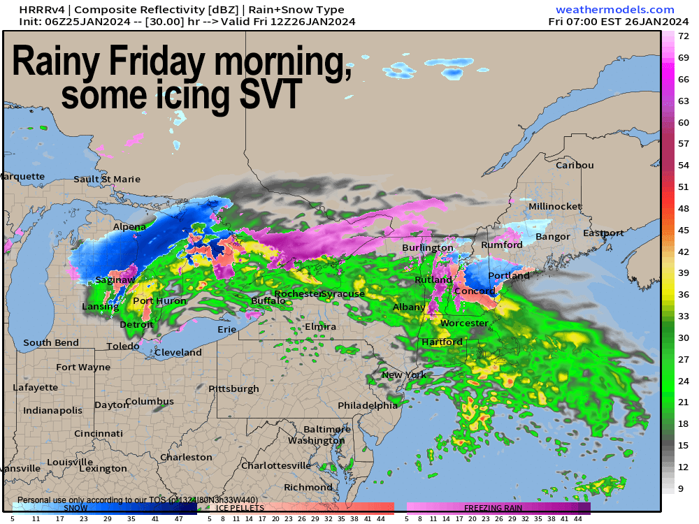
Rainy Friday morning
TABLE OF CONTENTS
* Daily Celestials (Sun/Moon Data)
* Weekly Weather Nutshell
* Morning Discussion
* TIP: Scroll below for sections, or read all
~~~~~~~~~~~~~~~~~~~~~~
YOUR DAILY CELESTIALS
~~~~~~~~~~~~~~~~~~~~~~
STAR:
–OUR STAR RISES AT: 7:10am this morning
–OUR STAR SETS AT: 4:55pm this evening
–TOTAL DAYLIGHT TIME: 9 hours and 45 minutes
MOON:
–OUR MOON RISES AT: 4:45pm this afternoon
–MOON RISE DIRECTION: East-Northeast
–OUR MOON SETS AT: 8:03am tomorrow morning
–MOON SET DIRECTION: West-Northwest
–MOON PHASE: Full Wolf Moon
~~~~~~~~~~~~~~~~~~~~~~
A NOTE FROM OUR SPONSOR
~~~~~~~~~~~~~~~~~~~~~~
Dave Hayes The Weather Nut is Sponsored by Individual Community Members, Patrons, and Tandem Bagel Company… No matter the weather, Tandem Bagel is always there for you at several valley locations to make your mornings brighter! With bagels baked fresh daily (including Gluten-Free options), house-whipped cream cheese, coffee, and tons of lunch options, Tandem is the perfect quick stop for lunch, breakfast, or a coffee and bagel to go. Find them in Easthampton, Northampton, Hadley, Florence, and West Springfield, or use their super-streamlined online ordering tool by visiting their website.
~~~~~~~~~~~~~~~~~~~~~~
YOUR WEEKLY WEATHER NUTSHELL
~~~~~~~~~~~~~~~~~~~~~~
–Rain will wind down this morning, with drier moving in from the north
–Patchy fog early, then mostly cloudy with a few isolated showers south of the Pike this afternoon
–Some breaks of sun possible north of the Pike later today
–Highs reach the mid to upper 40s
–Clouds thicken tonight as one more shortwave approaches the region
–Lows dip to the low to mid 30s as rain moves back in after midnight
–Some high terrain icing is possible early, otherwise plain rain into Friday morning before quitting by mid day
–Highs climb into the upper 30s to low 40s Friday under mostly cloudy skies, with lows near freezing
–Saturday is our pick of the weekend, though it looks mostly cloudy at this point with a few sunny breaks early
–Highs will rise to near 40º and clouds will thicken
–Lows drop to near freezing with snow and rain showers arriving by Sunday morning
–Highs rise to the mid to upper 30s and then fall towards sunset with light rain or rain and snow mix, changing to snow Sunday night
–Details are murky in terms of storm track, intensity etc., but we could see accumulating snow Sunday night into early Monday with some folks seeing either side of a half foot of snow
–Cold air gets pulled down behind the storm with highs in the 20s and lows in the teens Monday and Tuesday
–Sunshine returns Tuesday through (hopefully) next Friday the way it looks now with milder temps mid to late week
~~~~~~~~~~~~~~~~~~~~~~
YOUR MORNING DISCUSSION
~~~~~~~~~~~~~~~~~~~~~~
Good morning everybody, please let me know if you’ve seen any icing overnight, as I imagine at least some trees and decks off the ground in the high terrain of northern MA, VT and NH saw ice accretion, but I am particularly interested in road conditions.
Rain showers wind down this morning, though a few may persist south of the Pike in CT into the afternoon.
It will be mostly cloudy, but with some drying working in from the north we may see some sunny breaks, especially north of the Pike by this afternoon.
Highs will reach the mid to upper 40s, and clouds will thicken tonight as lows drop into the low to mid 30s.
More rain arrives after midnight as yet another impulse tracks northeast under (and with) its upper low center, staying west of our region.
This should produce mostly plain rain overnight, but some high terrain icing before dawn is possible, so I will update this evening for that potential, as lows should drop to the low to mid 30s as rain sets in.
Rainfall will last through the morning and quit sometime around mid day with highs rising to either side of 40º, with a dry mostly cloudy afternoon. Lows drop to the low to mid 30s.
Saturday is our pick of the weekend for sure with a few sunny breaks possible, but mostly cloudy skies expected as the upper low sweeps away from the region. Highs again will rise to either side of 40º, with lows near freezing as precipitation approaches our region.
Saturday night into Monday morning represents our next stormy period, which will be the last in this recent active pattern that has brought all of the precipitation types to bear.
We should start by early Sunday morning (probably in the pre-dawn hours) with snow or snow/rain mix that may go to rain on Sunday for a time.
However, with low pressure passing to our south, and a cold high to our north, that cold air should theoretically be drawn south into the developing low, and change rain to snow for late Sunday afternoon or early evening into the overnight hours, and concluding on Monday morning.
The amplification of the storm, its strength, track, and pace of deepening will play into whether this system drops a light snowfall south of the Rt. 2 corridor, or if the whole region receives more of a moderate type snowfall of 3-6″ or 4-8″.
I don’t see this system becoming a blockbuster, major snowstorm at the moment.
I will update on that as we get closer to it, but just know that AFTER that storm, the Tuesday through Friday period looks like full steam ahead with fair weather and high pressure with a couple of cold 25-30º days Tues/Wed, and some milder 35-40º days Thu/Fri.
Stay tuned and have a great day!
>>> BE KIND <<<
“Hello babies. Welcome to Earth. It’s hot in the summer and cold in the winter. It’s round and wet and crowded. On the outside, babies, you’ve got a hundred years here. There’s only one rule that I know of, babies: Goddamn it, you’ve got to be kind.”
–Kurt Vonnegut