
TABLE OF CONTENTS
* Daily Celestials (Sun/Moon Data)
* Weekly Weather Nutshell
* Morning Discussion
* TIP: Scroll below for sections, or read all
~~~~~~~~~~~~~~~~~~~~~~
YOUR DAILY CELESTIALS
~~~~~~~~~~~~~~~~~~~~~~
STAR:
–OUR STAR WILL RISE AT: 7:11am this morning
–OUR STAR WILL SET AT: 4:52pm this evening
–TOTAL DAYLIGHT TIME: 9 hours and 41 minutes
MOON:
–OUR MOON WILL RISE AT: 2:37pm this afternoon
–MOON RISE DIRECTION: Northeast
–OUR MOON WILL SET AT: 6:54am tomorrow morning
–MOON SET DIRECTION: Northwest
–MOON PHASE: Waxing Gibbous (95.0%)
~~~~~~~~~~~~~~~~~~~~~~
A NOTE FROM OUR SPONSOR
~~~~~~~~~~~~~~~~~~~~~~
Dave Hayes The Weather Nut is Sponsored by Individual Community Members, Patrons, and Tandem Bagel Company… No matter the weather, Tandem Bagel is always there for you at several valley locations to make your mornings brighter! With bagels baked fresh daily (including Gluten-Free options), house-whipped cream cheese, coffee, and tons of lunch options, Tandem is the perfect quick stop for lunch, breakfast, or a coffee and bagel to go. Find them in Easthampton, Northampton, Hadley, Florence, and West Springfield, or use their super-streamlined online ordering tool by visiting their website.
~~~~~~~~~~~~~~~~~~~~~~
YOUR WEEKLY WEATHER NUTSHELL
~~~~~~~~~~~~~~~~~~~~~~
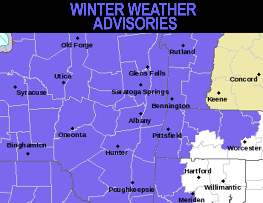
–Winter Weather Advisories are up
–Clouds thicken today, with high temps in the 30s
–Northwest wind slackens as high pressure sets up south and north of us
–Temps aloft are cold, so we start as a mix or all snow by early to mid afternoon, becoming steady light snow with moderate bursts tonight into the pre-dawn hours of Wednesday morning
–Lows tonight in the 20s, with highs in the low to mid 30s on Wednesday
–Snow transitions to snow showers early Wednesday morning, then periods of freezing rain in the high terrain and rain in the valley, with some ice accumulations up to tenth of an inch
–By Wednesday night temps will warm above freezing just about everywhere with steady rainfall moving through into early Thursday morning with lows in the 30s
–Thursday should feature only a few showers north of the Pike during the day, with steadier rains possible in northern CT
–Highs Thursday through Saturday are in the mid to upper 40s
–By Thursday night into Friday we all get into a final slug of rainfall
–Friday dries by afternoon, but we’re mostly cloudy through the weekend, with another chance for rain, ice and snow Sunday into Monday, but details are still murky
~~~~~~~~~~~~~~~~~~~~~~
YOUR MORNING DISCUSSION
~~~~~~~~~~~~~~~~~~~~~~
Good morning everybody, the nutshell is going to cover it for this morning, but I will be providing a full update with discussion this afternoon as our snowfall sets into the region.
The bottom line is that light snow or mixed precip starts between 1-3pm today, most likely, and then becomes a steady accumulating light snow overnight into early Wednesday morning.
At that time, milder air aloft will work overhead, but the cold high pressure to our north in Quebec will keep sub-freezing surface air drained down into at least the high terrain parts of our region, leading to a period of freezing rain Wednesday later morning into afternoon, causing slick travel in some areas.
After that, periods of rainfall move throrugh with milder temps, and then I’m watching the Sunday/Monday timeframe for a stronger, juicier southern stream low center that will bring more inclement weather our way.
Stay tuned and have a great day!
>>> BE KIND <<<
“Hello babies. Welcome to Earth. It’s hot in the summer and cold in the winter. It’s round and wet and crowded. On the outside, babies, you’ve got a hundred years here. There’s only one rule that I know of, babies: Goddamn it, you’ve got to be kind.”
–Kurt Vonnegut