
TABLE OF CONTENTS
* Daily Celestials (Sun/Moon Data)
* Weekly Weather Nutshell
* Morning Discussion
* TIP: Scroll below for sections, or read all
~~~~~~~~~~~~~~~~~~~~~~
YOUR DAILY CELESTIALS
~~~~~~~~~~~~~~~~~~~~~~
STAR:
–OUR STAR WILL RISE AT: 7:17am this morning
–OUR STAR WILL SET AT: 4:39pm this evening
–TOTAL DAYLIGHT TIME: 9 hours and 22 minutes
MOON:
–OUR MOON WILL SET AT: 6:03pm this evening
–MOON SET DIRECTION: West-Southwest
–OUR MOON WILL RISE AT: 9:12am tomorrow morning
–MOON RISE DIRECTION: East-Southeast
–MOON PHASE: Waxing Crescent (1.6%)
~~~~~~~~~~~~~~~~~~~~~~
A NOTE FROM OUR SPONSOR
~~~~~~~~~~~~~~~~~~~~~~
Dave Hayes The Weather Nut is Sponsored by Individual Community Members, Patrons, and Tandem Bagel Company… No matter the weather, Tandem Bagel is always there for you at several valley locations to make your mornings brighter! With bagels baked fresh daily (including Gluten-Free options), house-whipped cream cheese, coffee, and tons of lunch options, Tandem is the perfect quick stop for lunch, breakfast, or a coffee and bagel to go. Find them in Easthampton, Northampton, Hadley, Florence, and West Springfield, or use their super-streamlined online ordering tool by visiting their website: https://www.tandembagelco.com
~~~~~~~~~~~~~~~~~~~~~~
YOUR WEEKLY WEATHER NUTSHELL
~~~~~~~~~~~~~~~~~~~~~~
–High pressure builds through the region bringing partly to mostly sunny skies, highs mid 30s to low 40s
–Clouds will build tonight as another strong low pressure system tracks well west of us and into the Great Lakes
–This sends its warm conveyor belt of moisture northeast and into New England overnight
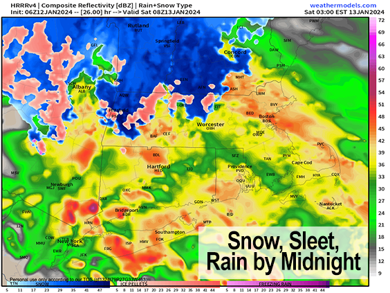
–This will be a quicker hit, with snow, sleet and rain moving through between 11pm and 7am or 8am tomorrow morning
–Snow starts in the Berkshires, western hilltowns, SVT, northern CMass and the eastern Franklin County hilltowns into SWNH
–Generally 1-3″ of snow is possible before changing to sleet and rain, but a 3-6″ stripe is expected in the southern Greens of VT
–Elsewhere any mixed snow goes to or starts as rain, and it will rain hard at times, especially south of Route 2 and along/east of I-91
–Up to 1.5″ of rain should fall, and flooding is expected in some spots
–Southeeast winds will gust 25-40mph overnight, with up to 50-60mph in the Berkshires and southwest VT, isolated outages possible
–Lows will dip to the low to mid 30s then climb briefly into the 40s region-wide, with some low to mid 50s possible in southern MA and northern CT into Saturday morning
–Storm quits by mid-morning with a few rain or snow showers into the night with temps falling back into the 20s
–Sunday looks blustery with gusts out of the west 25-45mph, colder, highs mid 20s to mid 30s with some snow showers expected, lows in the teeens
–Monday morning wind chills may be near or below zero, with highs only getting up into the upper teens to 20s, cold and sunny!
–Tuesday into Wednesday may feature a fluffy snowstorm as cold air will be plentiful, and even colder air dumps into the region into late week with highs in the teens and lows in the single digits
–Another snowstorm is possible to end the week, so stay tuned for updates
~~~~~~~~~~~~~~~~~~~~~~
YOUR MORNING DISCUSSION
~~~~~~~~~~~~~~~~~~~~~~
Good morning everybody, we’ve got our third storm in the 2024 Storm Parade set to swing through the region overnight tonight and be gone by mid morning tomorrow, so this one is a quicker hit and doesn’t impact commutes as much, due to it falling on a weekend and beginning around midnight tonight, well after the Friday evening commute.
You wouldn’t know a storm was coming by the way today is going to play out, as brief high pressure will produce mostly sunny skies and pleasant high temps in the mid 30s to low 40s, with some mid 40s possible in northern CT.
Clouds will increase tonight and a potent low center will track northeast but well west of us, pushing through the Great Lakes and into Canada.
As it swings its cold front well east of its center, a band of heavy precipitation will careen towards New England.
At the same time, a secondary low pressure system will develop along this front, likely staying to the south and east of the WMass region.
This will help to keep cold-enough air locked into far northern MA and up into SVT and SWNH to produce some accumulating wet snow either side of midnight and into the pre-dawn hours, which will mix with and turn to sleet and rain toward the dawn.
This should produce 1-3″ of wet snow in the high terrain of the northern Berkshires, northwest hilltowns, Franklin County and northern CMass into SWNH, with 3-6″ in parts of the southern Greens of VT.
The rest of us generally south of Route 2 will see rain/snow mix changing to heavy rain in the pre-dawn hours, and up to 1.5″ of rain is possible, though many should see less than that before it quits by mid-morning Saturday.
Flood Watches are up, as rivers are still swollen in places and soils are saturated to basement flooding is a real possibility given that the rain will come in a short amount of time, heaviest between 2-6am. Street and stream flooding is also possible.
Lastly, this will pull southeast winds into the area, but again, I think the max winds would be 25-40mph in much of the WMass region as temps will take a while to climb into the 40s, and you need those milder temps at the surface to mix to the ground in these southeasterly setups. Gusts up to 50-60mph are possible in the Berkshires and southwest VT into eastern NY/Taconics overnight.
Temps come up into the 40s and low 50s Saturday morning, precip quits, a few showers or rain are possible in the afternoon changing to snow showers well west of I-91 by Saturday evening and temps will drop into the 20s as colder air works into the region behind the storm.
Sunday looks BLUSTERY in a word, with highs only in the mid 20s to mid 30s with gusty westerlies up to 25-45mph at times throughout the day, which otherwise looks partly sunny with a secondary cold front moving into the region. This will bring some snow showers, and maybe even a snow squall into the evening. Lows will drop to the teens.
Monday / MLK Day is cold and sunny, and breezy, with highs only in the upper teens to 20s!! This will be the coldest day of the new cold season. Lows will plunge into the single digits.
By Tuesday/Wednesday we’re watching continued potential for a powdery, fluffy snowstorm with cold air everywhere, but we need to get through tonight’s storm system and into the weekend to see how it affects the resultant stream flow.
Even colder air comes in for the late week behind that period with highs only in the teens and lows possibly near zero degrees!
Finally, another snowstorm is possible to end the week, so stay tuned as our busy winter weather pattern continues, changes, and strengthens! Have a great day!
>>> BE KIND <<<
“Hello babies. Welcome to Earth. It’s hot in the summer and cold in the winter. It’s round and wet and crowded. On the outside, babies, you’ve got a hundred years here. There’s only one rule that I know of, babies: Goddamn it, you’ve got to be kind.”
–Kurt Vonnegut