
TABLE OF CONTENTS
* Daily Celestials (Sun/Moon Data)
* Weekly Weather Nutshell
* Morning Discussion
* TIP: Scroll below for sections, or read all
~~~~~~~~~~~~~~~~~~~~~~
YOUR DAILY CELESTIALS
~~~~~~~~~~~~~~~~~~~~~~
STAR:
–OUR STAR WILL RISE AT: 7:18am this morning
–OUR STAR WILL SET AT: 4:29pm this evening
–TOTAL DAYLIGHT TIME: 9 hours and 11 minutes
MOON:
–OUR MOON WILL SET AT: 11:03am this morning
–MOON SET DIRECTION: West
–OUR MOON WILL RISE AT: 11:07pm tonight
–MOON RISE DIRECTION: East
–MOON PHASE: Waning Gibbous (65.9%)
~~~~~~~~~~~~~~~~~~~~~~
A NOTE FROM OUR SPONSOR
~~~~~~~~~~~~~~~~~~~~~~
Dave Hayes The Weather Nut is Sponsored by Individual Community Members, Patrons, and Tandem Bagel Company… No matter the weather, Tandem Bagel is always there for you at several valley locations to make your mornings brighter! With bagels baked fresh daily (including Gluten-Free options), house-whipped cream cheese, coffee, and tons of lunch options, Tandem is the perfect quick stop for lunch, breakfast, or a coffee and bagel to go. Find them in Easthampton, Northampton, Hadley, Florence, and West Springfield, or use their super-streamlined online ordering tool by visiting their website.
~~~~~~~~~~~~~~~~~~~~~~
YOUR WEEKLY WEATHER NUTSHELL
~~~~~~~~~~~~~~~~~~~~~~
–We’ve got a cold start to our Tuesday with temps in the teens and 20s
–Mostly sunny skies are expected as upper level ridging replaces a departing upper trough
–Highs reach the mid 30s to low 40s, with light west wind, and lows in the low to mid 20s
–Wednesday looks to be partly sunny overall, but clouds will be building
–Highs will reach to either side of 40º as a northern stream system approaches from the west
–Clouds thicken Wednesday night with lows in the upper 20s
–Thursday is mostly cloudy as this weak system works through, with a few snow or rain showers at times, highs in the upper 30s
–A strong enough cold front pushes through Thursday night, and drops lows into the mid to upper teens
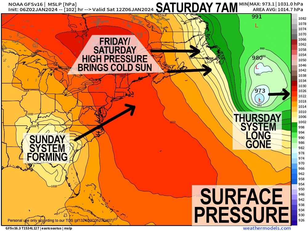
–Friday and Saturday look lovely, but cold, with highs in the upper 20s to mid 30s on Friday, in the 30s for Saturday with partly to mostly sunny skies
–Clouds build late on Saturday, and we have the potential for our first widespread western MA regional snowstorm into Sunday
–If this system “tracks right” we could see the plows coming out, but lots can change between now and then so stay tuned
–More storms loom after Sunday’s system, as we enter into a stormier pattern with all precip types on the table
~~~~~~~~~~~~~~~~~~~~~~
YOUR MORNING DISCUSSION
~~~~~~~~~~~~~~~~~~~~~~
Good morning everybody, we’re starting the day with mostly clear skies, though some clouds are noted around the Berkshires. It’s cold, dry, fog-free, and feeling very January.
Fortunately for us, as we move into the new year, we’ve left that dreary, soupy, foggy, drizzly, showery, crappy weather pattern behind that ended December and 2023, and have entered a sunnier setup with more seasonable temps for the time being.
Once we get to the end of the weekend, it does appear we’ll be entering a more stormy pattern, so things could be getting busier in the weather department with all precip types possible, so I expect that my eardrums will likely be resounding with more peckity-pecks, tappity taps and clickity-clicks in the days and nights ahead.
After today’s cold start, mostly sunny skies are expected for most of us with highs in the mid 30s to low 40s with lows dropping into the low to mid 20s as clouds increase, especially in northern MA up into VT and NH as a weak wave zips east through northern New England.
For Wednesday, any morning clouds should be decreasing as we move through the day, and high temps will be similar to today, somewhere in the mid/upper 30s to low 40s. Let’s call it a partly sunny day on average, with better chance for sunshine in the afternoon.
Clouds will fill back in, however, on Wednesday night into Thursday morning as our northern stream system (that will not marry and live happily ever after with its southern stream partner) tracks east into our region, bringing a few snow or rain showers during the day, with highs in the upper 30s.
A cold front swings through the region Thursday night, and will advect colder Canadian air into the WMass region out of the northwest which will drop our lows into the mid to upper teens.
This will set us up for new high pressure to work into the region from the west and northwest, which will bring colder temps and sunnier skies both Friday and much of Saturday.
Highs Friday will reach the upper 20s to mid 30s with highs in the low to mid 30s or so on Saturday. Lows will drop to the teens and 20s.
By Saturday evening, a storm is likely to track from the southern U.S. with Gulf of Mexico moisture to somewhere along the Mid-Atlantic coastline.
Depending on where the storm exits that part of the eastern seaboard will help determine how much snow we could see here in the WMass region.
At the moment, there isn’t much to support an inside runner and a change from snow to rain.
If anything, the storm could track out to sea to our south and be a miss to a light event here.
Regardless, the potential still exists for a moderately-sized, plowable snowfall along the order of a 4-8″ type system, and while that is no blockbuster, it’s enough to cause significant impacts, so please stay tuned for updates as we get closer.
Beyond that system, we are entering a stormier pattern that could produce any type of storm, from snowy nor’easters, to snow to rain inside runners, to icing events, so now that we’ve entered 2024, we’re becoming more active in the weather department.
I will be here every step of and storm in the way for you, so keep the eyes on this page, and have a great day!
>>> BE KIND <<<
“Hello babies. Welcome to Earth. It’s hot in the summer and cold in the winter. It’s round and wet and crowded. On the outside, babies, you’ve got a hundred years here. There’s only one rule that I know of, babies: Goddamn it, you’ve got to be kind.”
–Kurt Vonnegut