
TABLE OF CONTENTS
* Daily Celestials (Sun/Moon Data)
* Weekly Weather Nutshell
* Morning Discussion
* TIP: Scroll below for sections, or read all
~~~~~~~~~~~~~~~~~~~~~~
YOUR DAILY CELESTIALS
~~~~~~~~~~~~~~~~~~~~~~
STAR:
–OUR STAR ROSE AT: 7:18am this morning
–OUR STAR WILL SET AT: 4:28pm this evening
–TOTAL DAYLIGHT TIME: 9 hours and 10 minutes
MOON:
–OUR MOON WILL RISE AT: 9:05pm tonight
–MOON RISE DIRECTION: East-Northeast
–OUR MOON WILL SET AT: 10:45am tomorrow morning
–MOON SET DIRECTION: West-Northwest
–MOON PHASE: Waning Gibbous (81.5%)
~~~~~~~~~~~~~~~~~~~~~~
>>> A NOTE FROM OUR SPONSOR <<<
Dave Hayes The Weather Nut is Sponsored by Individual Community Members, Patrons, and Gerard, Ghazey & Bates, P.C. GGBPC is a Northampton-based law firm regarded as the voice of pragmatic and well-reasoned estate planning, elder law and tax guidance in Western Massachusetts. The firm specializes in estate planning law, and expertly handles other matters such as Elder Law, Tax Law, as well as Real Estate purchase, sales, and refinance transactions. Contact GGBPC today to see how they can help!
~~~~~~~~~~~~~~~~~~~~~~
YOUR WEEKLY WEATHER NUTSHELL
~~~~~~~~~~~~~~~~~~~~~~
–Low clouds will linger for some of us today, partly sunny day on average, but dry
–High temps reach the mid 30s to low 40s with a light west wind
–Clouds increase overnight, thicker south, thinner north
–Temps around the low to mid 30s for midnight as we cross into 2024, with lows in the mid to upper 20s
–New Year’s Day looks partly sunny south of the Pike with morning clouds, and partly to mostly sunny north of the Pike as clouds thin sooner there as a seaward system scoots south
–Highs in the 30s for the first day of 2024, lows in the low 20s
–Tuesday and Wednesday look like fair weather to me with mostly sunny skies and highs in the mid 30s to low 40s and lows in the mid 20s, dry
–Thursday should cloud up with a northern system tracking east through our region, which will provide some rain and snow showers
–Highs will be in the mid to upper 30s with lows in the 20s
–Another cold front swings through and drops our temps into the low to mid 30s for highs Friday and Saturday
–This will set the stage for a potential winter storm next Sunday, which could be a southern stream system with plenty of moisture, so while it is not anywhere close to a lock a week out, please stay tuned for updates
~~~~~~~~~~~~~~~~~~~~~~
YOUR MORNING DISCUSSION
~~~~~~~~~~~~~~~~~~~~~~
Good morning everybody, I want to start off by saying that 15 years ago I woke up from one of the worst hangovers in my life, and as it turns out, it was the last hangover of my life.
On December 31, 2008 I finally put down alcohol and cigarettes simultaneously, and am so grateful I did. Thanks to you all, you’ve helped me in this effort by giving me a reason to keep showing up over the past 12.5 years of that 15 year period, so thank you for your readership and especially to those who have offered their financial support over the years to keep me dutifully on this task.
As for our weather, we’ve got more clouds around today than it appeared we’d be dealing with yesterday, but they should thin in spots and break up at times, so a partly sunny day on average is more likely than not, with more sunshine by mid-day afternoon, before clouds thicken up again overnight (especially to our south).
Winds will be light out of the west, and highs will reach the mid 30s to low 40s.
All New Year’s Eve plans are a go with dry conditions, and temps around the low to mid 30s tonight at midnight when we cross into 2024.
If you are First Nighting in Northampton, I am playing with my band King Radio at 7pm at St. John’s Episcopal Church on Rt. 9 near the Smith College Art Museum, so I hope to see you there right after the fireworks!
Lows will drop to the mid to upper 20s with partly to mostly cloudy skies.
For New Year’s Day, a storm will be tracking south of our region, but it will spread its northern cloud shield into southern MA and CT/RI, so some of us will start off on the cloudy side, with sunshine increasing as the day wears on tomorrow, with the most sunshine in northern MA and SVT/SWNH.
Highs will climb into the 30s with lows in the low 20s on average, with some upper teens in SVT/SWNH.
Tuesday and Wednesday feature high pressure with sunshine and highs in the mid 30s to low 40s and lows in the 20s, with plenty of fair weather – a big change from last week!
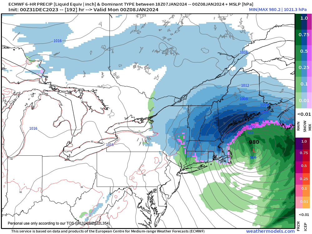
By Thursday, clouds will increase. We’ll have two systems, a colder northern low, and a juicier southern low, but because of an overall zonal streamflow (along with a positive tilt to the upper low center) these two systems will unlikely phase over New England, which means they stay separate until they phase well east of us, dumping snow over Nova Scotia.
For the WMass region, we just get some rain and snow showers from the northern stream system Thursday and Thursday night with highs in the 30s and lows in the 20s.
A cold front swings through, and sets up fair but colder weather for Friday and Saturday with plenty of sunshine and highs only in the low to mid 30s with lows in the low 20s.
I will then be watching a southern stream system that will already be formed and tracking east-northeast toward the east coast.
We would have cold air in place, and it is possible that if this storm continues to trend in our direction, we could have our first region-wide snowstorm in 2024, so stay tuned for updates.
Have a great day, a great night, drive safe, don’t get bombed and drive and be a stupid knucklehead like I used to be, and Happy New Year to all!
>>> BE KIND <<<
“Hello babies. Welcome to Earth. It’s hot in the summer and cold in the winter. It’s round and wet and crowded. On the outside, babies, you’ve got a hundred years here. There’s only one rule that I know of, babies: Goddamn it, you’ve got to be kind.”
–Kurt Vonnegut