
>>> YOUR DAILY CELESTIALS <<<
STAR:
–OUR STAR ROSE AT: 6:59am this morning
–OUR STAR WILL SET AT: 4:19pm this evening
–TOTAL DAYLIGHT TIME: 9 hours and 20 minutes
MOON:
–OUR MOON WILL RISE AT: 11:34pm tonight
–MOON RISE DIRECTION: East-Northeast
–OUR MOON WILL SET AT: 9:11am tomorrow morning
–MOON SET DIRECTION: West-Northwest
–MOON PHASE: Waning Gibbous (74.2%)
~~~~~~~~~~~~~~~~~~~~~~
>>> DAVE’S WEEKLY WEATHER NUTSHELL <<<
–Patchy fog/drizzle this morning, leads to a mostly cloudy day with highs mid 40s to low 50s
–Clouds thicken tonight, lows near 40º
–Scattered showers expected Sunday morning, and some could be heavier
–Heaviest/steadiest rain holds off until afternoon into the night, with wet snow in SVT and SWNH, perhaps mixing into northwest MA (1-4″ of snow in highest peaks), highs 40s
–Everything quits early Monday morning, partial sunshine develops, highs 40s, then temps drop behind a cold front
–Tuesday through Friday is colder with mostly fair conditions and highs in the 30s, lows teens and 20s
–Some lake effect snow showeres possible Tues/Wed
–Accumulating light snow possible with a warm front or Clipper system Friday, but before we get into the details let’s check a note from our local weekend sponsor, #GerardGhazeyBatesPC, an estate planning law firm in Northampton, MA.
~~~~~~~~~~~~~~~~~~~~~~
>>> A NOTE FROM OUR SPONSOR <<<
Dave Hayes The Weather Nut is Sponsored by Individual Community Members, Patrons & Gerard, Ghazey & Bates, P.C. GGBPC is a Northampton-based law firm regarded as the voice of pragmatic and well-reasoned estate planning, elder law and tax guidance in Western Massachusetts. The firm specializes in estate planning law, and expertly handles other matters such as Elder Law, Tax Law, as well as Real Estate purchase, sales, and refinance transactions. Contact GGBPC today to see how they can help!
>>> MORNING DISCUSSION <<<
Good morning everybody, we’ve got a bit of a dreary start out there with patches of fog, drizzle, a few remnant showers, and mostly cloudy skies, but at least it’s fairly mild!
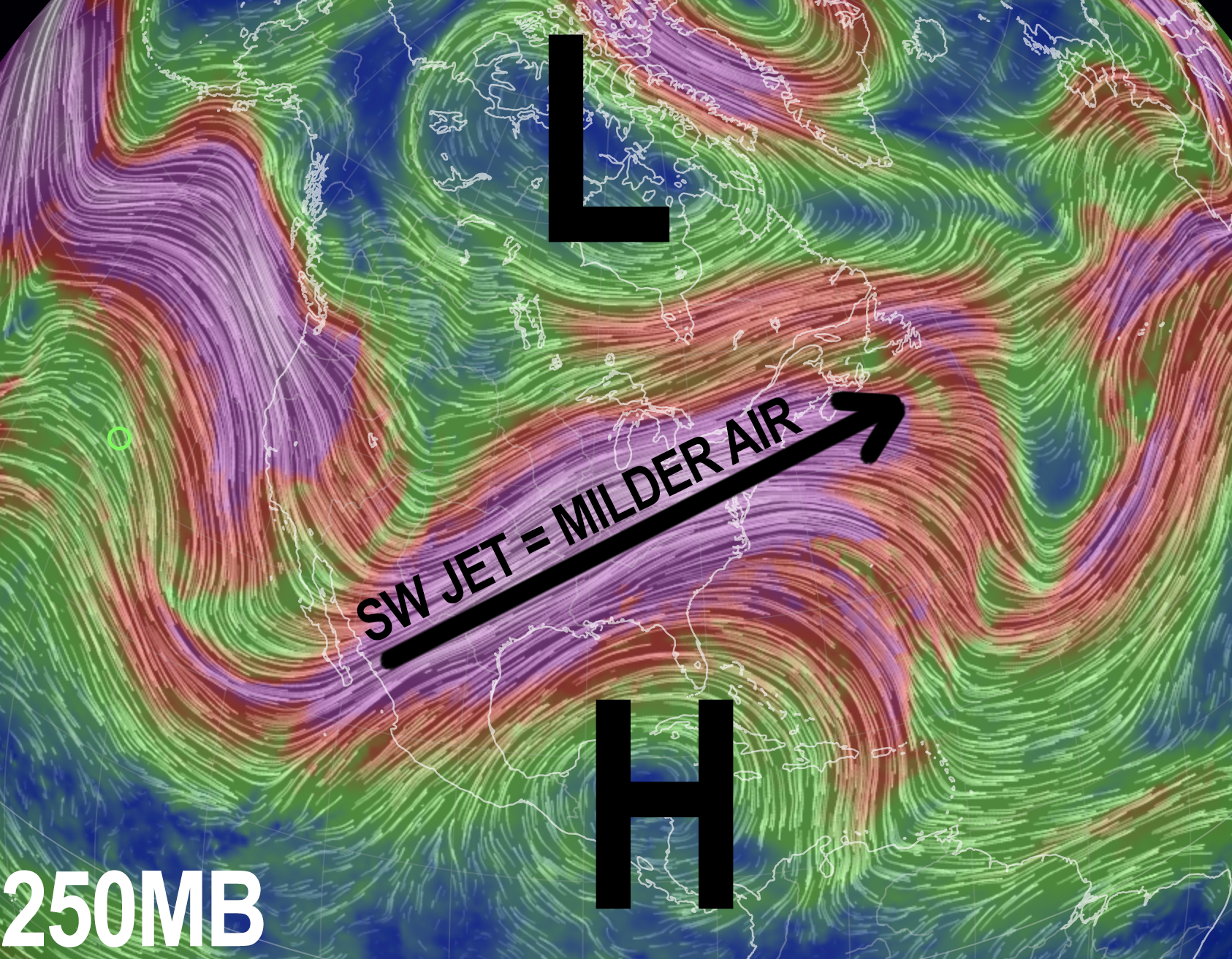
We’ve got a generally southwest flow pushing moisture and mild air into the region, and as such highs will reach the mid 40s to low 50s today, so that will at least be pleasant enough.
We can’t rule out a shower or two, but it should be mostly dry with a few peeks of sunshine possible later this afternoon within the context of this mostly cloudy day.
For tonight, low pressure will be pushing toward western NY and set to arrive on Sunday and Sunday night. This will start streaming moisture and rain showers our way, and lows will dip into the upper 30s to low 40s with patchy fog possible.
By Sunday morning, we should see scattered showers tracking northeast into the greater WMass region, so folks taking part in the Hot Chocolate Run in Northampton tomorrow should don their running rain gear (even though I think the heavier/steadier rain holds off until the afternoon and evening).
Highs Sunday will reach firmly into the 40s, probably mid 40s for most, which isn’t terrible for early December.
As the storm tracks closer Sunday afternoon, a secondary storm will develop south of New England and help enhance moderate (to at times, heavy) rainfall across the region and also help to pull some colder air into the region from the north in conjunction with a Quebec-ian high pressure system, which will initiate a northerly flow.
This will in turn change rain to wet snow in parts of southern VT, southwest NH and perhaps in parts of far northwestern MA in Franklin County and the northern Berkshires.
Peaks above 1500 or 2000 feet could see 1-4″ of wet snow, but as of now, this storm is more of a rain producer.
Lows will drop into the 30s, and precipitation should quit by early Monday morning.
Monday will be the last day to feature 40s for highs through the rest of the upcoming work week as a cold front will swing through the region and drop us back into the 30s for highs Tuesday through Friday as high pressure takes control of our sensible weather. This will also produce lows in the 20s and even teens in the high terrain.
The only fly in the weekly ointment is the potential for a shortwave to run through the northwesterly flow and bring some lake effect or upslope snow showers sometime in the later Tuesday to early Wednesday time frame, so I will update on that piece as we get closer.
Additionally, there is potential for a warm frontal passage on Friday which could produce a period of light accumulating snowfall in the WMass region, so stay tuned for updates on tomorrow’s weather maker, and have a great day!
>>> BE KIND <<<
“Hello babies. Welcome to Earth. It’s hot in the summer and cold in the winter. It’s round and wet and crowded. On the outside, babies, you’ve got a hundred years here. There’s only one rule that I know of, babies: Goddamn it, you’ve got to be kind.”
–Kurt Vonnegut