>>> YOUR DAILY CELESTIALS <<<
STAR:
–OUR STAR ROSE AT: 6:45am this morning
–OUR STAR WILL SET AT: 4:25pm this evening
–TOTAL DAYLIGHT TIME: 9 hours and 40 minutes
MOON:
–OUR MOON WILL SET AT: 10:35pm tonight
–MOON SET DIRECTION: West-Southwest
–OUR MOON WILL RISE AT: 1:10pm tomorrow afternoon
–MOON RISE DIRECTION: East-Southeast
–MOON PHASE: Waxing Crescent (39.9%)
~~~~~~~~~~~~~~~~~~~~~~
>>> DAVE’S WEEKLY WEATHER NUTSHELL <<<
–High pressure builds southeast into our region today, pushiinig a secondary cold front through this afternoon
–We’ll enjoy mostly sunny skies early, with some clouds developing in the afternoon
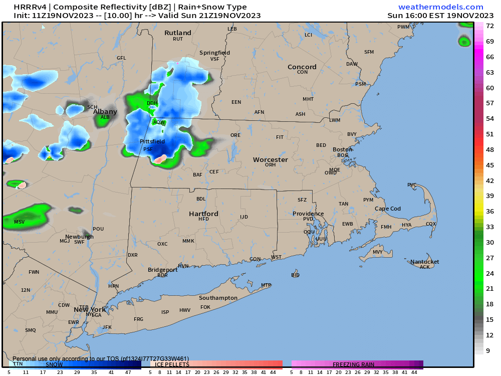
–Some of these clouds could spawn a few scattered rain or snow showers, and our favorite wintry precip type “graupel” may dippin-dot the ground as well
–Highs will reach the upper 30s to upper 30s with lows in the low to mid 20s
–For Monday and Monday night, the coldest 24 hours in our nascent cold season pays us a visit
–Highs will only reach the 30s with lows in the teens under mostly sunny skies, quite cold for this time of year!
–High pressure starts to scoot out of the way to our east by Tuesday, which also looks quite cold with highs in the mid 30s to low 40s as clouds build
–A warm front draped south from a Canadian low center will sweep east into the greater WMass region Tuesday night and spawn a secondary low as it does so
–This second low center should stay south of us, helping to hold in colder air aloft and at the surface
–With precip arriving at the coldest part of the day/night cycle, we should see snow break out across many areas north of the Mass Pike, and rain or rain/snow mix along and south of the Pike by just before midnight
–Accumulating wet snow is looking more likely for SVT, SWNH, the Berkshires, western hilltowns, Franklin County, and northern CMass with up to 1-4″ possible before a change to rain
–South of Greenfield in the Pioneer Valley down into northern CT and southern CMass a coating to an inch is possible, changing to rain Wednesday morning
–Rain will continue into Wednesday afternoon before quitting as our storm is progressive
–Northwest winds will gust Wednesday night into Thanksgiving Day 20-30mph, and Thanksgiving looks cold and dry with highs in the 40s, but before we get into the details let’s check a note from our local weekend sponsor, #GerardGhazeyBatesPC, an estate planning law firm in Northampton, MA.
~~~~~~~~~~~~~~~~~~~~~~
>>> A NOTE FROM OUR SPONSOR <<<
Dave Hayes The Weather Nut is Sponsored by Individual Community Members, Patrons & Gerard, Ghazey & Bates, P.C. GGBPC is a Northampton-based law firm regarded as the voice of pragmatic and well-reasoned estate planning, elder law and tax guidance in Western Massachusetts. The firm specializes in estate planning law, and expertly handles other matters such as Elder Law, Tax Law, as well as Real Estate purchase, sales, and refinance transactions. Contact GGBPC today to see how they can help!
>>> MORNING DISCUSSION <<<
Good morning everybody, aside from a few snow or rain showers possible this afternoon, the main story is the pre-Thanksgiving travel impact of a Tuesday night into Wednesday storm system that continues to strengthen signals around producing wet snow accumulations, especially in the high terrain between 10pm Tuesday to 6am Wednesday.
We cannot rule out 1-4″ of wet snow changing to rain, which would impact some holiday travelers, so I would ask that you stay tuned to updates as we get closer to this event.
It’s not really a major storm, but it will pack a bit of a punch with up to an inch or so of rain possible, and depending on how strong the secondary low gets, and exactly where it deepens in terms of latitude to our south, those considerations will affect any wintry impacts.
Today and tomorrow are pleasant days, but quite cold, and with a secondary cold front moving through this afternoon, a few snow or rain showers are possible with highs in the upper 30s to upper 40s and lows in the 20s.
Monday and Monday night are going to produce mid-winter temperatures with highs only in the 30s and lows in the teens, so bundle up!
Tuesday will cloud up, but should be a final dry day with any rain or snow holding off until just before midnight as Tuesday starts setting sail into Wednesday.
Our snow and rain moves through Tuesday night into Wednesday early afternoon, and then a frontal boundary swings through with gusty northwesterlies up to 30mph later Wednesday into the night as we dry out.
Highs will reach the 40s on Wednesday, but from Thanksgiving Day into Saturday we’ll only see highs in the mid 30s to mid 40s with partly to mostly sunny skies as high pressure works into the region.
Then, another snow to rain storm is possible for Saturday afternoon or night, but that storm looks faster-moving, so it may be less of an impact on our region.
I will be updating you all on Tues/Wed and Saturday storm impacts as we get closer, but at least Thanksgiving Day and Night looks like a pleasant day replete with autumnal feels.
Have a great rest of your weekend!
>>> BE KIND <<<
“Hello babies. Welcome to Earth. It’s hot in the summer and cold in the winter. It’s round and wet and crowded. On the outside, babies, you’ve got a hundred years here. There’s only one rule that I know of, babies: Goddamn it, you’ve got to be kind.”
–Kurt Vonnegut
