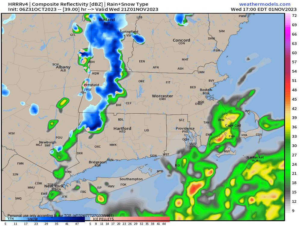
Snow showers tomorrow
TABLE OF CONTENTS
* Daily Celestials (Sun/Moon Data)
* Weekly Weather Nutshell
* Morning Discussion
* TIP: Scroll below for sections, or read all
~~~~~~~~~~~~~~~~~~~~~~
YOUR DAILY CELESTIALS
~~~~~~~~~~~~~~~~~~~~~~
STAR:
–OUR STAR WILL RISE AT: 7:21am this morning
–OUR STAR WILL SET AT: 5:45pm this evening
–TOTAL DAYLIGHT TIME: 10 hours and 24 minutes
MOON:
–OUR MOON WILL RISE AT: 7:27pm this evening
–MOON RISE DIRECTION: East-Northeast
–OUR MOON WILL SET AT: 11:48am tomorrow morning
–MOON SET DIRECTION: Northwest
–MOON PHASE: Waning Gibbous (91.6%)
~~~~~~~~~~~~~~~~~~~~~~
YOUR WEEKLY WEATHER NUTSHELL
~~~~~~~~~~~~~~~~~~~~~~
–Mostly sunny skies and highs in the mid to upper 40s today
–Dry for Halloween but chilly, so bundle all the peeps up given temps either side of 40º during the candy parade
–Patchy frost tonight with lows in the upper 20s to mid 30s as clouds increase
–A storm passes southeast of us tomorrow morning, but may graze far eastern CT and southeast CMass with some rain or snow showers in the early morning, otherwise dry in the WMass region
–Upper level temps plummet tomorrow afternoon as an upper low tracks east into the region
–This will set off scattered snow and rain showers, or mixed showers by late morning into the afternoon
–We cannot rule out potential for some snow coatings in the Berkshires, western hilltowns, SVT and even a few other parts of NW.CT, northern CMass and SWNH
–If everything aligns, we may even see a half inch to an inch of wet snow on grassy surfaces by evening
–Highs Wednesday only reach the upper 30s to mid 40s
–Hard freeze late Wednesday night as the upper low exits the region, with lows in the 20s
–Again, the growing season is over, so get your tender ones inside or protected somehow
–Thursday through Sunday looks lovely with slowly increasing temps thanks to high pressure building into the Mid-Atlantic region to our south
–Highs will be in the 40s Thursday, 50s Friday and Saturday, and either side of 60º by Sunday with partly to mostly sunny skies throughout
–A strong storm signal continues to show up for next Tuesday, and we can’t rule out wintry weather in the high terrain so stay tuned, but before we talk details let’s check a note from our local and delicious sponsor, #TandemBagelCo, with their newest location in the Stop & Shop Plaza on King Street in Northampton, MA.
~~~~~~~~~~~~~~~~~~~~~~
A NOTE FROM OUR SPONSOR
~~~~~~~~~~~~~~~~~~~~~~
Dave Hayes The Weather Nut is Sponsored by Individual Community Members, Patrons, and Tandem Bagel Company… No matter the weather, Tandem Bagel is always there for you at several valley locations to make your mornings brighter! With bagels baked fresh daily (including Gluten-Free options), house-whipped cream cheese, coffee, and tons of lunch options, Tandem is the perfect quick stop for lunch, breakfast, or a coffee and bagel to go. Find them in Easthampton, Northampton, Hadley, Florence, and West Springfield, or use their super-streamlined online ordering tool by visiting their website.
~~~~~~~~~~~~~~~~~~~~~~
YOUR MORNING DISCUSSION
~~~~~~~~~~~~~~~~~~~~~~
Good morning everybody, we received anywhere from half an inch up to an inch and a half or so of rainfall over the past two days, but those conditions are in the rear view mirror now, and we’re left with remnant chill, and now a potential for some of us to see our first snowflakes of the incoming cold season tomorrow as we turn from October to November.
We have patchy frost this morning, and we’ll have more tonight, and then a hard freeze by late Wednesday night into early Thursday morning so protect thy plants! Highs will only reach the mid to upper 40s today under mostly sunny skies.
For Halloween this evening it will be dry but cold, with temps either side of 40º, and probably more like the mid to upper 30s in the high terrain areas if you are out later after sunset.
For Wednesday, a coastal storm is suppressed southeast but may bring a few rain or snow showers to southeast CMass or far eastern CT, but even those areas likely stay dry like the rest of us.
We’ll just see some clouds for the early to mid morning especially east of the I-91 corridor.
Then we watch to the west as an upper low comes in with a DEEP pool of very cold air.
This should set up steep lapse rates encourging rising air, albeit rising into a less humid atmosphere.
Still, we should see scattered snow and rain showers break out by late morning into the afternoon tomorrow, and we can’t rule out a coating to as much as an inch of wet snow on grassy surfaces in the high terrain, which just “air snow” mixed into valley locations, if at all.
Highs will be the coldest yet, only in the upper 30s to mid 40s. Behind the upper level low, temps CRASH into the 20s with a hard freeze expected tomorrow night.
Then we watch high pressure build east-northeast out of the southern U.S. toward the Mid-Atlantic coastline, which will foster hopefully 4 days of partial to full sunshine and increasing temps from the 40s Thursday, to the 50s Friday and Saturday, to the low 60s for some on Sunday.
Thereafter, we’ve got a frontal boundary passage by early next week followed by a potentially potent storm system that may bring rain and/or snow-ice to the region by next Tuesday or Wednesday, so stay tuned and have a great day!
>>> BE KIND <<<
“Hello babies. Welcome to Earth. It’s hot in the summer and cold in the winter. It’s round and wet and crowded. On the outside, babies, you’ve got a hundred years here. There’s only one rule that I know of, babies: Goddamn it, you’ve got to be kind.”
–Kurt Vonnegut
