>>> YOUR DAILY CELESTIALS <<<
STAR:
–OUR STAR ROSE AT: 7:09am this morning
–OUR STAR WILL SET AT: 5:59pm this evening
–TOTAL DAYLIGHT TIME: 10 hours and 50 minutes
MOON:
–OUR MOON WILL SET AT: 11:11pm tonight
–MOON SET DIRECTION: Southwest
–OUR MOON WILL RISE AT: 3:05pm tomorrow afternoon
–MOON RISE DIRECTION: East-Southeast
–MOON PHASE: Waxing Crescent (42.7%)
~~~~~~~~~~~~~~~~~~~~~~
>>> DAVE’S WEEKLY WEATHER NUTSHELL <<<
–Temps are very mild in the 50s to low 60s this morning
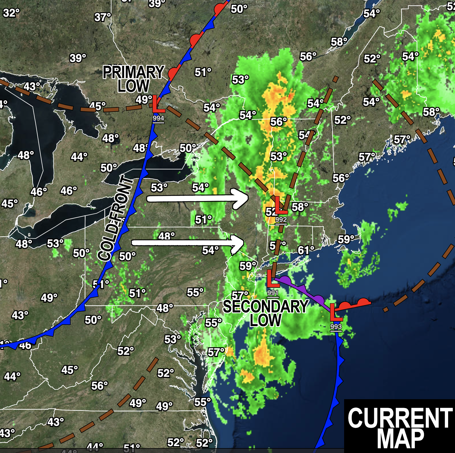
–Heavy rain in the Berkshires and western hilltowns early this morning, drier from the valley east for now
–Secondary surface low pressure south of Long Island strengthens and spreads rain back into the region by mid-day
–Rain with some thunder sweeps northeast and abates by around sunset to 9-10pm from southwest to northeast (earlier in the Berkshires, later in eastern CMass)
–West winds kick up and gust 25-45mph starting around later afternoon through tonight and into Sunday
–Lows tonight drop to the mid to upper 40s as a breezy night arrives, isolated outages possible
–Sunday is much cooler, highs 40s to 50s, west winds gust 20-40mph, partly sunny to mostly cloudy, lows either side of 40º
–Monday becomes mostly sunny as high pressure works in, highs mid to upper 50s
–Frost possible for Monday night into Tuesday morning with lows low to mid 30s, prepare #PlantPeople
–Tuesday through Thursday looks lovely, highs increasing into the 60s, and maybe even low 70s for a day with sunshine!
–By late next week, a storm will be tracking north of us and may swing a cold front through with more showers Friday into Saturday and cooler temps into next weekend, but before we get into the details let’s check a note from our local weekend sponsor, #GerardGhazeyBatesPC, an estate planning law firm in Northampton, MA.
~~~~~~~~~~~~~~~~~~~~~~
>>> A NOTE FROM OUR SPONSOR <<<
Dave Hayes The Weather Nut is Sponsored by Individual Community Members, Patrons & Gerard, Ghazey & Bates, P.C. GGBPC is a Northampton-based law firm regarded as the voice of pragmatic and well-reasoned estate planning, elder law and tax guidance in Western Massachusetts. The firm specializes in estate planning law, and expertly handles other matters such as Elder Law, Tax Law, as well as Real Estate purchase, sales, and refinance transactions. Contact GGBPC today to see how they can help!
>>> MORNING DISCUSSION <<<
Good morning everybody, we’re getting started in the clouds and for folks west of the CT River, in the rain, which has been falling heavy at times with some areas approaching 2.5″ of rain in the Berkshires already!
East of the river we are in the morning lull I alluded to yesterday, but I do not suspect that will last much past the noon hour.
As it stands now, our secondary coastal low has formed and is developing steadily, and should deepen to a sub-990mb low center by mid-day as it tracks south of Long Island, moving east-northeast toward southeast MA.
As it does so, our negatively-tilted upper level trough will continue to help it strengthen which should produce a wider rain shield through the greater WMass region this afternoon and early evening before rain abates between 6-10pm from west to east.
As the drier air works in from the southwest during this process in accordance with our storm tracking away from the region as it heads to Nova Scotia, westerly winds will kick up later this afternoon and tonight, gusting 25-45mph at times.
Where soils are very wet from heavier rains, and from a wet summer, we may see some trees topple which could produce some isolated outages, especially iin the high terrain of W.MA and S.VT.
Lows drop to the mid to upper 40s tonight, and winds will continue to gust 20-40mph tomorrow and then slacken after noon at some point as the pressure gradient eases into the night.
Highs tomorrow will only reach the upper 40s to mid 50s under mostly cloudy skies, but some sunny breaks are possible. Lows will drop to either side of 40º and we can’t rule out some isolated showers tomorrow, either.
Monday should brigthen into a partly to mostly sunny day with highs in the mid to upper 50s with light wind.
As we clear and wind quits, radiational cooling will take place Monday night with lows dropping into the low to mid 30s, with patchy to possibly widespread frost, so you have been re-alerted.
Tuesday through Thursday puts us into full-on high pressure mode with the high center passing south of us, which means a warming southwest flow will develop through the week.
Not only can we expect sunny skies and fair weather, but highs should push well into the 60s, and possibly even into the low 70s for some of us in the CT River Valley!
It won’t last long, though, as a cold front attached to a deepening storm that will track well north of us on Friday and Saturday brings more clouds, some showers, and colder temps into next weekend. Friday should be more or less salvaged, however, but what we really want is a nice weekend for cripes sakes, as my Nana would say! CRIPES!!
Have a great day and don’t throw rotten tomatoes at me! Wait! Please do, as I will make delicious sauce out of them!!
>>> BE KIND <<<
“Hello babies. Welcome to Earth. It’s hot in the summer and cold in the winter. It’s round and wet and crowded. On the outside, babies, you’ve got a hundred years here. There’s only one rule that I know of, babies: Goddamn it, you’ve got to be kind.”
–Kurt Vonnegut
