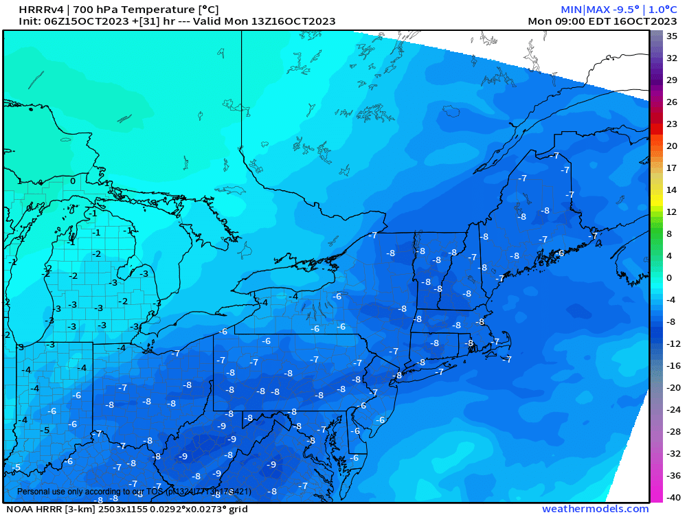
Cold temps aloft produce graupel tomorrow? Possible!
>>> YOUR DAILY CELESTIALS <<<
STAR:
–OUR STAR ROSE AT: 7:02am this morning
–OUR STAR WILL SET AT: 6:08pm this evening
–TOTAL DAYLIGHT TIME: 11 hours and 6 minutes
MOON:
–OUR MOON WILL SET AT: 6:32pm this evening
–MOON SET DIRECTION: West-Southwest
–OUR MOON WILL RISE AT: 9:00am tomorrow morning
–MOON RISE DIRECTION: East-Southeast
–MOON PHASE: Waxing Crescent (0.5%)
~~~~~~~~~~~~~~~~~~~~~~
>>> DAVE’S WEEKLY WEATHER NUTSHELL <<<
–Partly sunny today as a powerful ocean storm pulls away
–Patchy fog burns off, highs reach the 50s, NW winds gust to 20mph at times
–Clouds build a bit tonight, lows drop into the low to mid 40s
–Scattered showers are expected tomorrow as a wave drops from north to south through the region
–Very cold mid-level temps well below freezing may help to allow some graupel to fall to the ground (i.e. ice-encased snowflakes, or soft hail)
–Highs Monday and Tuesday will be in the 50s to low 60s, with lows in the low 40s, with a spot shower also possible Tuesday
–High pressure sweeps in from the southwest mid to late week bringing more sunshine and milder temps with highs in the 60s
–A potent low may form closer to the coast this time, and bring a windswept rainfall for some of us, especially eastern CT and CMass
–Cooler air comes in behind that departing low by Sunday, and we can’t rule out the first snowflakes of the incoming cold season for the Berkshires or SVT, but before we get into the details let’s check a note from our local weekend sponsor, #GerardGhazeyBatesPC, an estate planning law firm in Northampton, MA.
~~~~~~~~~~~~~~~~~~~~~~
>>> A NOTE FROM OUR SPONSOR <<<
Dave Hayes The Weather Nut is Sponsored by Individual Community Members, Patrons & Gerard, Ghazey & Bates, P.C. GGBPC is a Northampton-based law firm regarded as the voice of pragmatic and well-reasoned estate planning, elder law and tax guidance in Western Massachusetts. The firm specializes in estate planning law, and expertly handles other matters such as Elder Law, Tax Law, as well as Real Estate purchase, sales, and refinance transactions. Contact GGBPC today to see how they can help!
>>> MORNING DISCUSSION <<<
Good morning everybody, our coastal storm that was a near miss to the south yesterday has blown up into a 982mb powerful ocean storm, with an impressive comma-shape formation out over the Atlantic this morning.
Fortunately, we just have some gorgeous mid-level “fish fillet” clouds overhead this morning, that also looks a sandy beach after some wave action produced ripples in the sand.
Waves above
Waves below
Everything is waves
Don’t ya know?
Everything we see, feel, hear and sense is made of vibrations, and it’s cool to perceive them in nature.
Anyway, we have a peaceful but breezy-at-times day ahead with partly sunny skies, and northwest gusts to 20mph as a decent pressure gradient passes through the region.
Stratocumulus cloud decks should develop later (I like to call them “pancake clouds”) and highs should reach the 50s to near 60º, with lows in the low to mid 40s as clouds increase in response to an incoming shortwave dropping south into our region out of northern New England and southeast Canada.
I think we will see some scattered showers Monday, and as early as the morning, but a shower could move through any time on Monday.
Highs will reach the 50s (upper 50s in the valley) and lows will again be in the low 40s.
Tuesday should be the last day under the influence of an upper low over nearby Atlantic Canada (the same upper low that will spawn Monday’s shortwave), so I expect more clouds than sun with highs again in the 55-60º range.
Strong and sprawling high pressure will sweep across the southern two-thirds of the country and pass to our south through the mid to late week period.
This will produce mostly sunny skies, with milder highs in the upper 50s to mid 60s, so I expect a very nice back half of the upcoming work week!
Thereafter, however, still holds the potential for a strong coastal storm that could bring rain and wind into the greater WMass region for Saturday, possibly lasting into early Sunday.
Not only that, but by Sunday night, the incoming colder air behind that system may help induce the first snowflakes across the high terrain in the Berkshires and southern VT and Taconics of eastern NY with a potential for a more widespread frost into that early Monday morning (about 8 days from now), so stay tuned for updates, and hopefully that storm stays south like this one did!!
Have a great day!
>>> BE KIND <<<
“Hello babies. Welcome to Earth. It’s hot in the summer and cold in the winter. It’s round and wet and crowded. On the outside, babies, you’ve got a hundred years here. There’s only one rule that I know of, babies: Goddamn it, you’ve got to be kind.”
–Kurt Vonnegut
