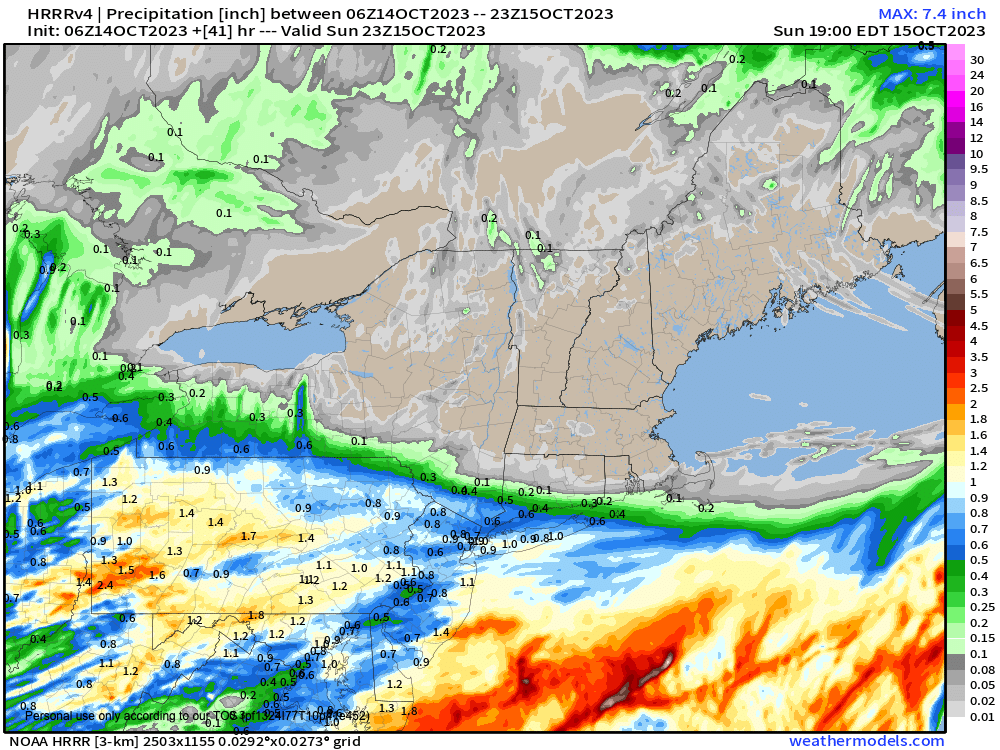
Rain likely stays south into CT
>>> YOUR DAILY CELESTIALS <<<
STAR:
–OUR STAR ROSE AT: 7:01am this morning
–OUR STAR WILL SET AT: 6:10pm this evening
–TOTAL DAYLIGHT TIME: 11 hours and 9 minutes
MOON:
–OUR MOON WILL SET AT: 6:10pm this evening
–MOON SET DIRECTION: West-Southwest
–OUR MOON WILL RISE AT: 7:53am tomorrow morning
–MOON RISE DIRECTION: East-Southeast
–MOON PHASE: ***NEW MOON***
~~~~~~~~~~~~~~~~~~~~~~
>>> DAVE’S WEEKLY WEATHER NUTSHELL <<<
–Patchy fog burns off this morning with partly sunny skies north, and increasing clouds south
–Highs in the 50s with mostly cloudy skies tonight and some light rain showers in northern CT
–Very low chance of showers dotting parts of southern WMass and CMass this evening, otherwise dry
–Lows drop into the low to mid 40s
–Partly to mostly sunny skies develop after morning clouds south of the Pike, with highs 55-60º
–Lows drop into the low to mid 40s under partly cloudy skies
–Monday and Tuesday will feature a couple of weak waves combining with cold air aloft to produce some isolated to scattered showers each day, but no washout
–Highs again will only reach the 55-60º range, with lows in the 40s
–Mid to late week features high pressure finally pushing upper low pressure east and out to sea
–This brings more sunshine and milder highs well into the 60s
–However, signals continue for a dynamic, potentially rainy and windy nor’easter next weekend, but before we get into the details let’s check a note from our local weekend sponsor, #GerardGhazeyBatesPC, an estate planning law firm in Northampton, MA.
~~~~~~~~~~~~~~~~~~~~~~
>>> A NOTE FROM OUR SPONSOR <<<
Dave Hayes The Weather Nut is Sponsored by Individual Community Members, Patrons & Gerard, Ghazey & Bates, P.C. GGBPC is a Northampton-based law firm regarded as the voice of pragmatic and well-reasoned estate planning, elder law and tax guidance in Western Massachusetts. The firm specializes in estate planning law, and expertly handles other matters such as Elder Law, Tax Law, as well as Real Estate purchase, sales, and refinance transactions. Contact GGBPC today to see how they can help!
>>> MORNING DISCUSSION <<<
Good morning everybody, I hope you slept well, I hope this day goes well for you, I hope you find some solace in it somehow, I hope you have a good meal today, and I hope you are able to find connection within yourself or with others as well.
As far as our weather is concerned, it’s falling squarely into the #NoBigWhoop zone, with plenty of dry air pushing in from the north.
This is going to help shunt our secondary coastal low pressure system south, developing it along the Virginia coastline and causing it to track just north of due east, which should help ensure that any scattered showers come no further north than northern CT later this afternoon and this evening, with a spot shower possible earlier.
Could a few showers make it north of the MA/CT state line? Yes, but it’s a VERY low chance, and I’m not expecting that to occur.
Highs reach the mid to upper 50s in a cool/light northwesterly flow with clouds increasing later today, with more of a partly sunny day in northern MA up into SVT/SWNH. Lows tonight drop into the low to mid 40s with mostly cloudy skies expected.
The storm pulls away tomorrow to the east, and any morning clouds dissipate to a partly to mostly sunny day with highs in the 55-60º range, which lasts through at least Tuesday (lows Sunday night will be in the 40s).
Monday and Tuesday look to be dominated by a nearby trough to our northeast that combines with moisture to our south to send a couple weak waves through our region with some scattered showers possible each day, but again, this doesn’t look “wash-out-y” at all. Still, mostly cloudy skies are expected.
By mid-week, high pressure builds into the region along with an upper ridge that will foster sunnier skies and milder temps with highs in the 60s — a very nice-looking stretch!
It’s a long way off, but this fair weather period may end up preceding a potentially stormy weekend.
A more dynamic signal for a rainy and windy nor’easter continues to show on guidance, with cold polar air meeting up with juicy mild air from the south in the form of a “Miller A” type coastal storm that tracks more southwest to northeast toward Cape Cod.
If I saw this set up in the winter my neck hairs would be standing on end for a major snowstorm, but as it stands now, it’s just a signal 7 days out, and could change in the coming days.
Still, it’s enough for me to say “stay tuned” in the coming days, because it could be a windy soaker, and given our streak of wet weekends, I would say to you enjoy this one as much as possible, folks!
Have a great day!
>>> BE KIND <<<
“Hello babies. Welcome to Earth. It’s hot in the summer and cold in the winter. It’s round and wet and crowded. On the outside, babies, you’ve got a hundred years here. There’s only one rule that I know of, babies: Goddamn it, you’ve got to be kind.”
–Kurt Vonnegut
