>>> YOUR DAILY CELESTIALS <<<
STAR:
–OUR STAR ROSE AT: 6:44am this morning
–OUR STAR WILL SET AT: 6:35pm this evening
–TOTAL DAYLIGHT TIME: 11 hours and 51 minutes
MOON:
–OUR MOON WILL RISE AT: 6:53pm this evening
–MOON RISE DIRECTION: East
–OUR MOON WILL SET AT: 8:05am tomorrow morning
–MOON SET DIRECTION: West
–MOON PHASE: Waning Gibbous (99.9%)
~~~~~~~~~~~~~~~~~~~~~~
>>> DAVE’S WEEKLY WEATHER NUTSHELL <<<
–Rain, heavy at times, will slow the morning commute for some, especially near and south of the Pike, including the Pike
–Heaviest rainfall is likely relegated to southwest MA in a line from Springfield westward to Pittsfield on south into Hartford and Litchfield Counties CT
–Rain showers will fall in varying intensity today in the rest of WMass, SVT, SWNH and northeast CT into CMass, sometimes heavy
–Highs will be chilly, in the 50s to low 60s, and dipping to either side of 50º with patchy fog overnight with less showers
–Rain will be pulling south and east by Saturday morning with one final pulse in southern MA and northern CT before we start to dry by afternoon
–Sunday is the pick of the weekend, a gorgeous weekend day on tap with highs into the mid 70s!
–Monday through Thursday are dominated by high pressure and fair weather, with highs well into the 70s and lows in the 50s
–A frontal passage may bring showers and storms Friday, but before we talk details let’s check a note from our local and delicious sponsor, #TandemBagelCo, with their newest location in the Stop & Shop Plaza on King Street in Northampton, MA.
~~~~~~~~~~~~~~~~~~~~~~
>>> A NOTE FROM OUR SPONSOR <<<
Dave Hayes The Weather Nut is Sponsored by Individual Community Members, Patrons & Tandem Bagel Company… No matter the weather, Tandem Bagel is always there for you at several valley locations to make your mornings brighter! With bagels baked fresh daily (including Gluten-Free options), house-whipped cream cheese, coffee, and tons of lunch options, Tandem is the perfect quick stop for lunch, breakfast, or a coffee and bagel to go. Find them in Easthampton, Northampton, Hadley, Florence, and West Springfield, or use their super-streamlined online ordering tool by visiting their website.
>>> MORNING DISCUSSION <<<
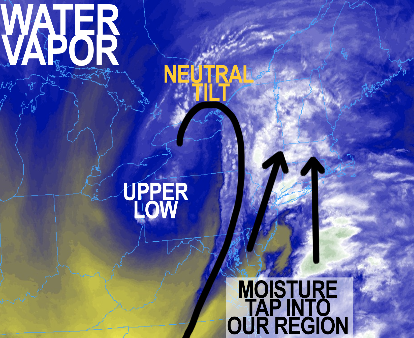
Good morning everybody, rain which will fall heavily at times, is tracking south to north into our region this morning, and has arrived in many areas already.
We’ve got an upper low over western PA/NY, the axis of which is tilting neutrally to negatively (going from N/W to NW/SE), which is sweeping copious moisture to our south up and into the greater WMass this region.
This is being run into and over some local atmospheric boundaries / fronts, causing air to lift skyward, condense and produce our rainfall.
Based on the radar trends I am watching this morning, while we’re looking at heaviest rain likely over southwest MA and western CT where Flood Watches are up (and 1-4″ of rain is likely), that heavier rain total could shift north and east into more of WMass and north-central CT.
All this to say, the potential exists for localized street/flash flooding in all of WMass today, though again, the most likely area for such an outcome is western CT down into the NYC metro area.
It will be chilly today with highs only in the mid 50s to low 60s with overcast skies, and showers this morning lasting through the afternoon at varying rates of intensity, with a lessening of activity late tonight as the surface low pulls east and starts to pull away from our longitude. Lows will drop to either side of 50º with patchy fog possible.
We can’t rule out a final pulse of rain showers along and south of the Pike in MA, CT and RI tomorrow morning before we start to dry things out during the afternoon.
Highs should be milder, reaching the low to mid 60s, and we may even get some sunny breaks late in the day as the storm pulls away. Lows will fall into the low to mid 50s.
Sunday is definitely looking like the weekend pick as high pressure builds southeast out of Canada and into New England.
Mostly sunny skies look to last for as much as 5 consecutive days, Sunday through Thursday, with highs in the low to mid 70s and lows in the 50s, with potential for upper 70s late in the week.
Another strong storm looks to track east across southern Canada and drag its attendant cold front through our region on Friday which would bring more showers and thunderstorms by the very end of the week into the first part of next weekend, with cooler temps moving in behind that frontal passage.
I hope things go your way today, I hope you are able to genuinely smile about something today, and I hope that you feel loved wherever you are and with whomever you’re with, even if you’re by yourself.
Have a great day!
>>> BE KIND <<<
“Hello babies. Welcome to Earth. It’s hot in the summer and cold in the winter. It’s round and wet and crowded. On the outside, babies, you’ve got a hundred years here. There’s only one rule that I know of, babies: Goddamn it, you’ve got to be kind.”
–Kurt Vonnegut
