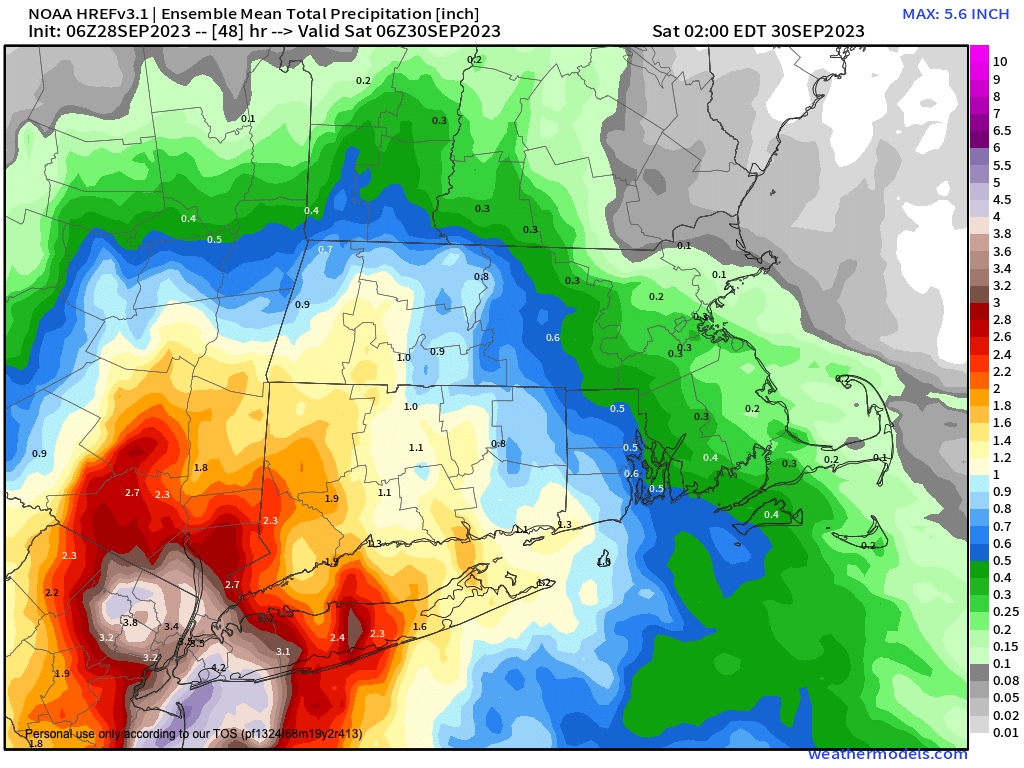
Friday PM into Sat. AM rainy
>>> YOUR DAILY CELESTIALS <<<
STAR:
–OUR STAR ROSE AT: 6:43am this morning
–OUR STAR WILL SET AT: 6:37pm this evening
–TOTAL DAYLIGHT TIME: 11 hours and 54 minutes
MOON:
–OUR MOON WILL RISE AT: 6:30pm this eveniing
–MOON RISE DIRECTION: East
–OUR MOON WILL SET AT: 6:48am tomorrow morning
–MOON SET DIRECTION: West
–MOON PHASE: Full Harvest Moon
~~~~~~~~~~~~~~~~~~~~~~
>>> DAVE’S WEEKLY WEATHER NUTSHELL <<<
–Patchy dense fog will burn off later this morning
–Waning influence of high pressure brings mostly sunny skies with some haze
–Highs reach the 60s (low to mid in the high terrain, mid to upper in the valley)
–Clouds build tonight, lows in the mid to upper 40s
–A few isolated showers are possible in the morning, wiht highs Friday reaching the upper 50s to low 60s
–Depending on how close the storm makes it north, showers may become more widespread by Friday afternoon and certainly by evening with lows in the 40s
–Friday night into Saturday looks rainy south of the Route 2 corridor in MA and CT, but this is subject to change
–Any showers should start to taper sometime Saturday afternoon with highs in the low to mid 60s with cloudy skies expected, and lows in the upper 40s to low 50s
–Behind this storm, we flip the switch to warmer temps, with partly sunny skies for Sunday and highs in the upper 60s to mid 70s
–Monday through Thursday look seasonably warm with highs in the low to mid 70s before another frontal boundary brings showers very late week or by the start of the following weekend, but before we talk details let’s check a note from our local and delicious sponsor, #TandemBagelCo, with their newest location in the Stop & Shop Plaza on King Street in Northampton, MA.
~~~~~~~~~~~~~~~~~~~~~~
>>> A NOTE FROM OUR SPONSOR <<<
Dave Hayes The Weather Nut is Sponsored by Individual Community Members, Patrons & Tandem Bagel Company… No matter the weather, Tandem Bagel is always there for you at several valley locations to make your mornings brighter! With bagels baked fresh daily (including Gluten-Free options), house-whipped cream cheese, coffee, and tons of lunch options, Tandem is the perfect quick stop for lunch, breakfast, or a coffee and bagel to go. Find them in Easthampton, Northampton, Hadley, Florence, and West Springfield, or use their super-streamlined online ordering tool by visiting their website.
>>> MORNING DISCUSSION <<<
Good morning everybody, we’ve got quite a bit of fog this morning, and some of it is quite dense with visibilities down to a quarter mile or less (Worcester, Orange, North Adams MA, Willimantic CT and other areas, too).
This should all burn off by mid to later morning, and reveal a mostly sunny, albeit hazy sky day with highs in the 60s.
All this to say, take it easy on the roads this morning as visibility will be an issue for some of us.
After the fog burns off, we’ll grow into a mostly sunny days, albeit with hazy skies due to wildfire smoke moving through the region aloft. Highs reach the 60s, and lows will get down into the mid to upper 40s as clouds build into the region.
Low pressure will be tracking east on Friday, associated with an upper level trough swinging into the eeasterrn Great alakes.
As high pressure scoots east, it may get far enough to “make way” or room for the low to come more north, and if that happens, we could be getting soaked by later Friday afternoon, night and into the first part of Saturday.
However, that is not a lock, and for now I’m thinking that areas south of the Pike and mostly northern CT is where heaviest rain will fall Friday afternoon into and through Saturday morning, but will update later this afternoon and again tomorrow morning.
It’s a mostly cloudy day on Friday with high temps either side of 60º (mid to upper 50s in the hilltowns), with a few scattered showers possible in the morning before heavier steadier stuff starts to impinge on the greater WMass region.
Friday night will see lows in the 40s with wet weather expected in WMass, CMass and northern CT, and just a few showers in SVT and SWNH, and this should last into Saturday.
Showers should quit by Saturday afternoon or so with highs in the 60s, and lows near 50º as the storm pulls away.
By Sunday, sunshine breaks out and a warmer flow will work into the region with highs in the upper 60s to mid 70s.
This fair weather dome thanks to renewed high pressure should last into the late week period with highs in the low to mid 70s and possibly upper 70s by Thursday or Friday, and with lows in the 50s with plenty of sunshine.
By next Friday or Saturday, we could see an intense cyclone wrap up in Quebec Province, Canada and track east, which would send a cold front through our region, bringing a period of showers by Saturday, with the potential for thunderstorms as well.
Have a great day!
>>> BE KIND <<<
“Hello babies. Welcome to Earth. It’s hot in the summer and cold in the winter. It’s round and wet and crowded. On the outside, babies, you’ve got a hundred years here. There’s only one rule that I know of, babies: Goddamn it, you’ve got to be kind.”
–Kurt Vonnegut
