>>> YOUR DAILY CELESTIALS <<<
STAR:
–OUR STAR ROSE AT: 6:41am this morning
–OUR STAR WILL SET AT: 6:40pm this evening
–TOTAL DAYLIGHT TIME: 11 hours and 59 minutes
MOON:
–OUR MOON WILL RISE AT: 5:38pm this afternoon
–MOON RISE DIRECTION: West-Southwest
–OUR MOON WILL SET AT: 4:09am tomorrow morning
–MOON SET DIRECTION: East-Southeast
–MOON PHASE: Waxing Gibbous (87.2%)
~~~~~~~~~~~~~~~~~~~~~~
>>> DAVE’S WEEKLY WEATHER NUTSHELL <<<
–A few showers near the Pike in Worcester County or south of it in northern CT, otherwise a mostly cloudy day is in store
–Areas north of the Pike, and certainly north of Rt. 2 should see partial sunshine developing
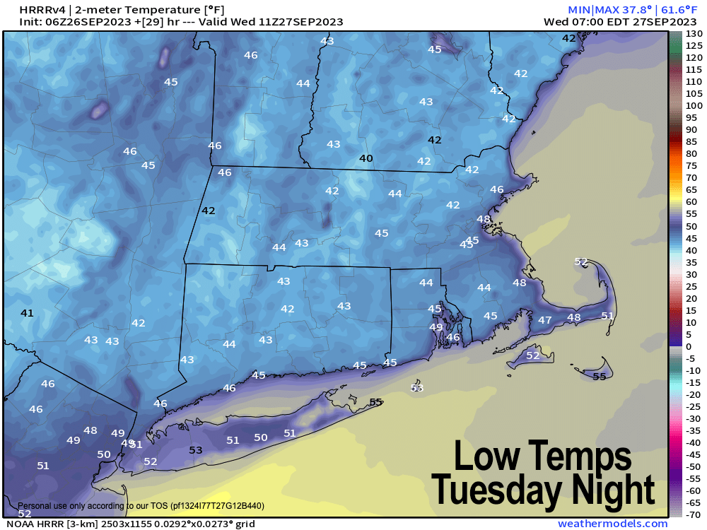
–Highs low to mid 60s, drying, lower humidity, with lows upper 30s to low 40s tonight
–Wednesday and Thursday look superb with sunshine and highs in the mid to upper 60s and lows in the 45-50º range
–On Friday, a weak wave will approach from our southwest and if it gets north enough could bring a period of scattered showers
–Behind this wave is warmer air that will build through the weekend into next week
–Accompanying this warmth will be dry conditions and increasing sunshine that should last into the middle of next week with some folks approaching 80º by early next week, but before we talk details let’s check a note from our local and delicious sponsor, #TandemBagelCo, with their newest location in the Stop & Shop Plaza on King Street in Northampton, MA.
~~~~~~~~~~~~~~~~~~~~~~
>>> A NOTE FROM OUR SPONSOR <<<
Dave Hayes The Weather Nut is Sponsored by Individual Community Members, Patrons & Tandem Bagel Company… No matter the weather, Tandem Bagel is always there for you at several valley locations to make your mornings brighter! With bagels baked fresh daily (including Gluten-Free options), house-whipped cream cheese, coffee, and tons of lunch options, Tandem is the perfect quick stop for lunch, breakfast, or a coffee and bagel to go. Find them in Easthampton, Northampton, Hadley, Florence, and West Springfield, or use their super-streamlined online ordering tool by visiting their website.
>>> MORNING DISCUSSION <<<
Good morning everybody, after 3 days of periods of rainfall which has soaked the ground for some, we are entering a non-tropical, much much drier pattern for the next 7-10 days, so for sunshine lovers, blue sky dreamers, and daydream believers, I am personally granting all of your telepathically-received wishes!
#YouAreMostWelcome
For today, lingering moisture in the form of a few northeast CT and southern CMass showers or sprinkles along with plenty of clouds will start our Tuesday.
Partly sunny skies should develop from north to south, but some areas south of the Pike may stay socked in the clouds most of the day. Highs will reach the low to mid 60s for most of us, and possibly hang in the upper 50s in elevated parts of southwest MA down into northwest CT.
Lows tonight with skies that continue to clear should settle into the upper 30s to low 40s.
High pressure continues to build in from the northwest originating in Quebec Province tomorrow, which should deliver a couple of fair weather days for Wednesday and Thursday with sunshine, highs in the 60s and lows in the 40s.
Friday afternoon into the evening is when we have to watch for another potential round of scattered showers with a weak system pushing in from the southern Ohio Valley toward the northern Mid-Atlantic coastline.
Highs again will be in the 60s, and for now, this does not look like a washout of any kind, so while I will refine it as we get closer, expect some showers to wet the ground Friday afternoon and night.
Beyond Friday, we’re looking at a huge storm pushing into the Pacific Northwest in the U.S. and Canada that will help flex new high pressure in the eastern U.S. as old high pressure tracks east off of the coast, producing a southwest flow.
This together will help provide more in the way of sunshine, but also warmer temperatures through the weekend and into at least the first half of next week.
In fact, this weekend is looking pretty stellar at this point, with highs in the low to mid 70s and lows in the 50s with plenty of sunshine.
So as vocal as some of you are about the inclement crap conditions of this past weekend, let’s hear from you this coming weekend should such fine weather come to pass!
Warm and sunny conditions should persist into the first half of next week when temperature ranges may climb into the mid 70s to even low 80s for a few folks!
Hang in there and have a great day, lots to look forward to weather-wise!
>>> BE KIND <<<
“Hello babies. Welcome to Earth. It’s hot in the summer and cold in the winter. It’s round and wet and crowded. On the outside, babies, you’ve got a hundred years here. There’s only one rule that I know of, babies: Goddamn it, you’ve got to be kind.”
–Kurt Vonnegut
