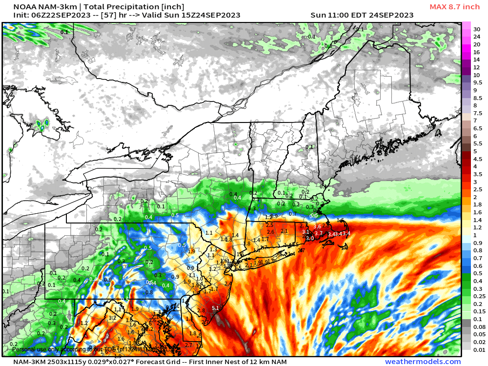
Sharp northern cutoff to rain on Saturday more likely scenario.
>>> YOUR DAILY CELESTIALS <<<
STAR:
–OUR STAR ROSE AT: 6:37am this morning
–OUR STAR WILL SET AT: 6:47pm this evening
–TOTAL DAYLIGHT TIME: 12 hours and 10 minutes
MOON:
–OUR MOON WILL SET AT: 11:03pm this evening
–MOON SET DIRECTION: Southwest
–OUR MOON WILL RISE AT: 3:36pm tomorrow afternoon
–MOON RISE DIRECTION: Southeast
–MOON PHASE: Waxing Crescent (46.1%)
~~~~~~~~~~~~~~~~~~~~~~
>>> DAVE’S WEEKLY WEATHER NUTSHELL <<<
–Patchy fog burns off with high clouds building today
–Fair weather expected with filtered sunshine, highs upper 60s to low 70s, low humidity
–Clouds build tonight, lows in the upper 40s to low 50s
–A first band of showers tries to reach up into northern CT by early Saturday afternoon
–Dry air may lead to dry conditions or just isolated showers north of the Pike, and very likely along and north of Rt. 2 corridor
–East to northeast breezes pick up Saturday night into Sunday, gusting 15-30mph by Sunday into Monday
–Sunday holds the best chance for rain in many areas of the WMass region as the storm comes closer, but even that isn’t a lock
–Any showers abate on Monday after highs this weekend in the 60s with lows in the 40s, and it might stay in the 50s in the hilltowns on Saturday!
–Partial sunshine by Monday afternoon with fair and cool/dry weather most of next week with a warming trend, but before we talk details let’s check a note from our local and delicious sponsor, #TandemBagelCo, with their newest location in the Stop & Shop Plaza on King Street in Northampton, MA.
~~~~~~~~~~~~~~~~~~~~~~
>>> A NOTE FROM OUR SPONSOR <<<
Dave Hayes The Weather Nut is Sponsored by Individual Community Members, Patrons & Tandem Bagel Company… No matter the weather, Tandem Bagel is always there for you at several valley locations to make your mornings brighter! With bagels baked fresh daily (including Gluten-Free options), house-whipped cream cheese, coffee, and tons of lunch options, Tandem is the perfect quick stop for lunch, breakfast, or a coffee and bagel to go. Find them in Easthampton, Northampton, Hadley, Florence, and West Springfield, or use their super-streamlined online ordering tool by visiting their website.
>>> MORNING DISCUSSION <<<
Good morning everybody, we’ve got a fair weather sandwich with an unfortunate wet weekend filling, so this sandwich won’t be very tasty for most, but there is a hope that a substantial amount of dry air will be entrained into our greater WMass region to knock rain totals back and keep more dry periods around north of the Pike, at least for Saturday if not all weekend long.
For today, we’ve got the last in a lovely line of fair weather days, but unlike recent clear blue sky days, we’ll see some high clouds working into the region after morning fog evaporates.
Highs today will reach to either side of 70º with partly sunny skies on average and a light east wind. Lows will drop to either side of 50º as clouds increase.
For Saturday, high pressure to our north will be draining drier air south toward our region, while a first wave far north of the subtropical low center near the Carolinas will be sending a rain shield into the southern New England coastline.
Most of us except for central and southern CT should be dry during the morning, with showers slowly lifting north into dry air in place, possibly producing some scattered showers up to the Pike or a bit north of there by mid to late afternoon.
However, between dry air to the north, and a dry slot working in from the southwest by evening, I really don’t think that areas north of the Pike are going to see that much rain, if any, from Saturday’s wave. It’s mainly south of the Pike, and even then it might not exceed a quarter inch, if that.
I will update on the weekend in the morning.
East to northeast wind will slowly pick up Saturday afternoon into Sunday, and it will be chilly Saturday with onshore flow and highs only in the upper 50s to mid 60s! Lows will be in the upper 40s to low 50s.
As the storm comes north and tracks somewhere into the Mid-Atlantic region, we may see showers push further north through the WMass region, so Sunday looks more rainy than Saturday at the moment.
Still, though, newly-forming, slow-moving tropical systems track “weird” many times, and so we may see a similar set up to what I think will transpire Saturday, but for now, assume Sunday is showery at times for everybody, with moderate to heavy showers possible, and I will update through the weekend to refine things.
It’s chilly Sunday too, with highs in the low 60s and lows in the upper 40s. Monday looks like a period of showers is possible before this storm pulls east and out to sea.
Fair weather then moves in behind the storm, as a giant high pressure system lasts through much of next week with highs in the 60s and lows in the 40s, with a chance to crest 70º by late next week.
Have a great day!
>>> BE KIND <<<
“Hello babies. Welcome to Earth. It’s hot in the summer and cold in the winter. It’s round and wet and crowded. On the outside, babies, you’ve got a hundred years here. There’s only one rule that I know of, babies: Goddamn it, you’ve got to be kind.”
–Kurt Vonnegut
