>>> YOUR DAILY CELESTIALS <<<
STAR:
–OUR STAR ROSE AT: 6:26am this morning
–OUR STAR WILL SET AT: 7:07pm this evening
–TOTAL DAYLIGHT TIME: 12 hours and 41 minutes
MOON:
–OUR MOON WILL SET AT: 6:03pm this afternoon
–MOON SET DIRECTION: West-Northwest
–OUR MOON WILL RISE AT: 3:45am tomorrow morning
–MOON RISE DIRECTION: East-Northeast
–MOON PHASE: Waning Crescent (11.6%)
~~~~~~~~~~~~~~~~~~~~~~
>>> DAVE’S WEEKLY WEATHER NUTSHELL <<<
–Rainy morning ahead for many, don the galoshes
–High temps 75-80º today through Wednesday, lows 60s
–Stagnant air mass, as we need upper trough to sweep through Wednesday to send this humidity seaward
–Periods of showers today and tonight, some thunder
–Flash flooding possible, especially east of the I-91 corridor
–Rain abates tonight, then a few isolated showers Tuesday, party sunny, a bit drier
–Humidity and rainfall returns Wednesday with a soaking rain possible as a front sweeps the region
–Drier Thursday and Friday with lower humidity and more sunshine
–Hurricane Lee is a growing concern for eastern MA impacts up into Maine and western parts of Atlantic Canada, but before we talk details let’s check a note from our local and delicious sponsor, #TandemBagelCo, with their newest location in the Stop & Shop Plaza on King Street in Northampton, MA.
~~~~~~~~~~~~~~~~~~~~~~
>>> A NOTE FROM OUR SPONSOR <<<
Dave Hayes The Weather Nut is Sponsored by Individual Community Members, Patrons & Tandem Bagel Company… No matter the weather, Tandem Bagel is always there for you at several valley locations to make your mornings brighter! With bagels baked fresh daily (including Gluten-Free options), house-whipped cream cheese, coffee, and tons of lunch options, Tandem is the perfect quick stop for lunch, breakfast, or a coffee and bagel to go. Find them in Easthampton, Northampton, Hadley, Florence, and West Springfield, or use their super-streamlined online ordering tool by visiting their website.
>>> MORNING DISCUSSION <<<
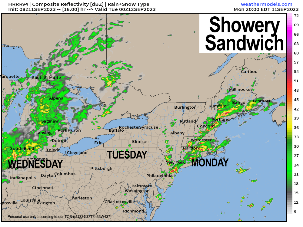
Good morning everybody, while we get a break in the action tomorrow/Tuesday with only a few isolated showers and a partly sunny day, we’re essentially in the same soupy air mass through Wednesday night, so I hope you like Monday’s soup special: periods of showers with some street flooding possible.
Mmmmmm… MMMM!!! That sounds good, Dave, got any crusty sourdough to go with that?!
After patchy fog evaporates, highs will reach 75-80º with very muggy conditions, and given warm temps high above our heads and a saturated atmosphere, showers that do fall will tend to be on the heavier side, with some downpours and a few thunderstorms as well.
This means that street flooding and flash flooding is possible today and tonight as slow-moving cells dump heavier rains at times, especially east of the I-91 corridor in eastern parts of WMass, CMass, and northeast CT.
Rain showers continue tonight and then dissipate after midnight with patchy fog and lows in the low to mid 60s.
Tuesday provides a bit of a partly sunny respite with highs in the mid to upper 70s, a little less humid, and only a few isolated showers, with patchy fog again tomorrow night as humidity creeps back up.
By Wednesday, FINALLY, our upper level trough over the Great Lakes is going to get kicked into gear with some atmospheric espresso thanks to incoming high pressure behind / to the west of it moving along to the east.
This means a potent pre-frontal trough area will slide east into New England, ahead of an incoming cold front which will sweep more showers and thunderstorms into the greater WMass region Wednesday and Wednesday night, with heavy rain expected at times.
Flooding will be possible, and some stronger thunderstorms also cannot be ruled out. Highs again will be in the 75-80º range with lows in the low-mid 60s.
By Thursday and Friday, high pressure noses in and dries us out substantially with highs in the 70s and lows in the upper 40s to mid 50s with much lower humidity and more sunshine.
Then we turn to Hurricane Lee for the weekend, generally the Saturday eveninig through Sunday timeframe.
I am not going to talk much about Lee in this report and save it for a late afternoon / evening report today where I will go into lots of detail about what the latest information is on Lee, the trends, and my thoughts about the storm.
The bottom line is that I have held off talking much about it until now because were just too far away, but trends have been occurring that tell me that a landfall as far west as Cape Cod Canal is within the realm of possibility, so it’s time to dive in.
Look for my Lee report late afternoon or evening and between now and then, don the galoshes, folks!
Have a great day!
>>> BE KIND <<<
“Hello babies. Welcome to Earth. It’s hot in the summer and cold in the winter. It’s round and wet and crowded. On the outside, babies, you’ve got a hundred years here. There’s only one rule that I know of, babies: Goddamn it, you’ve got to be kind.”
–Kurt Vonnegut
